Rain.
Wet.
Overnight at least, the morning was just drizzling with those heavy drops when the wind blew in the trees.
I ate brekkie sitting under a large rata tree trunk, growing horizontally across the track, and gained some shelter.
The tent was rolled up wet. The whole forest was wet and you have to push through the ferns on this crazy wiggly, woggly path, the water race following the contour and on a map just looks the zaniest of paths, designed by someone with attention deficit disorder. You wind in and out making little progress in a northerly direction but you must admire the enthusiasm of the diggers.
At one point the track is washed away, I had failed to notice a diversion but proceeded anyway, and found I was scrambling up a 4 m near vertical slope. In the end, I took my pack off, still more than 10 days of food aboard, not so easy when clinging halfway up the slope, and wedged it against a tree, clambered over the whole caboodle, thinking my pack, then myself would drop and I’d be starting the whole process again.
Eventually popped out onto Cascade Road, “road” certainly flatters, 4WD track might be a more accurate description, and you find you have only climbed about 100 m in the last 25 km of windiness.
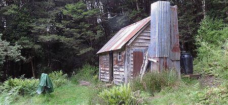
So you make up for it with a more direct climb up to the historic hut, built in 1905, the first encountered. Martins Hut has a floor, mostly, four bunks, and a huge open fireplace.
The makers of the beach footprints I have been following on the sand for two days are in residence, they are having a rest day in the historic ambiance of the hut. Fiona and Anthony are cheery company. They started their Day 1 from Bluff the same day as me, but were early risers and had just walked around Bluff Hill, ie, back to Bluff. Guess they had finished their day’s walking by the time I had plodded around from the ferry. They continued to Invercargill on my day off, then overtook me while I was drinking coffee and getting extra provisions at the supermarket on Day 3.
Fiona fills me in on some of the imminent TA issues: the crossings of farmland and private forest required in the next couple of days. It’s complicated, but then again it’s New Zealand, not the USA, I’m unlikely to be met by gun-wielding rednecks. She is also as well prepared for a three-month walk as it is possible to be. Their itinerary has been worked out, much food has been stashed for pickup along the way, a year spent dehydrating dinners, clearly Organisation+.
Here’s a little secret. While I was well sorted for my recent Stewart Island Little Adventure, I’m frighteningly under-prepared for the full TA experience. I might have printed off the first section of the official maps, Bluff to Queenstown, but otherwise, I have little inkling of the route. I haven’t even read the trail notes from the official Te Araroa website.
I don’t know how far I can walk each day, and I don’t know how many days it’s going to take to get even to Queenstown. No, I haven’t studied the maps too closely but I have at least worked out it is about 320 km from Bluff to the Greenstone Road end, ie, where the track stops before Queenstown.
So, how long does it take to walk 320 km?
Guess I’m gonna find out. As usual, the hard way, through experience.
A guide to the night’s accommodation: Martins Hut
