Where?
That doesn’t seem right.
The 5 30 am weather report on the radio gave me something to think about. Heavy rain in parts of the North Island, extending down as far as Nelson. The forecast for Buller/Westland was for low cloud later in the day.
I have been contemplating crossing a mountain range to get to a few valleys with no bridges over the big rivers. An energy expending day to get to the next hut, a 1000 m climb and descent, and then some huge days to access shelter from there. Walking in any direction could be a major problem after heavy rain, as big rivers would need to be crossed to get to each of the huts. The top Trent River with its “50 river crossings”, as stated on the Permolat website, might just prove too much for a guy out here on his own.
If the summer weather had been more stable I would have had more confidence in avoiding being stranded in my tent for a few days with the rain coming down once again. After sitting in Lake Christabel Hut for three nights, and that bleak morning at Brass Monkey, or the whiteout conditions that persuaded me to go down to Lucretia.
And I’d been fully rained out of the West Coast, before the New Year, and later in January the Waiau and Henry Rivers had majorly flooded. You get the picture.
Common sense suggested an alternative was needed.
I could go down out down the river, and go home, but I wasn’t ready for that.
What I really wanted was some more striding, like my general experience in Marlborough. An easier track. I had some pent up energy, but of the walking, rather than smashing kind.
Despite the reasonable looking day I canned the idea of the 1000 m climb and descent to Slaty Creek Hut, and what was going to come afterwards, ie, the remainder of my planned trip, and headed down the river to the gravel road.
Big decision, but sometimes reality, and the fact I am travelling by myself needs to prevail.
There is a well marked DOC track down the river so my morning sounds easy enough. But there were some significant obstacles.
First up a big slip that made continuing on the same side of the river entirely awkward. I decided to cross the Robinson River and crossed back a few hundred metres downstream. That worked. Just over thigh deep.
Then there were hundreds of fallen trees. The track had been washed away with no alternative route other than finding your own way. That became seriously hard work.
This was how I had my second thought-provoking moment of the summer.
The first had been seeing my pack floating down the flooded Whitcombe River, back before Christmas.
Today was different. After one 400 m cross-country ramble through some windfall I popped out on the track and looked down to see my pouch containing my GPS and emergency locator beacon was empty.
Man!! The zip had opened up at some point since I left the hut, and they had both dropped out!!
This has happened before, when I was up Mount Fell in the Richmond Range behind Nelson, fortunately on snowgrass where they were easily visible. That experience had encouraged me to tie a short length of pink plastic ribbon to each. Also on the plus side I generally notice if my pouch doesn’t feel right. Maybe they had fallen out not so long ago.
On the negative, well, I’d smash my way through a confusing jumble of mature fallen trees, pushing through dense bracken, etc. This was not easy travel.
At least I didn’t have to take my pack when I went to look.
Amazingly I could kinda work out my route when I rewound my memory banks, and after 150 m I found my locator beacon, usually at the bottom of my pouch. Maybe it wasn’t so far away.
The GPS wasn’t so easy to find, and I made it back to where I had climbed a crazy five metre gravel bank at the point the track had fallen into the river. No point in going further upstream.
At least I had been able to make out my passage through the jungle, pretty much, except now I was totally confused. Discombobulated.
Lucky. On the way back I saw some pink ribbon in the sunlight. The black GPS was hiding under a fern.
Back on track, although after a small celebration at finding almost $1200 of equipment, the track continued to be elusive.
The reality of modern river travel came into stark relief. It didn’t take much in the way a windfall, or crossing mid-thigh height rivers to realise it can be extremely slow.
Then I was out on the open expanse of Lynchs Flat, and it was all over.
Yay! The swingbridge.
Or was it?
I ended up crossing back over the river to get around another section of washed out track with rows of windfall trees to clamber across. The river seemed the easier option. Then, of course back again. That made four crossings for the morning.
I wondered what it would have been like with multiple crossings of those much bigger rivers on my earlier itinerary. I was now glad to have decided on an easier life for myself.
In the forest at the start of a four wheel drive track was a new sign saying Robinson Track. Must now be over.
Except there was a deer fence and a horrible up-and-down trajectory for a few kilometres on the wrong side of the fence, through long grass, numerous small soggy streams, not the farm road I’d been imagining.
When you are complaining about that sort of thing you know that you are well over it.
Eventually after the four river crossings, scrabbling trying to find my technology in a jungle, and 15 km of basically “flat” river travel, I was out on the road.
When I say “road” it services a solitary farm at the end, might not be a lot of traffic and it’s about 25 km to the Reefton Highway, State Highway SH 7.
Man, at least I could make progress.
After an hour and a half a four wheel drive came past, but the wrong way. After I had smashed out another kilometre or two they returned, picked me up, took me to the highway. Then turned off to Reefton. They were doing what a few people do, if there is a road, go to the road end for no apparent good reason on a Friday afternoon.
Yay! I wasn’t walking for once. Those cars can be a very comfortable method of travel.
First people I’d seen for a week, and fortunately they already had the windows down. No problem about my pong!!
3 20 pm.
At the highway junction it was 4 km to Springs Junction, cars zipped past and I ended up having to hoof it. I wondered what people were thinking seeing a stray tramper out on the road, gaiters covered in dust, oh, now mud, shorts ripped and filthy. Etc.
By now it was quite gloomy as I sat at a Springs Junction picnic table in the large petrol station carpark eating a burger. Friday afternoon, apparently. The cars came past in big streams.
Then, while I was creating a sign saying ST JAMES, a guy stopped and took me back to the Lewis Pass car park.
I had decided that with so many days’ food still, I might as well walk back to St Arnaud.
On well beaten tracks.
With other people around.
I really wanted to stretch my legs for the last bit of my tramping summer.
At the start of the St James Walkway I took a photo to find out the time. 7 pm.
Yikes! It was a three-hour walk to Cannibal Gorge Hut, on this longest day of tramping since forever. I would be spending the last hour or two in the dark.
Down at the Cannibal Gorge swingbridge I noted I had misunderstood the time. It was reading 17 20, that’s only 5 pm. Still, better make haste with fine drizzle coming down.
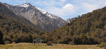
I staggered into the Cannibal Gorge Hut after 8 pm, a welcoming open door visible from some distance, but, as usual, I had only myself for company. No worries at all.
A big day, more than 12 hours, and I had walked a big 33 km, including all the scrabbling around in the jungle.
Should sleep well, as the rain came down.
A guide to the night’s accommodation: Cannibal Gorge Hut