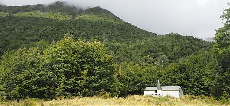
One look out the window in the morning and I could tell I was back in the clouds again.
Oh, maybe the window has steamed up.
On with my glasses.
Nope. Can’t see those nearby mountains, and even the tarn is misty, and that’s only 20 m away. Warm though.
Visibility is very poor, I can’t make out the landscape on the other side of the tarn.
The options are clear.
Forge on, it’s a 2 km sidle to the ridge, and then see if I can make my way down to the Rough Creek — Christabel track without getting bluffed. It’s a six-hour walk to the Lake Christabel Hut, 40% of which is going down the creek on a DOC marked track in the forest.
The difficult bit is the exposure to the weather until I started dropping on the other side of the ridge, and avoiding bluffs as I go down.
Or, if I hang around another night I might be trapped in the hut while the predicted deluge does its thing. I might state that the bivvy is tiny, about 2 m x 2 m. There won’t be a lot to do.
Well, fog makes a change in this most dubious of summers. When is the summer season going to start?
Decision time will be 11 am. Maybe it will clear a bit.
But after that foggy day before yesterday I seriously doubted it. Still, I had managed to navigate my way fairly successfully with my GPS, even if I could see very little.
At 10 30 am I had packed up, and despite a lack of change in the weather I gave it a go.
After just 200 m I realised that the fog/wind combo was excessive, I was almost blown over despite my heavy pack, and headed back to my little damp shed. Unpacked everything and got back in my sleeping bag. Soon I was having a snooze.
Later, I thought I’d cook up a dinner for lunch, have a decent feed in the middle of the day for a change. Just as I threw the rice in the pot it seemed a little brighter, and by the time the rice was boiling I was packing everything up again.
The cloud lifted, although it was still blowing.
Now all that was holding me up was eating that boiling vat of food.
It was after 2 pm when I finally made a dash for it. There is a 2 km sidle that starts on snow grass on a gentle slope, and gets into more steep, gnarly territory where you are unsure of whether to go up or down to get around the bluffy bits, scrambling through the red tussock and bog pine.
There were a few chamois tracks to follow, an animal known for its dexterity in mountainous regions.
Eventually I found myself struggling up the last steep bit onto the ridge. I elected to follow the huge arc of the ridge to meet up with the track over from Rough Creek and as usual with ridges it did a lot of up-and-down, little peaks and saddles. At least the top of the ridge was reasonably rounded and had a great covering of snow grass. That meant speedy walking.
4 pm up on the ridge. 5 pm around the snow poles. 6 pm finally into the forest.
I had contemplated taking a shortcut directly over the edge, but later thought my more conservative route paid off. The river turned out to be a deep ravine, and the track was a fair way up above it.
At times the walking was sublime, as nice a track as you could wish for. There was a short stretch where there was almost continuous sheet waterfalls into the deep ravine, maybe a 20 m fall.
Not much time to contemplate the general landscape, I was using all that fitness I’ve gained over the summer to motor along, wary that one minute of looking around might be worth five minutes of scrambling when the light deteriorated.
Then it commenced to rain fairly significantly. I had my raincoat on over my softshell jacket. That clothing combination had me heat up once out of the wind, and after dropping in altitude a fair amount, but I didn’t want to stop.
I was a man with a mission.
Eventually, 7 45 pm, I hit the swingbridge and knew the hut was very close by. Just as well, I was totally soaked by this stage.
In the end it took almost 6 very vigorous hours. Despite the late start I feel I put in a fair effort.
Fading light as I made it to the hut, dense clouds above, heavy rain predicted for tomorrow.
Looks like I will be having an enforced rest day tomorrow.
A guide to the night’s accommodation: Lake Christabel Hut
