It was almost as if I’d been in training my whole life for this day.
You could describe it as awesome, in the archaic sense, filling you with awe, not in the current, diluted meaning — yeah, pretty good.
Massive day, it was hard to take it all in, but, man, I sure appreciated having been so lucky to have totally splendid weather, ie, reasonable visibility. Those big views kept coming after the initial bush bash/climb up the broad granite lump. The first view was of Lees Knob, a significant granite dome. Lee must have been quite a character, but that was just one of many similar domes that unfolded. The rest all yet to be named. I could see from Lees Knob around to Lords River/Tūtaekawetoweto and Big Glory Bay, even way over to the Catlins, halfway to Dunedin, if I chose to look back.
It was starting to look very remote down there, all scratchy mānuka and olearia under the bushline, with some equally robust bog pine for variety, with extensive granite areas in between the general covering of shrubbery. No tracks, just a few hunters’ huts in close proximity to the coastline.
You don’t travel over the main peaks of the Tin Range if you keep to the route. Instead the vague trail sidles around the eastern face of Mt Allen, useful shelter with the strong northerlies slamming in. But the gales lost their grunt during the day, much as I did.
I came across the lake under Mt Allen, very shallow, complete with large golden beach at the northern end. I had read accounts of others camping there, what’s not to like about pitching a tent near the picturesque lake in the late afternoon shadow of Mt Allen that rises steeply above. The reality was there was no easy camping spot even for a small tent. The golden sand was entirely damp, the closely wind shaven vegetation at the north end was on a significant slope, the southern zone only slightly better. People had obviously camped in the past, but it would be awkward. Overall Twin Pools Crossing was the spot to stay, at least for me.
Then I climbed around to the main ridge but where was that track? I was following the vaguest of trails with the occasional silvery twig poked in the ground, not a lot to go on.
Here’s a handy hint for anyone else venturing this far south: if you travel somewhere near the top of the flat ridge, it would often be good enough to keep on track. If I was able to correctly guess where to crash through the intermittent waist or head high patches of scrub that separated the longer stretches of shaved vegetation, there wasn’t much of an issue with route maintaining.
Once I made it around onto the main Tin Range ridge the view to the west opened out. Doughboy Bay could be spotted again, quite close, probably around 7 or 8 km away in direct line. In the distance, on the horizon to the north, I could make out large areas of snow on the peaks in Fiordland. And some not inconsequential island way out to sea.
It was now a balmy summer’s day, 20° C, perhaps more, little breeze, clouds mostly higher, so a perfect walking day.
There was a super fun part where I lost the track, or maybe not, around Granite Knob, that was another full-on wrestle through the scrubbery. I needed to move my tent inside my pack or the tent bag would have been shredded. My hands received more painful divots, that’s a small price to pay for the extraordinary experience. Leather gloves would have proved useful.
With the main ridge running away to the south the view in that direction was obscured by a series of high points, Granite Knob initially and then a few undulations to the last big hill.
I’d mucked around for a long while during the day, taking my time due to the surprisingly good weather and having various short side trips exploring, so it was mid-afternoon by the time I finally made it to the top of the prominent bump in the ridgeline demarcated as Hill 637 on the map.
Wow!!
That was fully amazing, one of the best vistas of my life.
All of a sudden there was Port Pegasus/Pikihatiti and the offshore islands, Pearl Island prominent, much closer than I imagined, and, what I’ve been waiting for, Gog, that crazy inverted ice cream cone style dome of bare granite, 400 m in elevation, way in the distance. I could see almost to South Cape/Whiore, the southernmost point of Stewart Island but there were some not inconsequential hills in the way. Over to west was the Titi Islands where Māori adventurers had come for muttonbirds in their canoes, and still did, I guess, using the motorised version.
I was sure I could make out Antarctica way in the distance directly to the south, but it might have just been various icebergs.
Yahoo!!
I let out a scream spontaneously, thinking I’d sound like Tarzan, I guess, but with a dry throat my voice cut out unexpectedly. Fortunately there was probably no one within 20 km of me, down at Doughboy perhaps. I didn’t try again, but I did feel exuberant.
I had traded possessions for experiences, security for freedom.
This was the payoff.
There it was. Hugeness, remoteness, wilderness all rolled into one.
Up there I could sense my own remarkable insignificance, one small individual humbled by the unfathomable sparseness in front of me.
A feeling of my transience, amongst the eternal of the landscape.
It had been a long haul, not only the last four days’ efforts, I required my entire life for this point, the skills and determination required to make it to Hill 637, but more crucially the stillness in my mind that made me capable of taking it all in and realising the importance of the moment.
There’s something about that instance, an important moment that I immediately knew would remain with me for the rest of my life.
Like boyhood memories of the Inangahua earthquake where my bed shook its way across the room, the kitchen items deposited themselves on the floor, and a couple of internal windows not only cracked but shattered down the stairs, and I knew there were uncontrollable forces in the world that could make themselves apparent at any time.
Like a sunrise I once experienced as an 11-year-old on the south coast of New South Wales, a short walk from the family’s borrowed holiday house, in the week between Christmas and New Year, pre-Daylight Saving so technically early, a rosy glow and then the sunlight coming through the waves which for a moment were transparent and filled with small fish, me thinking about the rest of the world back in their beds, missing out, the day already warm, and promising and exciting, not least by knowledge of the deadly funnel web spider in its, err, funnel web immediately above the front door, and all the time thinking I might have to deal with the world all on my lonesome.
Or my first fumbling sexual encounter near the Cathedral Steps in Nelson after staying up all night and thrilling to the intensity of feeling, closeness with a warm body and a lively mind, wanting, needing to make a meaningful connection with another empathetic soul.
Or making it to the top of Mount Sonder/Rwetyepme for the first time, and having the nutty central Australian landscape spread out way below. Over there, Gosse Bluff, where a 1000 m wide CO2 gas comet smashed 5 km deep into the Earth’s crust around 145.5 million years ago and left an enormous spinifex covered amphitheatre, a range that looked as if it had been constructed by a child with the comb, and the world’s oldest watercourse, the Finke River as it failed to do its occasional flow thing down the obvious route of the valleys but instead followed a line drawn like some doodling planner who directed it perpendicularly through a number of mountain ranges until it puttered out somewhere in the Simpson Desert, and all the other misshapen and random geological formations, coloured mainly by hues at either end of the spectrum, violet or almost infra-red and seared its way into the Unforgettable section of my memory banks.
Yeah, Hill 637 was really up there.
At this moment I had everything I needed, my pack lay on the ground with my physical essentials, my mind’s relentless wandering for once still and at peace.
We surround ourselves with people, possessions, activities to avoid this confrontation with ourselves in our routine lives. Here I was: stripped, alone, and strong. This was one of the most significant moments in my lifetime. The present was right in front of my eyes, no need to dwell on the past, or contemplate the future. Everything important was just in front of my eyes, all new, not able to be grasped in its entirety, that was enough, if not too much. All senses operational without the need for thought or processing.
I felt a surge of life. Pure exhilaration.
My luck with the outstanding views coinciding with great weather continued and no surprise I sat around up there for a couple of hours, flicking my attention from the big view to the shape of the leaves and what was more immediately surrounding, smelling the damp vegetation’s summer smell, both growth and decay in the same instant. Sheltered and basking in the warm but weak summer sunlight. Totally at peace, there was no stopping my grin.
No point in hurrying elsewhere. It really was the place I wanted to be.
But eventually, sun lower in the sky over to the west, I continued along the ridge, heading down, then after a kilometre or two the trail dropped more steeply, more scrub to push through, the track once again not at all obvious, but I could work out the general direction, there was a large open area near a creek at the bottom.
Just crash on down.
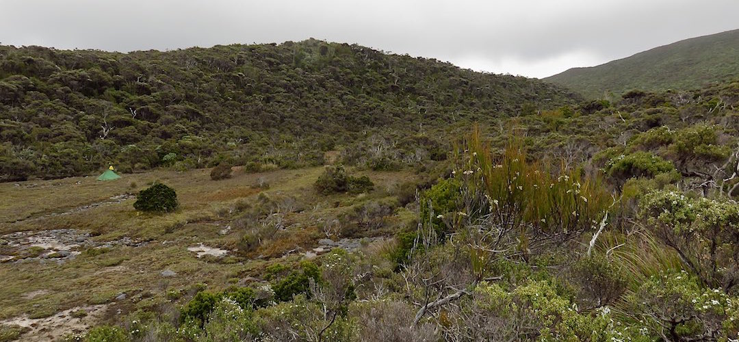
I whacked the tent up at the most substantial camping area in the range, just in the large flat open area adjacent to the inky creek, protected to some degree from wind. I had always planned to stay around there for two nights, rain had been predicted for the next day as a front swept through and, coincidentally, I could rest my body from lugging that pack, still all too heavy.
No hurry, no hurry at all.
A guide to the night’s accommodation: Tramline campsite