Blue sky to start. Then some wispy clouds, but most of the day was about wind.
After three nights decent sleep, and little exercise in between, I was feeling pretty good, if not frisky, and ready to tackle some more hill climbing.
Didn’t get away super early like I planned. But it didn’t matter. The dry riverbed had a small flow that I could step across and was clearer than yesterday. At the turn off I got into the climbing business straightaway and it was interesting to move through red beech forest once again. After three quarters of an hour there was a decent bivvy, in that the rock overhang had a substantial dry patch underneath, that is of course the idea. The ground was sloping somewhat so it might not be the best place to sleep. Particularly when thinking of earthquakes.
More climbing to Wild Sheep Saddle. If sheep get up there through the forest I’d say they’d be pretty wild.
By that stage, at 950 m, it was more manuka forest. There was a DOC marked track along a steep and usually narrow ridge, sometimes rocky, to get to the main ridge that was considerably broader.
Towards the top I had phone reception so I stopped for a while for some Christmas/New Year communications.
After three quarters of an hour I thought I had better move on, but discovered I couldn’t find my glasses. I put them down at some stage, and then I had wandered round looking for better reception. It’s an alpine herb field up there, kind of bumpy, and unfortunately I really needed my glasses on to look for them.
Yeah. I found myself on top of the hill, around 1400 m on a major expedition without good eyesight. I set up a grid search pattern and then spent almost an hour combing the landscape.
Some relief when they presented themselves in a fairly obvious position. It had been a fairly sobering experience.
Note to self: pop your glasses in a pocket when on isolated mountaintops.
With them on I could look over the other side of the ridge and see that Tappy, ie, the 2,885 m (9,465 ft) Tapuae-o-Uenuku, the translation from the Maori of which is the poetic “Footprint of the rainbow”. Oh, it had a surprisingly large dump of snow, considering it is almost the middle of summer.
More trudging along the broad ridge to Point 1517 where the ridge I needed to drop down started. I could see it would be easier walking further down, but let’s just say it was steep at the top, and I was not quite certain which ridge to move down. After 100 m or so it was clear that I was on the wrong ridge and needed to cross a steep gully. At one stage, I looked down through some mountain beech trees and noted a four or six pointer stag staring at me through the shrubbery directly below.
Much of the drop was in grasslands with some sharply spiked, but well disguised Aciphylla, ie, speargrass, distributed around to keep me alert.
I spotted another four deer on my way down and spent an hour or more just watching them graze and taking photos of them. One I got quite close to due to winds and the sun behind me. The deer have created some decent trails and so even though I wasn’t on a DOC marked trail the best route was easy to follow.
There were good views of my next few days route that I peered at, working out whether it was possible to get over into the Clarence. After today most routes seem doable.
Another deer was at the hut, between the hut and the toilet.
And man, I was sick of the descent phase by then. At least I worked out how to use the deer trail system. They really know how to climb and go down steep hillsides.
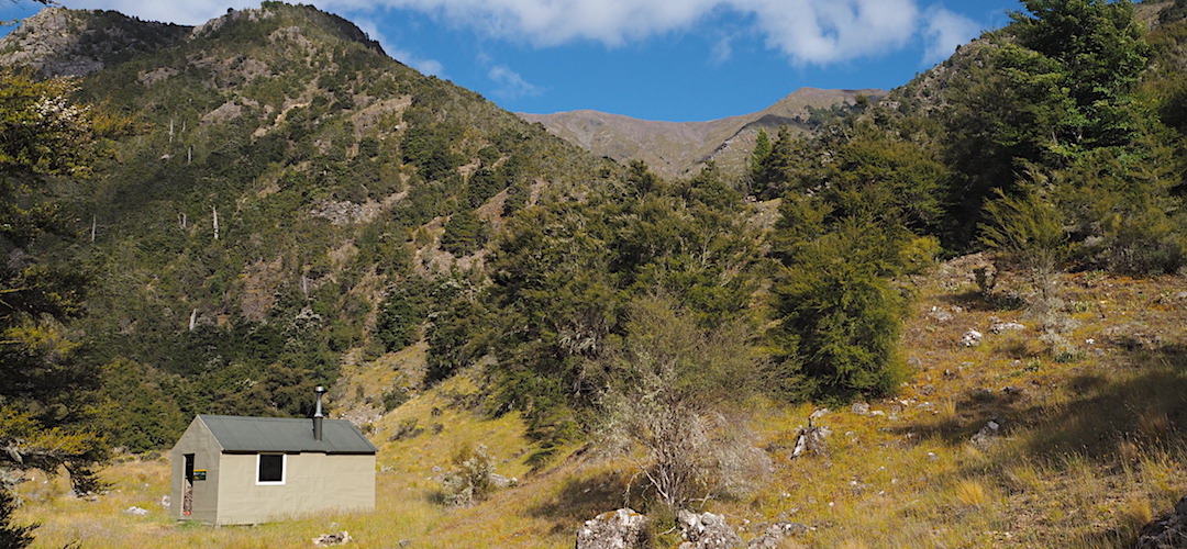
It was great to stumble across a little used standard NZFS SF 70 hut, built in 1962 and renovated more recently with new double-glazed windows and a pot belly stove. And a shelf with an array of not quite empty gas bottles. This is why I don’t generally use them for long trips. What you do with them when they are less than quarter full?
I have a Whisperlite that uses liquid fuel, Fuelite, where I just refill my bottle. But on a lengthy excursion like this one I found it useful to carry a screw-on gas burner for those gas canisters others leave behind. I can cook my dinner properly rather than boil for two minutes, put the lid on, and leave for another 10 minutes to keep cooking without using any more fuel.
Well, my body fuel was all used up with that 1000 m of climbing again, and then having to lose all the elevation in a rush later in the afternoon.
It’s been a good day.
I’ve had an hour of communication, first talking with another human for a week. I found my glasses. I picked the best route down the hill, and the others looked like having significantly gnarly moments. Now I have the hut to myself, once I’d startled the deer away, and making exceptions for the swallows nesting in the porch.
A guide to the night’s accommodation: Penk Hut