If you need a tramping itinerary, I’d suggest you avoid Pell Stream. Particularly via Point 1201.
Despite saying that, I enjoyed the day. Patches of blue sky. Occasional direct sun.
With all the pest control traps around, there was plenty of bird life. I saw a kākā at close range and had a flyby. Kākāriki chattering just behind the hut, and on the top of the slope.
Yes. That slope.
I found that stopping to observe the kākā was a great excuse to, umm, pause my uphill progress for a while.
It started well. I wasn’t aiming directly towards Point 1201. I could see bluffs near the top from the hut first thing in the morning, so aimed along the ridge at about 1000 m.
The morning had its moments of scrambling through the regenerating bush on steep slopes.
Just keep going was my method.
There were large areas of old windfall on the main ridge, and surprisingly little in the way of deer or possumer’s old tracks.
Might point out here that my GPS died on my last trip, the chip with its maps finally conked out, as well as the silicon or whatever cover getting greasy and starting to disintegrate. That’s on top of the sad chewing from rampant mice at Carrington Hut that ate some of the tasty silicon buttons, and chewed into the aerial casing.
I had downloaded the maps of the area to my phone but when I whipped it out for some navigation assistance, well, they hadn’t been actually downloaded as my phone was full.
I did have a proper, ie, paper map of the area, but I learned first-hand how useful it was to have a GPS point out exactly where I was located. The compass in the phone proved unreliable even though I calibrated it before using each time. My technology was letting me down. But it let me know exactly how useful a dedicated GPS unit was to your average long distance/off track tramper. Better sort that out before my series of big summer trips.
Once up to the top of Point 1201 it was not easy to work out which direction to head along the long flattish ridge. Visibility was poor with all the low trees. All ridges lead to the top of a hill, eventually. I learned not all ridges lead down to your chosen destination. Orchestrating my descent proved a matter of luck rather than skill.
Hmmm. I had some moments scrabbling around.
One thing was I did not want to drop into the Alfred River where there was neither track nor hut.
Eventually, not seeing any ridge ahead, just before Point 995 I hit a spur that may or may not have been the one that dropped to the hut. It wasn’t, but it was fun dropping 400 m or so in a real hurry in the dry mossy conditions. Certainly more fun than going up, but I’m not complaining about the day.
At the bottom there was a gravel cliff in the forest that took some sidling, and perilous moments to get down. Surprisingly there was a timber cross at the bottom in the forest that turned out to be a sign, or marker from a long time ago, although any message had long gone. Perhaps it marked the route up, but I’d say few use it.
At the hut I found I was the only person to have taken that particular route, and the hut book went back to 2009.
As a side note, the hut book contained only eight pages of entries, and there was a great deal of space around each. I counted them, almost, less than 80 parties in eight years. I was the 10th for 2017. A few tramping luminaries were noted: Sven Brabyn, Geoff Spearpoint, Danilo Hegg, Gavin Harriss, Nina Dickerhoff, and a few familiar names seen in plenty of other hut books in the region, Dave Pratt and Dion Pont, those guys sure get around. Also an old school teacher, George Carr. Now there was a blast from the past.
At least at the bottom of my drop I recognised that I was at the top of the gorge, the start of the open flat, and a track marker presented itself on the other side of the stream. I decided that as I was going to get my feet wet I might as well just plunge upstream following the river, an easier path in general and chose river crossings to get around windfall and a few bluffs.
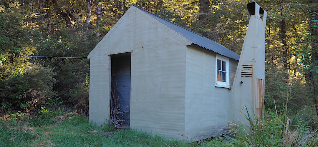
Still plenty of light when I made it to the hut, but bizarrely I chose a bunk that was shorter than average. Oh, they all are. Despite being a six-bunk almost standard SF 70 New Zealand Forest Service Hut, built in 1961, it only had four bunks. All were non-standard length. They measured 6 feet long, and I’m 6’ 2”.
It might be possible to walk past the hut if you were distracted. It’s on the bush edge but with some undergrowth around. Best to aim for the toilet, and follow the track up.
The hut would be cold for much of the year as it doesn’t get direct sunlight, and the mattresses get mouldy due to the dampness in winter. Some bleach has been left to deal with that situation.
The last people in the hut were exactly a month previously. Guess I’d be on my lonesome for a second night.
There was the sound of Pell Stream doing its thing in the background, and bird noises.
If you want to get away from civilisation for a period of time I’d suggest Pell Stream Hut will do quite adequately.
A guide to the night’s accommodation: Pell Stream Hut.