Adventure plus.
A long cableway; river travel over mossy boulders each as big as a car, a bus, a house; steep, as in very steep climbs and descents; spectacular views; big mountain river crossings; the Unclimbable Rock; high and long swing bridges; unpredictable weather, so when it rains, it really rains; and a good selection of huts.
Yup. This trip has it all. There should be no problem getting to sleep at night.
But not for the inexperienced or unprepared.
For significant portions of this route there is little of the type of track found on more popular routes such as the Travers/Sabine.
There are hours of scrabbling/scrambling/leaping over slippery boulders, or on rough trails high above the river. When it’s time to climb or descend it’s usually direct A to B travel, you go straight up or down, often pulling yourself up by your arms.
You were warned. There is a high level of energy expenditure required.
If the weather is clear there are some impressive views in this smashed up landscape with all its verticality and grandeur.
The rewards are there, but this dramatic route will test even fit and experienced trampers.
where | Toaroha/Frew Saddles Track, West Coast
From the carpark at the end of Middlebranch Road, off Upper Kokatahi Rd, in an almost loop to the Whitcombe Track carpark, near the Hokitika Gorge.
Either direction is equally possible, it really depends on how you organise your transportation.
It can also be extended to take in Zit, Lathrop or Newton Saddles.
click to view larger, more interactive topographic map from, err, topomap.co.nz
distance | Toaroha/Frew Saddles Track, West Coast
48 km
time | Toaroha/Frew Saddles Track, West Coast
4—5 days, for the fit and enthusiastic
when | Toaroha/Frew Saddles Track, West Coast
Anytime the weather is good but probably best when there are longer days, ie, the summer months, November to April.
In winter this track can be snow covered and/or icy, and require the use of crampons and ice axe.
maps and GPS | Toaroha/Frew Saddles Track, West Coast
It’s essential to have a paper map in case GPS batteries die.
Land Information New Zealand, LINZ, Topo50 maps, both digital and paper: BV Kokatahi and BV19 Lake Kaniere.
Download free digital versions from LINZ Mapchooser, or buy the real thing, ie, on old fashioned paper, at DOC offices, outdoor shops and bookshops where maps sold. There’s a nationwide list at LINZ Map Retailers.
Need a custom map for your GPS device, download a more compact .klm format file from topomap.co.nz for free, although if you download a few maps consider a small donation, there’s considerable work gone into getting that info onto the internet and we should support these useful resources.
route description | Toaroha/Frew Saddles Track, West Coast
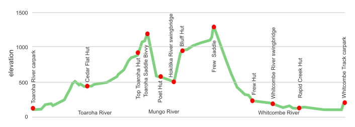
From the carpark at the end of Middlebranch Road, off Upper Kokatahi Rd, the track follows up the Toaroha River to the Toaroha Saddle. There are a number of awkward slips to climb around on this section.
The track drops steeply into the Mungo River, crossing after the junction with the Hokitika River on a high suspension bridge, and climbs, err, very steeply to Bluff Hut. The gradient generally flattens until the short but steep climb to Frew Saddle. The track then drops to the Whitcombe River at Frew Hut. All that remains is to follow out the boulder strewn river, and crossing the Hokitika River on an exciting cableway just before the Whitcombe Track carpark, near the Hokitika Gorge.
Sounds okay when you summarise it like that. Maybe should add the word battle a couple of times there.
huts and campsites | Toaroha/Frew Saddles Track, West Coast
There are no shortage of huts or bivvies along the way.
tramping times | Toaroha/Frew Saddles Track, West Coast
Here’s the DOC stated tramping times between huts, as shown on their website, usually actual walking times, ie, not taking into account any long breaks. DOC bases its estimation on these times for an experienced tramper, which means that it’s not possible to walk much faster, unless you are only carrying a very lightweight load.
Unfortunately this time information tends to emphasise a pointless aspect of tramping, The Destination, and, some trampers feel they need to test themselves, rush, to prove something to someone. Aren’t you there to experience your environment, notice things, experience the views, watch the bellbirds flitting around? There’s no actual requirement to minimise the time racing through this memorable landscape.
roadend carpark to Cedar Flat Hut
Time: 3 – 4 hours
Cedar Flat Hut to Top Toaroha Hut
Time: 5 – 6 hours
Top Toaroha Hut to Toaroha Saddle Bivvy
Time: 2 – 3 hours
Toaroha Saddle Bivvy to Poet Hut
Time: 1.5 – 3 hours
Poet Hut to Bluff Hut
Time: 3 – 4 hours
Bluff Hut to Frew Saddle Bivvy
Time: 2 – 3 hours
Frew Saddle Bivvy to Frew Hut
Time: 4 – 5 hours
Frew Hut to Rapid Creek Hut
Time: 3 – 4 hours
Rapid Creek Hut to roadend carpark
Time: 2 – 3 hours
getting there | Toaroha/Frew Saddles Track, West Coast
An awkward track to access without a car shuffle, or having a very kind friend/partner to drop you off and pick you up.
It is possible to hitch, or cadge a ride up the Upper Kokatahi Road, that’s the Lake Kaniere back road, with an hour of walking up a reasonable gravel Middlebranch Road to the car park.
Hitching to or from Hokitika Gorge is entirely possible. This is a major tourist attraction in the area, so there are at least cars going up. Asking people in the car park would probably work.
supplies | Toaroha/Frew Saddles Track, West Coast
Greymouth, population almost 10,000, has the usual major supermarkets, Countdown, and New World, both open 7 days, 7 am to 9 pm, for getting the main supplies.
Hokitika, population 3,000, has a New World supermarket, open 7 days, 8 am to 8 pm..
Gas canisters, Shellite or Fuelite for your stove can be obtained at outdoor and hardware stores if you haven’t been allowed to fly with it.
warnings | Toaroha/Frew Saddles Track, West Coast
Man, where do you start? Warnings make a long list on this track.
The Toaroha/Frew Saddles Track is only for fit and experienced trampers who are looking for arduous days over harsh country. This is one of the more demanding trips on this website.
How about beginning with the weather? The region in behind Hokitika has the highest recorded annual rainfall in New Zealand, 16.5 m in 1998, or almost 50 mm average a day. Once it received more than a metre of rain in 48 hours.
It can be wet. And when it rains it can really rain, deluge-style. When it doesn’t rain it can drizzle, a particularly wetting West Coast variety, and if it’s not raining or drizzling it can still be damp. With the river and creek crossings, and traipsing through tall, wet tussock, expect to be wet.
More importantly, all that rain quickly gets channelled into streams and rivers. Due to the steepness of the terrain the water levels can get up very quickly, and have 10 times, 50 times more flow in a few hours. Small streams can be uncrossable. The big rivers, which are big rivers even in times of drought, become raging torrents of immense power.
Be prepared to hunker down in a hut for a day, the heaviest rain usually doesn’t last long, and the rivers can return to crossable condition overnight.
Boulder hopping skills are required, big time.
There are hours of clambering, scrabbling, clawing over mossy rock. Sometimes it might be useful to have a 5 m length of rope to lower or drag a heavy pack up a steep slope.
Some instances are an hour above Rapid Creek Hut where there is an impasse if river levels are high. Also in the Toaroha River, between Crystal Creek and the main river crossing. Recent slips have, err, slipped away the track, and at one point there is a detour up/down a steep bluff while using the trees as hand/foot holds.
The “Unclimbable Rock” is a 6 m rock-face that is not possible to avoid, easier to get up or down without the impediment of a heavy pack. One slope has a knotted rope to assist, the other, well, those with a long reach and strong mind will probably survive. You just need to remember that others have traversed it, and use that nervous energy.
Did I mention the steepness?
The most gnarly climb/descent is the route from the Upper Hokitika River swingbridge to Bluff Hut. At one point in the 1970s the New Zealand Forest Service deer cullers installed two ladders, and some wire to assist, but that has long been removed. It’s slippery and ridiculously steep, but there are usually roots or saplings to drag yourself up/down. It’s a full body workout. Most really awkward bits are less than 15 or 20 m in height, but they just keep coming.
Each of the saddles have their own steepness, often in long red tussock where you can’t see your feet. Arsing it is accepted practice on the way down, but may destroy your shorts.
The DOC stated times are for fit adventurers with light loads. When a time like four hours from Frew Hut up to Frew Saddle Bivvy is stated, that is actual walking time. You won’t be cracking it out in half the time. And an eight hour walking day has a huge physical requirement because of the major use of arms to make progress.
There are few places to camp due to the unevenness and general steepness of the terrain, clumpiness of the vegetation, and the soddenness of the substrate.
In the river valleys there are small shrubs of native stinging nettle that cause lasting pain if clutched inadvertently. Learn to recognise that species, or suffer. Ditto the short stretches with the exceptionally spiky speargrass hidden in the red tussock on the tops.
In general there is plenty of mossy rock to traverse down the rivers, this can be slippery when wet, or just peel straight off, so hard edged boots are probably more appropriate footwear than a relatively treadless running shoe. Fortunately the underlying rock is relatively rough schist, much more grip than the greywacke found in much of the South Island.
A head for heights is required, at least in a few instances, as there are some big drop-offs to skirt around, and steep slopes to sidle. That can be somewhat daunting while lugging a heavy pack.
There are long stretches where there are no DOC trail markings, you just make your own way alongside the boulder strewn river, keeping an eye out for the larger orange markings where you are required to cross a river or can join a track. It is all fairly obvious for experienced trail finders.
So, weather, floods, climbs, nettle, drop-offs, boulder hopping, more climbs, a cableway what else do you need for excitement?
Better mention the Rapid Creek cableway. It’s over the unfordable Hokitika River, close to the road end. It’s a single steel wire roughly 60 m long, with a small cage underneath that can just accommodate a single person and their pack. With a group there are winders on either side to assist with the crossing. If on your own you sit in the small cage, well, actually platform, all scrunched up, and when you release yourself fly wildly down to the middle point and part way up the other side, high above the river and at some pace. Once you come to a halt you have to use arm power to drag yourself up an increasingly steep wire the remainder of the way. Then get your pack and self out from the swaying cage onto a platform. This in itself would be sufficient to filter 95% of the population from attempting the trip.
Remember your emergency locator beacon. The Top Toaroha hutbook tells the tale of a solo tramper who fell and dislocated her shoulder. Ouch! Eventually she activated her beacon and it took a little over two hours for a chopper to whir in, complete with medic.
As of 2017 there are only about 10 to 15 parties a year doing this route, or a variation of it, most in January/March, so chances are high that you will not be seeing too many other people.
With the new slips in the Toaroha River Valley this trip has to now be rated at the hard, if not expert level.
For true adventurers only.
other websites | Toaroha/Frew Saddles Track, West Coast
DOC has a webpage that has additional information on the Toaroha/Frew Saddles Track
a big image slideshow | Toaroha/Frew Saddles Track, West Coast
Here’s a 50 image slideshow from the Toaroha/Frew Saddles Track giving an indication of the general track conditions and sights along the way, if you need any further convincing.
Click on the thumbnail image below to get the slideshow started, then you can click on the left or right sides of the bigger images to go forward or back.

Images of the Toaroha/Frew Saddles Track huts and bivvies can be found in the West Coast huts and bivvies section..