The St James Walkway is a great introduction to multi-day walking in the hills.
There’s not much in the way of dangers: the track is benched, ie, usually an even gradient; there’s little in the way of roots, rocks or other obstacles; the two passes are relatively low, Ada Pass barely discernible, Anne Saddle easy enough from the Lewis Pass direction; the large comfy huts are a pleasant day’s wander apart and have reasonable amenity, ie, mattresses, and a water and wood supply; the views of the mountains are spectacular although you aren’t required to clamber up much.
The major issue might well be the distance, 65 km, sufficient to give you the feeling that you’ve really achieved something and managed to at least get away from civilisation for a few days.
Overall a not-too-excessively challenging experience to acquaint beginners with tramping for longer than the weekend, just a Little Adventure through the mountains without having to actually climb them.
where | St James Walkway – North Canterbury
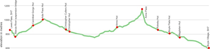
The top of the Lewis Pass to the Boyle River village via the Waiau River.
click to view larger, more interactive topographic map from, err, topomap.co.nz
distance | St James Walkway – North Canterbury
around 65 km
time | St James Walkway – North Canterbury
4 nights, usually, ie, 5 days
when | St James Walkway – North Canterbury
best in summer and autumn, ie, much of the year, the major issue is a slight, but very real, avalanche danger in winter and early spring in the Ada valley. There are signs warning at the locations.
maps and GPS | St James Walkway – North Canterbury
No big deal about maps on this track, if you want a free alternative in the map department you can take a digital photo of the topographical maps that are on display at each roadend and at the huts, and look at your camera when you need clarification to your, or your next destination’s, whereabouts. They have a high enough level of detail.
If that’s not enough there are a few options.
Download free digital versions from LINZ Mapchooser, then you can print off the areas you need yourself.
Or it’s possible to buy the real thing, ie, on old fashioned paper, there’s a couple of detailed options there.
Newtopo.com produces the most useful dead tree map of the St James Walkway at a scale of 1:75,000, available for $9 from major DoC offices and some outdoor stores, Macpac keep them, or consult their website that shows a list of retail outlets. Note that the First edition, 2011, shows the location of the old, burned-down Anne Hut, it has been rebuilt in 2012 800 m to the east.
There are also the Topo50 series maps that cover the country, for the St James you need three, BT23 Lewis Pass, BT24 Ada Flat, and BU 23 Boyle Village, each costing around $7.90 and available at DOC offices, outdoor shops, and bookshops where maps sold. There’s a nationwide list at LINZ Map Retailers.
Need a custom map for your GPS device, download a more compact .klm format file from topomap.co.nz for free, although if you download a few maps consider a small donation, there’s considerable work gone into getting that info onto the internet and we should support these useful resources.
route description | St James Walkway, North Canterbury
Starting at the top of the Lewis Pass the walkway goes over the low Ada Pass towards the Waiau River before returning to State Highway 7 via Anne Saddle and following down the Boyle River to Boyle Village. Note, there’s little in the way of things you might normally expect at a “village” at Boyle Village, ie, no pub, shop, etc.
The Lewis Pass to Boyle direction gives an easier walk over Anne Saddle but the direction is more dictated by transportation possibilities.
For DOC’s version
huts | St James Walkway, North Canterbury
It’s possible to sleep in a serviced hut every night, they are supposed to have firewood supplied, or coal, and have the usual hut features, water, mattresses, and a good roof.
Here are the huts you might encounter on the walkway.
There are also a few in the vicinity that might also be worth a visit:
p((..Lake Guyon Hut
Tramping times | St James Walkway – North Canterbury
Here’s the DoC stated tramping times between huts, as shown on their website, usually actual walking times, ie, not taking into account any long breaks. DoC bases its estimation on times for an “average” tramper which means that it’s possible to slash times for more popular sections. With more remote sections the stated time is close to the actual time required.
Unfortunately, this time information tends to emphasise a pointless aspect of tramping, The Destination, and, some trampers feel they need to test themselves, rush, to prove something to someone. Aren’t you there to experience your environment, notice things, go down to the river and spot a huge trout, and watch the bellbirds flitting around? There’s no actual requirement to occupy the full 10 hours a day racing through the landscape.
Lewis Pass car park – Cannibal Gorge Hut
Time: 3.5 hours
Distance: 7 km
Cannibal Gorge Hut – Ada Pass Hut
Time: 1.5 hours,
Distance: 3 km
Ada Pass Hut – Christopher Hut
Time: 4.5 hours
Distance: 10.5 km
Christopher Hut – Anne Hut
Time: 4.5 hours
Distance:13 km
Anne Hut to the Boyle Flats Hut
Time: 7.5 hours
Distance: 17 km
Boyle Flat Hut to Boyle Settlement
Time: 5 hours
Distance: 14.5 km
getting there | St James Walkway, North Canterbury
You can jump on the East West Coaches bus departing Westport at 8 00 am, arriving Lewis Pass at 10 10 am, or, departing Christchurch at 2 00 pm and arriving at 4 35 pm. Phone 03 789 6251, or 0800 142 622 for further information and pricing.
Getting around by hitching is also possible but, of course, entirely unreliable. There are okay hitching places at both ends of the walkway.
supplies | St James Walkway – North Canterbury
Nelson, Blenheim, and Richmond have the usual major supermarkets, Countdown, New World, Pak’nsave for getting the main supplies. Shellite or Fuelite and gas canisters for your stove can be obtained at outdoor and hardware stores in Nelson or Blenheim, if you haven’t been allowed to fly with it.
From the other direction, Christchurch has the works of course. Hamner Springs has two supermarkets, The Hamner Four Square in Conical Hill Road, open 7 days, most 8:30 am to 6 pm, and the Hamner Springs Foodway in Amuri Avenue open 7 days, 9 am to 5 pm.
warnings | St James Walkway – North Canterbury
All the major streams are bridged although some of the smaller ones need to care to cross after rain.
In spring, or after heavy snowfalls, there is a slight but real avalanche danger. These areas are marked by signage on the trail.
other websites | St James Walkway – North Canterbury
DOC’s version of the walkway.
a big image slideshow | St James Walkway – North Canterbury
Here’s a 39-image slideshow from the St James Walkway giving an indication of the general track conditions and sights along the way, if you need any further convincing.
Click on the thumbnail image below to get the slideshow started, then you can click on the left or right sides of the bigger images to go forward or back.

Images of the St James Walkway huts can be found in the St James Walkway huts section.