The Wangapeka Track was once one of Nelson’s premier tramps, comparable with the Heaphy, and for good reason.
It passes through a variety of scenery, mostly through attractive beech forest, alongside clear mountain streams, and you have a good chance of seeing a rare whio/blue duck, featured on NZ’s $10 note.
It’s mostly benched, ie, often hacked into the granite hillside, wide enough to accommodate your average packhorse.
There’s plenty of history along the way: the track itself was mostly dug out in the 1890s; Cecil Kings Hut was built in 1935 and has been mostly well maintained/restored; there is still the remnants of The Tabernacle, an A-frame shelter built for the track builders and surveyor in 1898; and then there is the legacy of gold mining activity in places.
The huts are well spaced and seldom at capacity. They only cost $5 a night, not the $32 of the nearby Heaphy Track.
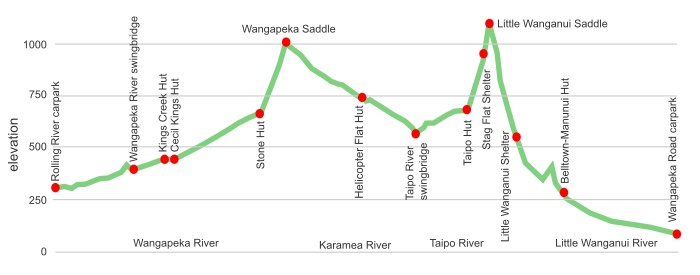
While you have to climb over Wangapeka Saddle, 1009 m, and Little Wanganui Saddle, 1087 m, the track generally has an easy gradient.
The Wangapeka is not as inundated with people as the more highly manicured Heaphy Track.
So, why ain’t it more popular?
Getting to or from the Tapawera end of the trail, the east side, requires ingenuity and/or expense. The road from Tapawera is not often used although it also services the more popular Mt Owen track. Accessing the Little Wanganui end, the west, is much easier.
There’s a few slips that wipe out short stretches of the track periodically after heavy rain.
The Wangapeka, Karamea and Little Wanganui Rivers have swing bridges but there are a number of streams that are not bridged and may become impassable for a few hours during that heavy rain period.
The huts, while comfortable enough, are rundown in comparison with others on similar named tracks. You get the feeling the track has been abandoned by DOC.
Overall it’s a great introduction to tramping if you want to do something more adventurous, less populated and cheaper than the Great Walks.
where | Wangapeka Track, Kahurangi National Park
Little Wanganui carpark 20km south of Karamea to the Rolling River carpark in the Wangapeka River valley,
click to view larger, more interactive topographic map from, err, topomap.co.nz
distance | Wangapeka Track, Kahurangi National Park
59 km one way, Rolling River carpark in the east to the Wangapeka Road carpark in the west
time | Wangapeka Track, Kahurangi National Park
4 or 5 days
when | Wangapeka Track, Kahurangi National Park
Anytime but probably best when there are longer and warmer days, ie, the summer months, November to April.
Occasionally there may be snow in winter on Little Wanganui or Wangapeka Saddle but it seldom lasts long.
maps and GPS | Wangapeka Track, Kahurangi National Park
Because the track is so well marked, both with signage along the way and the clarity of the path, you can probably get away with the map found on DOC’s Wangapeka Track information pamphlet which you can download.
If you are going to be heading off the track for whatever reason, zipping over Biggs Tops to Trevor Carter Hut for instance, maps can be found at Land Information New Zealand, LINZ, Topo50 maps, both digital and paper: BQ24 Tapawera, just the first kilometre, BQ23 Wangapeka Saddle and BQ22 Karamea.
Download free digital versions from LINZ Mapchooser, or buy the real thing, ie, on old fashioned paper, at DOC offices, outdoor shops and bookshops where maps sold. There’s a nationwide list at LINZ Map Retailers.
Need a custom map for your GPS device, download a more compact .klm format file from topomap.co.nz for free, although if you download a few maps consider a small donation, there’s considerable work gone into getting that info onto the internet and we should support these useful resources.
route description | Wangapeka Track, Kahurangi National Park
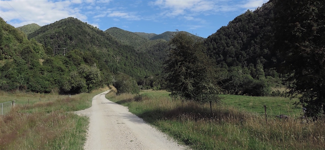
From the east the Rolling River carpark is 13 km from Tadmor on a mostly gravel road. The Wangapeka follows up the river, that the, err, Wangapeka River with a increasingly steeper climb to Wangapeka Saddle, 1009 m, mostly in forest, the descends the upper Karamea River, crossing a few creeks along the way to the swingbridge over the Taipo River. Then there is a slow climb to the Little Wanganui Saddle, 1087 m, the short last section up from Stag Flat is the steepest of the trip, then it’s downhill most of the way to the Wangapeka Road carpark.
From the west the start is at the Little Wanganui carpark, also the launch of the Leslie-Karamea Track. Turn off the main Karamea road at Te Namu, 10km south of Karamea on Wangapeka Road, it’s another 10km along an unsealed road to the termination at the carpark.
The DOC Wangapeka Track website has fairly extensive information, including brief track notes from hut to hut.

huts and campsites | Wangapeka Track, Kahurangi National Park
There are 8 huts or shelters along the track.
Note that Belltown Manunui Hut has been relocated 20 minutes downstream and is now closer to the Lawrence Stream swingbridge.
There’s also the Siberia Flat campsite just near the Rolling River carpark.
Tramping times | Leslie-Karamea Track – Kahurangi National Park
Here’s the DoC stated tramping times between huts, as shown on their website, usually actual walking times, ie, not taking into account any long breaks. DoC bases its estimation on times for an “average” tramper, which means it’s possible to slash times for more popular sections. With more remote sections, the stated time is close to the actual time required.
Unfortunately, this time information tends to emphasise a pointless aspect of tramping, The Destination, and some trampers feel they need to test themselves, rush, to prove something to someone. Aren’t you there to experience your environment, notice things, go down to the river, spot a huge trout, and watch the bellbirds flit around? There’s no requirement to spend 10 hours a day racing through the landscape.
Rolling River carpark to Kings Creek Hut
Time: 3 hours 30 minutes
Distance: 11.4 km
Kings Creek Hut to Cecil King Hut
Time: 5 minutes
Distance: 0.4 km
Cecil King Hut to Stone Hut
Time: 2 hours 30 minutes
Distance: 7.9 km
Stone Hut to Helicopter Flat Hut
Time: 4 hours
Distance: 10.4 km
Helicopter Flat Hut to Taipo Hut
Time: 3 hours 30 minutes
Distance: 8.6 km
Taipo Hut to Belltown-Manunui Hut
Time: 6 hours 30 minutes
Distance: 10.2 km
Belltown-Manunui Hut to Wangapeka roadend, West Coast
Time: 3 hours
Distance: 10 km
getting there | Wangapeka Track, Kahurangi National Park
If you can be dropped off at the Rolling River carpark, what’s the problem? Hitching is possible but the probability of an extra 10 or 13k trudge at either end is high.
Using public transport: it’s probably easier to start from the more remote West Coast side. There’s an early morning, 7:15am, seven day a week Intercity bus, $36, from Nelson to Westport that can connect with the Karamea Express bus (03-782 6757; info@karamea-express.co.nz) to, err, Karamea that will drop you off at the Little Wanganui carpark for $45 a person by 1.00pm, just enough time to make it up to Belltown Manunui Hut before dark, ie, you can get from Nelson to the first hut, a three hour walk, in a day. That’s useful.
Groups can use Nelson Lakes Shuttles, www.nelsonlakesshuttles.co.nz/prices.html, a charter minibus is $95 per person, with a minimum $380 charge, with 48 hours notice.
Alternatively, Trek Express, www.trekexpress.co.nz/prices.html offers Nelson to Little Wanganui carpark for $115, minimum 4 people, or Nelson to Rolling River carpark for $50, also minimum 4 trampers. They do have scheduled trips you can join where you only pay the per person price, mostly used by those on the Heaphy Track but Trek will drop you off along the way for the same price.
There’s no regular public transport to the Rolling River carpark. This road is an almost popular tourist spot, you might be able to pick up a ride from day trippers heading up Mt Owen for the day. If not its a 13 km walk down from the carpark to a busier road at Tadmor.
Rolling River carpark access: groups can use Trek or Nelson Lakes Shuttles, they are now owned by the same company, might be an affordable charter $50 per person (min $200 charge). Trek Express have some scheduled trips, trekexpress.co.nz/trips.html, to Rolling River.
supplies | Wangapeka Track, Kahurangi National Park
Nelson, Richmond or Westport have the usual major supermarkets, either Countdown, New World, Pak’n‘save, for getting the main supplies. Gas canisters, Shellite or Fuelite for your stove can be obtained at outdoor and hardware stores if you haven’t been allowed to fly with it.
Karamea has a small Four Square supermarket that has most of the basics, open 7 days from 8:30 am weekdays, 9am weekends.
warnings | Wangapeka Track, Kahurangi National Park
The Wangapeka isn’t as flood proof as some other tracks around, care needs to be taken when crossing the creeks without swing bridges after heavy rain. These steep creeks do drop very quickly when the rain stops, best not to be impatient.
The slips in the upper Karamea, and near Rolling River can also be an issue after heavy rain where new loose material may move down the slope and cover the track.
The extensive windfalls resulting from very strong winds in April 2014 on the West Coast side have been dealt with by DOC, this is no longer an issue.
Yeah, it’s mostly the creeks that are the issue with this track.
other websites | Wangapeka Track, Kahurangi National Park
DOC has the Wangapeka Track website and downloadable brochure.
a big image slideshow | Wangapeka Track, Kahurangi National Park
Here’s a 50 image slideshow from the Wangapeka Track giving an indication of the general track conditions and sights along the way, if you need any further convincing.
Click on the thumbnail image below to get the slideshow started, then you can click on the left or right sides of the bigger images to go forward or back.
Images of the Wangapeka Track huts can be found in the other Kahurangi huts section.
