For those who feel that Stewart Island’s Southern Circuit is not sufficiently arduous and demanding, and that would be a tiny subset of the population, there’s always the Tin Range route over to Port Pegasus for the full New Zealand tramping experience.
No track, no huts, no route on the map.
If that’s your thing this route will take you as far south as you can go in New Zealand before resorting to just plain old-fashioned scrub bashing.
The disincentives:
the Land Information New Zealand Topo 50 series maps fail to indicate the route;
there are no official DOC track markers, you follow a vague trail on the ground, supplemented by the occasional single rock on end, and various twigs poked in the soft ground, it is way easy to find yourself bamboozled, particularly in poor weather;
the track is fully overgrown for some significant sections through dense manuka and olearia scrub, necessitating a full body wrestle with your pack as you shove, haul, grunt, mutter and generally exhaust yourself all the time thinking, I hope this is the actual track;
the weather at 47º S is immensely variable, gales and gloomy one day, unspeakably gorgeous the next;
you spend considerable time once you have struggled your way onto the tops trudging over that particular alpine herbage with excessive sponginess;
oh, and not forgetting for those intent on walking just the one way the cost of the boat trip to Port Pegasus is in no way insignificant, there’s plenty of open sea travel that is fully exposed to the Great Southern Ocean and a substantial boat is required.
Are you convinced yet?
With this effort there is considerable payoff — the view from Hill 637 is one of the most thrilling in New Zealand, Table Hill ain’t bad either.
You look over to one of the most remote areas in the country, the islands in Port Pegasus, the various granite domes, Lees Knob, round to Gog, Magog is relatively insignificant, the Titi islands off the west coast, down to the southernmost hills of Stewart Island, but also you get Doughboy, the Ruggedy Range, Codfish/Whenau Hou, Mt Rakeahua and Mt Anglem/Hananui all discernible on a fine day, and way in the distance the Catlins and the snowy peaks of Fiordland.
Wow, like super wow.
The obvious warnings:
It might only be around 30 km each way but this route is only for well-equipped, ie, overtrou, gaiters, leather gloves, etc, to avoid a good twigging, with maps, GPS, and ELB, with a high level of fitness and a major level of track finding experience in New Zealand.
Come off the route here and that is easy to do, and you may find yourself bush bashing through dense scrub for weeks.
Despite the relative short length this is a demanding tramp suitable only for those experienced in route finding in New Zealand conditions. More than half the distance is above the scrub line along ridges, and conditions fully exposed to the brunt of weather at 47° S, it can be wet, windy, and fully confusing on the flat ridges, even when visibility is adequate.
A hugely inspiring trip, demanding a high level of route finding skills and major scrub bashing enthusiasms, it sure ain’t easy work.
where | Tin Range route, Stewart Island/Rakiura
The Tin Range is the most southern tramping route in New Zealand. (Okay, there’s a lightly marked route to Gog a little further south but you need to charter a boat to get there, or scrub bash for a few days.)
The northern end starts from the Rakeahua Valley and heads south to either Diprose Bay or North Arm at Port Pegasus.
click to view larger, more interactive topographic map from, err, topomap.co.nz
distance | Tin Range route, Stewart Island/Rakiura
27 km one way, + 2 km to Rakeahua Hut
time | Tin Range route, Stewart Island/Rakiura
2 days, each with around 6—7 hours walking, the scrub bashing takes time.
Possible to do in one immense 14 hour day, that’s actual walking time, but what’s the point.
when | Tin Range route, Stewart Island/Rakiura
Anytime the weather is good but probably best when there are longer days, ie, the summer months, November to April.
maps and GPS | Tin Range route, Stewart Island/Rakiura
It’s essential to have a paper map in case GPS batteries die.
Land Information New Zealand, LINZ, Topo50 maps, both digital and paper: CJ08 Doughboy Bay, CJ09 Mount Allen.
Download free digital versions from LINZ Mapchooser, or buy the real thing, ie, on old fashioned paper, at DOC offices, outdoor shops and bookshops where maps sold. There’s a nationwide list at LINZ Map Retailers.
Need a custom map for your GPS device, download a more compact .klm format file from topomap.co.nz for free, although if you download a few maps consider a small donation, there’s considerable work gone into getting that info onto the internet and we should support these useful resources.
route description | Tin Range route, Stewart Island/Rakiura
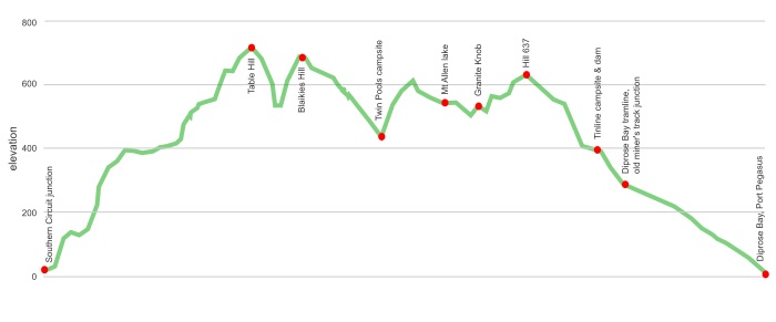
Heading south you start by turning off the Southern Circuit a couple of kilometres west of Rakeahua Hut with a 700 m climb that takes you through typical Stewart Island podocarp forest, there is a vague track used by DOC staff for predator control for the highly endangered southern dotterel breeding areas, a few orange ribbons to follow that soon turns into a completely unmarked and excessively overgrown crash through manuka and olearia scrub. A foot track is often visible but it’s the full body experience, pushing, swimming through the scrub to the bush line around 500 m. There are occasional snow pole markers to the top of Table Hill, after that there are semi-regular markers of the most vague kind, short lengths of olearia punched into the semi-spongy herbland, and rocks that have been upended, that may or may not be indicating the route. It ain’t easy to follow
That state continues for about 15 km, along the rounded ridgelines. The major hint for route finding is to avoid the main Mount Allen ridgeline, instead staying to the east and crossing a substantial creek, then climbing to the tarn under Mount Allen and re-joining the main ridgeline near Granite Knob.
It’s straightforward to descend westwards before the southern end of the southern end of the Tin Range ridge, there’s three closely spaced snow post to indicate the point, down to a considerable stone dam, built for the 1900 era tin mines and then joined the old tramline to get to Diprose Bay, or, alternatively branch off on an old miner’s track that leads down to the more boat accessible North Arm cove. Yeah, that’s Port Pegasus. From the shoreline it’s a surprise to look across to the concrete retaining wall where a fish processing factory once stood. And those mussels and rock oysters, bountiful at low tide, are delicious.
huts and campsites | Tin Range route, Stewart Island/Rakiura
There are no huts along the route. Rakeahua Hut on the Southern Circuit is near the northern end.
There are few places that meet the criteria for acceptable camping, ie, water and two of: almost level ground, protected from the wind, un-lumpy. The small Twin Pools area is the most conveniently located, the halfway point. The Tramline Dam is the only campsite which offers all three amenities.
Mt Allen Lake, north end campsite
Mt Allen Lake, south end campsite
North Arm campsite, Port Pegasus
Twin Pools campsite, Kopeka River
getting there | Tin Range route, Stewart Island/Rakiura
Here’s a suggestion: take the ferry across to build up the suspense and then fly back when you can identify where you have been from the air. And you then won’t have to worry about the 15 kg baggage limit.
Flying: Three flights a day, at slightly varying times depending on the season, 365 days a year, from Invercargill airport to the strip on Stewart Island. The flight takes 20 minutes and can give a good overview of the island. There’s a minibus to take passengers to/from the Oban Post Office which is included in the fare. Fares: adult return $220, one way $130, with a variety of others depending on passenger’s age. Baggage limit: 15 kg, now that’s a problem when you are heading to the island because you really need to travel with all your kilos of food. Phone Stewart Island Flights on 03 218 9129.
Ferry: The express catamaran ferry is now owned by Real Journeys which has connecting buses to Invercargill, Queenstown and Te Anau. The trip takes about one hour from Bluff to Oban. There’s daily ferries, with more than one on many days but it’s a mighty complicated schedule and fare structure, either $112 adult one way from Invercargill to Stewart Island.
That get you to Oban. From there you can either walk around to Rakeahua Hut, and walk back if you have time or grab one of the numerous water taxis to either Freds Camp Hut or all the way to Rakeahua Hut, that’s quite tidal. Stewart Island Water Taxis will take you to Freds Camp for $50 a person, $70 minimum, or Rakeahua Landing, 5 minutes from the hut, for $65 per person, $100 minimum.
To get to Port Pegasus requires a bigger boat, you are out on the open sea and it is a long way, around 120 km return for the boat owner. Aurora Charters will take you there on one of their scheduled trips in January and February for $180 per person, or you can charter their boat for your own expedition for a rather expensive $1900.
Helicopters? Maybe, but there is no obvious place for them to land at Port Pegasus.
supplies | Tin Range route, Stewart Island/Rakiura
Invercargill, population 53,000, has the usual major supermarkets, Countdown, New World, Pak’n‘save for getting the main supplies. Shellite or Fuelite for your stove can be obtained at outdoor and hardware stores if you haven’t been allowed to fly with it.
The small store, Ship to Shore Four Square supermarket, at Oban, population around 400, usually has a reasonable, if expensive, supply of food and basic camping needs, matches, candles, gas canisters, etc, and operates normal business hours, seven days a week. Buying all supplies in Invercargill makes huge sense.
warnings | Tin Range, Stewart Island
Necessary luggage includes a set of maps for the full route, and a GPS to show where you are located. Note that the LINZ maps do not indicate the route. It is useful to upload a .kml file for the track to your GPS unit.
The route is not entirely obvious for a few reasons.
The track is not shown on LINZ Topo50 maps.
DOC has removed all official markers, except for a few snow poles above the scrub line to the top of Table Hill.
The route is therefore unmarked in the forest, although it is possible to guess the route if you have done this sort of off track route finding before.
The route has not been maintained by DOC since at least 2004.
The manuka and leatherwood shrubbery have often completely overgrown parts of the route.
The tops are broad and it is sometimes confusing where to proceed. This would be a major issue when visibility is poor, ie, much of the time.
The route avoids the main Mt Allen ridge and is located to the east.
An emergency locator beacon is essential equipment here. Few parties use this route in any year and you are a long way from any help. This is about as remote as you can get in New Zealand tramping.
The dense manuka and leatherwood scrub makes travel extremely physical, and twigs can majorly scratch up exposed skin. Tough overtrou and gaiters are sensible to protect the lower limbs.
Finally, despite the low heights attained, ie, around 700 m, this is an entirely exposed route, the scrubline is below 500 m for the most part so 25 km is along the tops, fully in the way of severe Roaring Forties winds.
This is not a tramp for people inexperienced in route finding or New Zealand conditions in general. DOC does not encourage use of the route.
other websites | Tin Range route, Stewart Island/Rakiura
DOC do not promote this tramp, and are able to provide little information about it.
a big image slideshow | Tin Range route, Stewart Island/Rakiura
Here’s a 50, err, 51, image slideshow from the Tin Range route giving an indication of the general track conditions and sights along the way, if you need any further convincing.
Click on the thumbnail image below to get the slideshow started, then you can click on the left or right sides of the bigger images to go forward or back.

Images of the Tin Range campsites can be found in the Rakiura/Stewart Island huts and campsites section.