The historic cattle track was originally built in 1875 to take cattle from the pastures of the Haast/Landsborough and Cascade River valleys to market north of Paringa. It was used for around 90 years until the Haast Pass Highway was completed, making it redundant, even though the track had been widened over the years.
90% of it is super easy walking, those cattle like a decent path, and the rest, well, it isn’t. Parts have been washed out, and those sections can test your average tramper.
The track travels through some very typical West Coast forest, complete with moss, ferns, and larger beech and podocarp trees.
And some ascent is involved with Maori Saddle at 1000 m, but the gradient on the original track is always moderate. The washouts are not.
So, for 90% of the way this is an easy mountain bike ride, or for families. The other 10% means that it is clearly not. See warnings further on.
However, it is a great introduction to South Westland for those who like just a taste of adventure in their lives.
where | Haast Paringa Cattle Track, South Westland
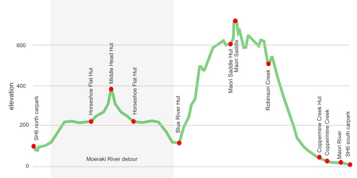
From carpark on Highway SH6 in the north over Maori Saddle to the south SH6 carpark. Easier to go north to south
click to view larger, more interactive topographic map from, err, topomap.co.nz
distance | Haast Paringa Cattle Track, South Westland
33 km, north SH6 carpark to south SH6 carpark.
Add 11 km each way for cruising up to Middle Head Hut in the Moeraki River valley.
time | Haast Paringa Cattle Track, South Westland
4 days if you stay at each hut. First and last days are short. Maori Saddle Hut to Coppermine Creek Hut is a nine hour day.
when | Haast Paringa Cattle Track, South Westland
Anytime the weather is good, but probably best when there are longer days, ie, the summer months, November to April.
Okay, in winter as there are no mountains to produce avalanches, and the two main rivers, Blue and Maori Rivers, have bridges. You are on your own with the creeks.
maps and GPS | Haast Paringa Cattle Track, South Westland
It’s useful to have a paper map in case GPS batteries die.
Land Information New Zealand, LINZ, Topo50 maps, both digital and paper: BY12 Haast, and BY13 Lake Paringa.
Download free digital versions from LINZ Mapchooser page 21, or buy the real thing, ie, on old fashioned paper, at DOC offices, outdoor shops and bookshops where maps sold. There’s a nationwide list at LINZ Map Retailers.
Need a custom map for your GPS device, download a more compact .klm format file from topomap.co.nz for free, although if you download a few maps consider a small donation, there’s considerable work gone into getting that info onto the internet and we should support these useful resources.
route description | Haast Paringa Cattle Track, South Westland
Easy walking from the north carpark to Blue River Hut. Then it is a steady climb to Maori Saddle Hut. You mostly head down hill to Coppermine Creek Hut, but there are some big washouts, particularly Mackenzie Creek, that slows you down. The walk out is flat, but somewhat lumpy and at times boggy underfoot.
huts | Haast Paringa Cattle Track, South Westland
Blue River Hut is fairly popular, due to the proximity to the road, and people pop in for the weekend. Maori Saddle Hut is not much visited at all.
Finding other campsites is not so easy, due to the prevalent crown fern and generally damp ground conditions.
If you venture up the Moeraki River valley there are two more huts:
tramping times | Haast Paringa Cattle Track, South Westland
Here’s the DOC stated tramping times between huts, as shown on their website, usually actual walking times, ie, not taking into account any long breaks. DOC bases its estimation on times for an “average” tramper, which means that it’s possible to walk somewhat faster. On this track there is considerable variation between the stated DOC times and what it would actually take, usually less. Some are way out, others close.
Unfortunately this time information tends to emphasise a pointless aspect of tramping, The Destination, and, some trampers feel they need to test themselves, rush, to prove something to someone. Aren’t you there to experience your environment, notice things, experience the views, watch the bellbirds flitting around? There’s no actual requirement to minimise the time racing through this memorable landscape.
north carpark to Blue River Hut
Time: 2 hours
Distance: 3 km
Blue River Hut to Maori Saddle Hut
Time: 6 hours
Distance: 9 km
Maori Saddle Hut to Coppermine Creek Hut
Time: 9 hours (That’s what the DOC sign says, and it’s not ridiculous.)
Distance: 15 km
Coppermine Creek Hut to south carpark
Time: 2 hours
Distance: 6 km
Also, if you head up the Moeraki River valley. Remember it’s the same times back!!
Haast Paring Cattle Track turnoff to Horseshoe Flat Hut
Time: 3 hours
Distance: 7 km
Horseshoe Flat Hut to Middle Head Hut
Time: 2 hours
Distance: 4 km
getting there | Haast Paringa Cattle Track, South Westland
The Intercity bus from Fox Glacier to Queenstown can drop you off at either of the carparks, but they are not official stops. They can also pick you up if you have made prior arrangements. Maybe.
Both carparks are right on the road. There is a surprising amount of tourist traffic on the road so it is possible to hitch hike between the carparks.
supplies | Haast Paringa Cattle Track, South Westland
Fox Glacier has a small supermarket, open 7 days, 8 am — 7 pm. Haast Beach is similar.
Advisable to get complete supplies in Queenstown, Wanaka, Hokitika, or Greymouth where there are national supermarkets and pricing.
warnings | Haast Paringa Cattle Track, South Westland
Despite the generally cruisy nature of the track, occasionally trampers have turned back at Chasm Creek, not far from Maori Saddle, where you are required to negotiate a potentially slippery, sloping rock path with some exposure to a fall, maybe 12 m.
It looks more perilous from a distance, slightly better up close, but in fact there is nothing to hang onto.
Sure gets the adrenaline pumping for your average tramper. This is what makes it a less than family friendly track.
The massive Robinson Creek washout is different. Despite DOC suggesting it has been re-marked, it is not clear exactly where the track goes. The eagle eyed will spot a large orange DOC marker high above a couple of big slips way in the distance as they make their way down to the creek. The track begins at the top of the second slip.
You mean up there??!!
The day from Maori Saddle Hut to Coppermine Creek Hut is fairly long. DOC signage states nine hours, and the enthusiastic may trim something off that. The inexperienced may find they waste time at Robinson Creek, and the day is slipping by.
Coppermine Creek Hut is fairly notorious for mosquitoes judging by comments in the hut book. Recommended to take some form of defence, like mosquito coils, or even a can of fly spray. That can make all the difference for a good night’s sleep. The hut book tells tales of people pitching their tent in the middle of the night, or walking out to their car at 2 am to escape the buzzing.
The deep Blue and Maori Rivers have bridges, but most of the other streams do not. The steepness of the streams coming off the range means that immediately following a heavy downpour these may be impassable, but similarly it doesn’t take long after the rain has stopped for them to be able to be crossed with due care.
The track up to Horseshoe Bend Hut crosses only small streams, but the walk on to Middle Head Hut requires two crossings of the Moeraki River. This can come up quickly after heavy rain and become impassible.
Pretty obvious that there is no cell phone coverage. Closest is within 3 km of Haast.
other websites | Haast Paringa Cattle Track, South Westland
DOC has a webpage for the Haast Paringa Cattle Track., but it doesn’t tell you much.
My blog, that included a trip up to Middle Head Hut starts here.
a big image slideshow | Haast Paringa Cattle Track, South Westland
Here’s a 36 image slideshow from the Haast Paringa Cattle Track, including some up the Moeraki River valley, giving an indication of the general track conditions and sights along the way, if you need any further convincing.
Sorry they aren’t in order for some reason, but I’m working on it.
Click on the thumbnail image below to get the slideshow started, then you can click on the left or right sides of the bigger images to go forward or back.

Images of the Haast Paringa Cattle Track huts can be found in the West Coast huts and bivvys section.