The Karamea Valley is a major treat to walk down. The beech forest is picturesque, dripping in places with Old Man’s Beard, and the clear green water is spectacular. Those monster trout just hover, barely sinusoidal, and if you are observant you may see 20 or more in the Karamea River. Whio/blue ducks are also around, listen for the male’s whistle. There’s evidence on show of the massive 1929 Murchison earthquake in the hills around Trevor Carter Hut. Then Moonstone Lake created at that time by a humungous slip. Further down you wander past huge rimu and matai trees.
So, plenty of visual interest, a relatively easy walk, mostly down a forested river valley, although there are also a couple of above-the-treeline stretches. Good, if not great, accommodation in often newish huts. The creeks usually offering the swingbridge, rather than the wet feet, alternative. Not so much in the way of serious hill climbing, and, somewhat surprisingly, not so many others out on what could, should, be a well-utilised track.
And it’s all relatively accessible from Nelson or Westport, if you get organised with the transportation. You gotta love it.
where | Leslie-Karamea Track – Kahurangi National Park
Little Wanganui carpark 20 km south of Karamea, to Flora carpark, 20 km south of Motueka, basically through the heart of Kahurangi National Park, although it’s also possible to pop out the Wangapeka Track near Tapawera.
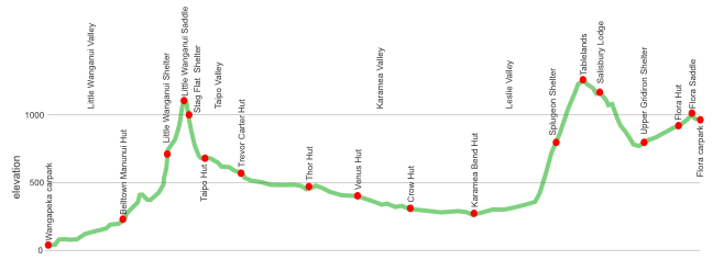
click to view larger, more interactive topographic map from, err, topomap.co.nz
distance | Leslie-Karamea Track – Kahurangi National Park
91 km
time | Leslie-Karamea Track – Kahurangi National Park
6 – 9 days
when | Leslie-Karamea Track – Kahurangi National Park
Anytime?
Sure thing. The climate around Karamea is reasonable mild all year. Okay, the Karamea valley is potentially frosty in winter and there can be a freak snow storm at any time of the year but we are a tough lot. As they say: ain’t no big thing.
There’s no major passes to get over, Little Wanganui Pass hardly rates at 1087 m, the highest point, umm, rounded bump, on the Tablelands is a big 1260 m. And it’s a well benched track, an old packtrack, often forested, both up from the Leslie and down to Flora. The bigger rivers and most of the major creek crossings have a swingbridge, the main exception is Kendell Creek but that is close to Trevor Carter Hut or Thor Hut, decent places to hang out the hours it takes for the creek to go back down.
maps and GPS | Leslie-Karamea Track – Kahurangi National Park
It’s useful to have a paper map in case GPS batteries die.
Land Information New Zealand, LINZ, Topo50 maps, both digital and paper: BQ22 – Karamea, BQ23 – Wangapeka Saddle, BQ24 – Tapawera and a small section of BP24 – Takaka.
Download free digital versions from LINZ Mapchooser and print out your own, or buy the real thing, ie, on old fashioned paper, at DOC offices, outdoor shops and bookshops where maps sold. There’s a nationwide list at LINZ Map Retailers.
Need a custom map for your GPS device, download a more compact .klm format file from topomap.co.nz for free, although if you download a few maps consider a small donation, there’s considerable work gone into getting that info onto the internet and we should support these useful resources.
route description | Leslie-Karamea Track – Kahurangi National Park
From the west the start is at the Little Wanganui carpark, also the launch of the Wangapeka Track. Turn off the main Karamea road at Te Namu, 10 km south of Karamea on Wangapeka Road, it’s another 10 km along an unsealed road to the termination at the carpark.
The route follow the Little Wanganui River upstream to Little Wanganui Saddle, 1087 m, down the Taipo and Karamea Rivers, then up the Leslie River onto the Tablelands and in behind Mt Arthur.
From the east the Flora carpark is up the Graham Valley South Branch Road, which has been closed off and on due to a major slip.
The DOC Leslie-Karamea track description site has fairly extensive information, including brief track notes from hut to hut.
huts | Leslie-Karamea Track – Kahurangi National Park
Here’s the huts:
Tramping times | Leslie-Karamea Track – Kahurangi National Park
Here’s the DOC stated tramping times between huts, as shown on their website, usually actual walking times, ie, not taking into account any long breaks. DoC bases its estimation on times for an “average” tramper which means that it’s possible to slash times for more popular sections. With more remote sections the stated time is close to the actual time required.
Unfortunately this time information tends to emphasise a pointless aspect of tramping, The Destination, and, some trampers feel they need to test themselves, rush, to prove something to someone. Aren’t you there to experience your environment, notice things, go down to the river and spot a huge trout, watch the bellbirds flitting around? There’s no actual requirement to occupy the full 10 hours a day racing through the landscape.
Wangapeka roadend, West Coast to Belltown-Manunui Hut
Time: 3 hours
Distance: 10 km
Belltown-Manunui Hut to Taipo Hut
Time: 6 hours 30 minutes
Distance: 10.2 km
Taipo Hut to Trevor Carter Hut
Time: 2 hours 30 minutes
Distance: ~8 km
Trevor Carter Hut to Thor Hut
Time: 3 hours 30 minutes
Distance: 9.5 km
Thor Hut to Venus Hut
Time: 2 hours
Distance: 5.7 km
Venus Hut to Crow Hut
Time: 2 hours
Distance: 5.9 km
Crow Hut to Karamea Bend Hut
Time: 3 hours 30 minutes
Distance: 9.7 km
Karamea Bend Hut to Salisbury Lodge
Time: 6 hours
Distance: 18 km
Salisbury Lodge to Flora car park
Time: 4 hours 30 minutes
Distance: 13.2 km
getting there | Leslie-Karamea Track – Kahurangi National Park
Can be dropped off, what’s the problem? Hitching is possible but the probability of an extra 10 km trudge at either end is high.
Unfortunately, the regularity of the various companies and routes has not yet settled back to what was once available pre-Covid in early 2020. Hopefully we will return to plenty of choice soon.
Using public transport: it’s probably easier to start from the more remote West Coast side. There’s an early morning, 7 15 am, three day a week Intercity bus, $36, from Nelson to Westport that can connect with the Karamea Express bus (03-782 6757; info@karamea-express.co.nz) to, err, Karamea that will drop you off at the Little Wanganui carpark for another $45 a person by 1 00 pm, just enough time to make it up to Belltown Manunui Hut before dark, ie, you can get from Nelson to the first hut, a three-hour walk, in a day. That’s useful.
The Heaphy Bus can drop you off. Check website for schedule.
Groups can use Nelson Lakes Shuttles, a charter minibus is $95 per person, with a minimum $380 charge, with 24 hours notice. They also may have some scheduled times.
Alternatively, Trek Express offers Nelson to Little Wanganui carpark for $115 each, minimum 4 people, or Nelson to Flora carpark for $45, also minimum 4 trampers. They do have scheduled trips you can join where you only pay the per person price, mostly used by those on the Heaphy Track but Trek will drop you off along the way for the same price.
Exiting via the West Coast there is a public phone box about 500 m down the road from the Little Wanganui carpark, that’s if you have someone to call.
There’s no regular public transport to the Flora carpark. There is a public phone box, if you have someone to ring. Flora is a popular tourist spot, when it’s not officially closed due to a major slip on the access road, and you might be able to pick up a ride down the hill from day trippers heading up Mt Arthur for the day. Weekends are busy, but there’s quite a few people up there all the time. If not there’s a 10 km walk down from the 975 m carpark to a busier road.
Flora carpark access: groups can use Trek or Nelson Lakes Shuttles, they are now owned by the same company, might be an affordable charter $45 per person (min $180 charge).
supplies | Leslie-Karamea Track – Kahurangi National Park
Nelson, Motueka or Westport have the usual major supermarkets, Countdown, New World, Pak’nsave, for getting the main supplies. Gas canisters, Shellite or Fuelite for your stove can be obtained at outdoor and hardware stores if you haven’t been allowed to fly with it.
warnings | Leslie-Karamea Track – Kahurangi National Park
There are two usual ways to get into difficulties on the Leslie-Karamea. This is a very high rainfall area so rivers and creeks get up quickly after a deluge. Snow isn’t common, but it is possible to fall at any time of the year, more usually in mid-winter, July/August.
Many creeks are bridged or avoided, the main area with concerns is between Trevor Carter and Thor Huts. Kendall Creek is a large tributary to the Karamea River and there is no swingbridge. In periods of little rain it can be avoided by heading north on the true right side of the Karamea River and crossing the main river a few kilometres downstream. After rain, well, you are not going to get across Kendall Creek, you will need to wait it out.
There’s also a potentially problemmatic section of track between Thor and Venus Huts which is very close to the Karamea River, you walk on greasy rock immediately above the water, clutching a thick stainless steel rope that has been installed by DOC. If the river is way up this zone of a few hundred metres may be impassable. Any other unabridged streams will rise quickly, but then fall quickly as well. If the weather forecast is poor it may be better to stay put for a day.
If there has been thick snow care will be required in getting across Little Wanganui Saddle. There are some steep sections but the actual area not in forest is quite short. Snow poles painted Rescue Orange indicate the route. There is a more substantial open area when getting up to The Tablelands, in behind Salisbury Lodge. This is slightly higher than Little Wanganui Saddle but being an old pack track, built for horses, there are few concerns, although there are a couple of avalanche paths to cross just before getting out into the open. The track over The Tablelands is well marked with those brightly coloured snow poles.
other websites | Leslie-Karamea Track – Kahurangi National Park
DOC also have a 1.2 Mb pdf blurb about the Leslie-Karamea complete with a map and track description.
a big image slideshow | Leslie-Karamea Track – Kahurangi National Park
Here’s a 38 image slideshow from the Leslie-Karamea giving an indication of the general track conditions and sights along the way, if you need any further convincing.
Click on the thumbnail image below to get the slideshow started, then you can click on the left or right sides of the bigger images to go forward or back.

Images of the Leslie-Karamea huts can be found in the other Kahurangi huts section.
An additional 11 images can be found on the blog pages, one image a day.