Generally good weather, easy walking on old farming or cattle tracks, no trees to spoil the view. And it’s exciting country. There is plenty of landscape on display.
This East West route is different from many other long tramps in the South Island.
Yup, and great, well spaced huts, that have few occupants.
If you want to get away from other trampers while generally cruising up or down valleys, this is a great option.
It does have its moments like:
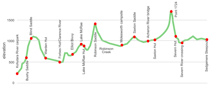
the first day climbing up to Blind Saddle, an almost 1000 m grunt;
crossing the Clarence River, so good you are required to do it three times in a kilometre;
climbing over the 1420 m Robinson Saddle;
or the stretch between Saxton and Severn Huts, Point 1764 is involved there.
There are some historic huts along the way: Tent Poles, Black Spur, Bluff Dump, and the Quail Flat and Molesworth Cob Cottages.
For the energetic there is the possibility of adding in a loop of the Leatham/Molesworth route, and/or extending over to include half the St James Walkway and ending at Boyle Village near the Lewis Pass. That can make it into a full 212 km excursion, from Kohutara to Boyle Village.
There are generally no markers, okay, there are about six in total, hence the “route” designation. Often you just follow cattle tracks through the matagouri/briar prickles. Plenty of un-bridged river/creek crossings. A few big climbs.
Yeah, this is a good trip for long-legged loners who like to cover terrain without tree roots, trees themselves, or other trampers.
where | East West route, Marlborough
From Kohutara River carpark, 25 km from Kaikoura on the Inland Road, to Sedgemere Sleepout on the Rainbow Road that runs from near St Arnaud to Hamner.
click to view larger, more interactive topographic map from, err, topomap.co.nz
distance | East West route, Marlborough
115 km, Kahutara to Sedgemere Sleepout
time | East West route, Marlborough
6—7 days
when | East West route, Marlborough
Anytime the weather is good, but probably best when there are longer days, ie, the summer months, November to April.
The main issue is crossing the Clarence River, or Saxton or Severn Rivers if they are in flood. Spring to early summer has a greater volume of water due to snow melt.
In winter there may be snow and/or ice, particularly on the mountain passes, ie, 1420 m Robinson Pass, or Point 1764, err, that’s 1764 m.
maps and GPS | East West route, Marlborough
It’s useful to have a paper map in case GPS batteries die.
Land Information New Zealand, LINZ, Topo50 maps, both digital and paper: BT27 Kaikoura, BT26 Mount Clear, BS26 Mount Muller, BS25 Severn. You need all four to cover the complete track from Kohutara carpark to Sedgemere sleepout. There is not much on the Kaikoura one but it does show the start of the track, which is useful. Note that the printed map version, Edition 1.02, published 2013, does not show the start of the track correctly. The online map has been updated correctly.
Download free digital versions from LINZ Mapchooser page 19 and page 18, or buy the real thing, ie, on old fashioned paper, at DOC offices, outdoor shops and bookshops where maps sold. There’s a nationwide list at LINZ Map Retailers.
Need a custom map for your GPS device, download a more compact .klm format file from topomap.co.nz for free, although if you download a few maps consider a small donation, there’s considerable work gone into getting that info onto the internet and we should support these useful resources.
route description | East West route, Marlborough
The Kohutara Carpark is on the north side of the Kohutara River bridge, a short distance up the river where there is a locked gate. This is shown incorrectly on some recent map versions.
You start with a 1000 m climb over Blind Saddle on a decent, if never ending, gravel farm road, then drop slowly to the big Clarence River. They take trucks over there to service the farm. Cross the Clarence three times in one kilometre and climb on a well marked DOC track through dense briar, the markings then quickly end, to a low un-named saddle and down to Elliot Stream. Follow the stream on easy going cattle tracks up to Lake McRae.
The 700 m climb to Robinson Saddle is at times steep, no markers there but the ridge is obvious to follow. Then drop steeply into the easy walking Robinson Creek to Molesworth, again on good cattle tracks. Zip over Saxton Pass on a substantial farm road, and out onto the Molesworth Road.
From there it is all trackless: up the Saxton River to the hut, up Boundary Stream to Point 1764, drop to Severn Hut, down the Severn River, then up Waimea Stream and over to Sedgemere Sleepout.
Sounds easy when you write it like that, although it is almost 100 km of walking.
huts and campsites | East West route, Marlborough
There are no shortage of huts or bivvies along the way.
Camping is discouraged on Molesworth during the dry summer months due to the possibility of wildfires.
Molesworth Cob Cottage campsite
tramping times | East West route, Marlborough
Here’s the DOC stated tramping times between huts, as shown on their website, usually actual walking times, ie, not taking into account any long breaks. DOC bases its estimation on times for an “average” tramper, which means that it’s possible to walk somewhat faster. On this track there is considerable variation between the stated DOC times and what it would actually take, usually less. Some are way out, others close.
Unfortunately this time information tends to emphasise a pointless aspect of tramping, The Destination, and, some trampers feel they need to test themselves, rush, to prove something to someone. Aren’t you there to experience your environment, notice things, experience the views, watch the bellbirds flitting around? There’s no actual requirement to minimise the time racing through this memorable landscape.
Kahutara River carpark to Warden Hut
Time: 4 – 5 hours
Distance: 18 km
Warden Hut to Forbes Hut
Time: 3 – 4 hours
Distance: 9 km
Forbes Hut to Lake McRae Hut
Time: 7 – 8 hours
Distance: 15.5 km
Lake McRae Hut to Molesworth Cob Cottage campsite
Time: 6 – 7 hours
Distance: 22 km
Molesworth Cob Cottage campsite to Saxton Hut
Time: 5 – 6 hours
Distance: 19 km
Saxton Hut to Severn Hut
Time: 8 – 9 hours
Distance: 11 km
Severn Hut to Sedgemere Sleepout
Time: 6 – 7 hours
Distance: 20 km
getting there | East West route, Marlborough
There is currently no public transport to Kaikoura so access to the Kohutara roadend will either be by a car shuffle, being dropped off by a good friend, or trying your luck hitchhiking. Actually the third option is quite likely to work, there is much increased traffic on the Inland Road with the highway north from Kaikoura closed.
At Sedgemere sleepout you can either pick up your car from the car shuffle, you obviously need two cars for that, get picked up by that very good friend, or hitchhike out to Hamner or St Arnaud on the Rainbow Road. Hitching is quite possible on the Rainbow Road, there might be only sporadic cars, and only for part of the year, but they have a high likelihood of picking you up if they have room.
Alternatively you can continue walking over Maling Pass to the St James Walkway and get to Boyle Village where there is State Highway SH7 and daily public transport, or any of the other three options.
supplies | East West route, Marlborough
Kaikoura has a big New World supermarket, open 7 days, 8 am — 8 pm.
Otherwise you should buy all your necessities in Christchurch, or wherever you are coming from.
There are no shops along the way, although it may be possible to arrange a food drop with the DOC volunteer camp hosts at Molesworth Cob Cottage campground. This is administered from the DOC South Marlborough Office, in Renwick, phone 03 572 9100, email southmarlboroughao@doc.govt.nz. I would think you would have to physically drop off your supplies at Molesworth as they change volunteers each week.
warnings | East West route, Marlborough
Start with this: note that the printed LINZ map, BT27 Kaikoura, Edition 1.02, published 2013, does not show the start of the track correctly. The online map has been updated correctly. The track starts on the north side of the bridge.
Much of the time the rivers are benign, but the Clarence, etc, has a huge catchment to drain. Yes, the Clarence needs to be crossed three times in a kilometre. At least Forbes Hut is handy if you have to wait for the river to go down.
Any of the rivers, particularly the Saxton and Severn Rivers, and even some of the creeks, have the potential to be majorly dangerous if flooding.
They take cattle and horses over Robinson Saddle, 1420 m, it can’t be that bad, but it is steep in places, and you have to sidle 150 m across a steep scree slope.
You may, in fact, encounter some cattle, fortunately they are timid creatures. Also goats, pigs or deer for that matter. They all tend to leave the immediate area fairly quickly.
In summer there is some fire danger so camping on Molesworth is preferred in huts, or the designated Molesworth Cob Cottage campsite.
The main vegetation encountered is matagouri and sweet briar, both of which have significant prickles. There are few places where they are so thick that they might cause concern. The track away from the Clarence River is one such spot but DOC has cut a track through.
There are no markers, well maybe six, so you are required to have basic trail finding capabilities. And the confidence to just keep charging along through the matagouri scrub. The reality is that if you have skills to cope with the river crossings you are unlikely to find route finding a major issue.
Oh, the fairly substantial road in, it can accommodate cattle trucks, cuts through an area that has substantial earthquake damage: slips and rock falls. Probably not the area to camp. But all the huts are in locations where this should not be an issue.
Due to the length of this tramp you get to some fairly remote parts which may be a long way from others. It is sensible to include an emergency locator beacon just in case you get into trouble at some point, better safe than sorry.
other websites | East West route, Marlborough
DOC has a downloadable pamphlet on the East West route, and Molesworth/Leatham route on the DOC website.
a big image slideshow | East West route, Marlborough
Here’s a 51 image slideshow from the East West Route giving an indication of the general lack of track conditions and sights along the way, if you need any further convincing.
Click on the thumbnail image below to get the slideshow started, then you can click on the left or right sides of the bigger images to go forward or back.

Images of the East West route huts and campsite can be found in the Marlborough huts and bivvies section.