The Abel Tasman Coastal Track is the most popular multi-day walk in New Zealand.
Why the popularity? — it’s totally great.
Great scenery. Great accommodation. Great track.
The easy track follows the cliched picturesque coastline, over golden sand beaches, near the azure, if cool, water, a few islands offshore, looking over to the hills behind Nelson . . . Nice.
The huts are comfy enough, the new Anchorage hut is five-star accommodation, well, outdoors style, and the campsites are often near those golden sand beaches.
Okay, the walk itself ain’t the most challenging, the track is more a road, the only thing missing the white lines down the middle, you could accomplish it aged 80+ with your zimmer frame, but it is super well organised, the only exception the tides which you have to sort out yourself, nature wins there, you need to time your crossing of Awaroa Inlet, the nearby Onetahuti estuary no longer an issue, having been recently bridged.
The path around Torrent Bay estuary is worth the diversion even if the tide is low, a visit to Cleopatra’s Pool, a refreshing swimming hole in clear green water, a highlight.
The major issue: considerable popularity, for much of the summer months the neat enough huts are fully booked, taking your own accommodation, ie, a tent, the better option. Then you get to stay at those less frequented, quite special, campsites: Te Puketea Bay, Tonga Quarry, Mutton Cove, all in close proximity to that golden sand beach, and all campsites at least have a toilet and tap.
Great Walk indeed.
where | Coastal Track, Abel Tasman NP
The Abel Tasman Coastal Track goes, err, around the coast of the Abel Tasman National Park, about 65 km by road west of Nelson.
It’s common to start at the Marahau end and walk north but your direction might be better worked out by considering the tides, ie, low tide, and judging when best able to cross the Awaroa Inlet crossing. For the latest low tide times refer to this DOC webpage.
Some people make use of the water taxi service, and while that is fantastic and offers a different perspective on the park that’s sorta like, umm, cheating.
Kayaking info? Sorry, yet to be added.
click to view larger, more interactive topographic map from, err, topomap.co.nz
distance | Coastal Track, Abel Tasman NP
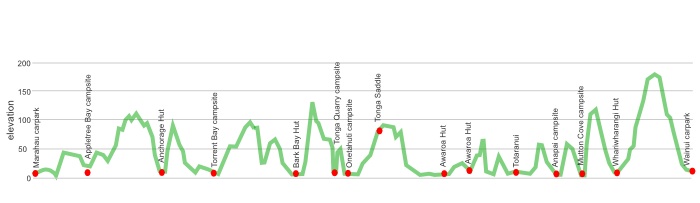
41 km Marahau carpark to Totaranui
13 km Totaranui to Wainui carpark
54 km total
time | Coastal Track, Abel Tasman NP
4 nights, ie, 5 days is common, but why not take an extra day off somewhere, just to soak up Paradise. That gives around four hours walk each day, there’s no need to rush through this.
when | Coastal Track, Abel Tasman NP
Anytime, the weather is relatively benign and there are no major rivers or mountain passes.
Missing peak season, ie, Christmas to Easter, will cut down on the hordes on the track and in the huts/campsites.
maps and GPS | Coastal Track, Abel Tasman NP
No big deal about maps on this track, you can get by with the free handouts at the iSite tourist information centres in Nelson, Motueka or Takaka. The track is extensively marked with great signage, you are unlikely to get lost, at least if you know where you want to go.
If you need another free alternative in the map department you can take a digital photo of the topographical maps that are on display at each roadend and at the huts, and look at your camera when you need clarification on your, or your next destination’s, whereabouts. They have a high enough level of detail.
If that’s not enough, and it probably is, there are a few options.
Download free digital versions from LINZ Mapchooser, then you can print off the areas you need yourself.
Or it’s possible to buy the real thing, ie, on old-fashioned paper, there’s a couple of detailed options there.
Newtopo, newtopo.co.nz, produces the most useful dead tree map of the Abel Tasman Coastal Track at a scale of 1:55,000, available for $11 from major DoC offices and some outdoor stores, Macpac keep them, or consult this list of retail outlets at newtopo.co.nz/where-to-buy.html.
There are also the Topo50 series maps that cover the country, for Abel Tasman you need two, BN25 Totaranui and BP25 Motueka, each costing around $7.90 and available at DOC offices, outdoor shops and bookshops where maps sold. There’s a nationwide list at LINZ Map Retailers.
Need a custom map for your GPS device, download a more compact .klm format file from topomap.co.nz for free, although if you download a few maps consider a small donation, there’s considerable work gone into getting that info onto the internet and we should support these useful resources.
route description | Coastal Track, Abel Tasman NP
Whether you go south to north, or north to south, is not a major issue. Starting in Marahau gets you through the more populated parts of the park early on and leaves the less frequented, and many think the more attractive, area north of Totaranui to the end.
Others will do the maths about when the best time to cross Awaroa Inlet might be and proceed accordingly. If the tide is rising you may have to wait 5 or 6 hours until the water has receded sufficiently.
huts and campsites | Coastal Track, Abel Tasman NP
Here are the four huts you may encounter on the Coastal Track in Abel Tasman National Park:
There’s more choice with the campsites, there’s a few more along the coast but they are only accessible by kayak:
Tonga Quarry campsite was severely storm damaged back in 2014 and has been permanently closed.
Tramping times | Coastal Track, Abel Tasman NP
Here’s the DoC-stated tramping times between huts, as shown on their website, usually actual walking times, ie, not taking into account any long breaks. DoC bases its estimation on times for an “average” tramper which means that it’s possible for fit trampers to slash times for the easy walking Coastal Track.
Unfortunately, this time information tends to emphasise a pointless aspect of tramping, The Destination, and, some trampers feel they need to test themselves, rush, to prove something to someone. Aren’t you there to experience your environment, notice things, go down to the river and spot a huge trout, and watch the bellbirds flitting around? There’s no actual requirement to occupy the full 10 hours a day racing through the landscape.
Marahau to Anchorage
Time: 4 hours
Distance: 12.4 km
Anchorage to Bark Bay
High tide track
Time: 4 hours
Distance: 12.1 km
Low tide crossing, Torrent Bay estuary
Time: 3 hours
Distance: 8.4 km
Bark Bay to Awaroa
Time: 4 hours
Distance: 11.4 km
Awaroa to Totaranui
Note that there are just 3.5 hours every 12 with the tide low enough to cross the Awaroa Estuary, you may have to wait. Check the tide times.
Time: 1 hours 55 minutes
Distance: 5.5 km (tidal)
Totaranui to Whariwharangi
Time: 3 hours
Distance: 7.5 km
Whariwharangi to Wainui
Time: 1.5 hours
Distance: 5.5 km
getting there | Coastal Track, Abel Tasman NP
There are scheduled trips from Nelson to Marahau car park via Richmond and Motueka, and also from Wainui to Nelson or Marahau. Unfortunately, the regularity of the various companies and routes has not yet settled back to what was once available pre-Covid in early 2020 when four companies did the routes. Hopefully we will return to plenty of choice soon.
Golden Bay Coachlines routes and timetables are still in flux due to Covid disruption.
Trek Express also offers various services. Nelson to Marahau is $35, and Nelson to Wainui is $65. They can also do special trips for a minimum group of four.
Getting around by hitching is also possible but, of course, entirely unreliable.
supplies | Coastal Track, Abel Tasman NP
Nelson, Richmond, and Motueka have the usual major supermarkets, Countdown, New World, Pak’nsave for getting the main supplies. Shellite or Fuelite and gas canisters for your stove can also be obtained at outdoor and hardware stores, if you haven’t been allowed to fly with it.
Takaka has a big FreshChoice, owned by Woolworths, with just about anything you could need in terms of food.
Elsewhere? Not much in the food/fuel range, ie, get everything you need before setting out.
warnings | Coastal Track, Abel Tasman NP
Check the tides, crossing Awaroa Inlet can’t be done on either side of high tide, ie, the water might be 2m+ deep.
The estuary can only be safely crossed within 1 hour 30 minutes before and 2 hours after low tide. DOC has a webpage with low tide times that are corrected for daylight saving time.
The other issue is the crowds, particularly in peak season: Christmas to Easter.
If you had any antisocial proclivities there are plenty of alternative tracks where you don’t have to deal with the hordes. On the Marahau to Onetahuti stretch you may well find you are meeting all the daytrippers who use the tourist boats, referred to as water taxis, to zip up the coast in the morning and then walk out, sometimes in their hundreds, wandering single file, sometimes smiling but towards the end of the day, often not.
other websites | Coastal Track, Abel Tasman NP
The DOC national park overview.
a big image slideshow | Coastal Track, Abel Tasman NP
Here’s a 42 image slideshow from the Coastal Track giving an indication of the general track conditions and sights along the way, if you need any further convincing.
Click on the thumbnail image below to get the slideshow started, then you can click on the left or right sides of the bigger images to go forward or back.

Images of the Coastal Track huts and campsites can be found in the, umm, Abel Tasman huts and campsites section.
An additional 6 images can be found on the blog pages, one image a day.