If Stewart Island’s North West Circuit is like Abel Tasman on steroids, the three day Rakiura Track, much through Rakiura National Park, is a minified version: a coastal walk with views to rocky bays; big rimu/rata forest; a golden sands beach to wander down; some historic artifacts from logging days, ie, big steam engines in unlikely places; an abandoned 1870s settlement at Port William; a chance to see, at least to hear, a kiwi in the wild; splendid views of Patterson Inlet/Whaka a Te Wera; more forest, regenerating from logging 100 years ago; plenty indeed.
And all from a great track, guaranteed 99% mud free.
Like all NZ Great Walks, this is probably the least traveled, the track is fully benched, ie, okay surface, mostly, maybe 70% imported gravel due to the otherwise soft, boggy in places, landscape a smooth gradient, if occasionally steep, clear markings, with few, maybe 2% timber steps, only where needed on the steeper inclines, that beats slipping and scrabbling over tree roots for the novice, all creeks bridged, the major hill just 200 m. The track from the suspension bridge over the Murray River to North Arm has been recut in 2012, now avoiding the tracts of rickety timber steps, and instead wandering between the trees and crown fern along low ridges, a real pleasure to walk.
No transportation required, you can walk from the ferry around to the end of the island’s longest road, a full 5 km, the start of the official track at Lee Bay, about an hour. You are in a different world, the land that time forgot.
So, a great track, no super big climbs, the possibility of spotting a kiwi or two, good huts, all compacted into three not so hard days.
Nice. Real nice.
where | Rakiura Track – Rakiura National Park, Stewart Island
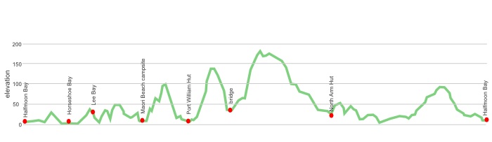
most people walk an anti-clockwise circuit from civilisation in Oban around the coast to Port William then a few short hill climbs on the way to North Arm and back to Oban. It’s all reasonably easy but the scenery is more varied on day one this way.
click to view larger, more interactive topographic map from, err, topomap.co.nz
distance | Rakiura Track – Rakiura National Park, Stewart Island
Rakiura Track 35 km – from/to Oban
time | Rakiura Track – Rakiura National Park, Stewart Island
3 days
when | Rakiura Track – Rakiura National Park, Stewart Island
Anytime?
Yes, the walk around the coast is at low level, obviously, the sea moderates the temperatures to a large degree so, believe it or not, it doesn’t really matter that much when you go despite being near 47º S. The rainfall is relatively consistent throughout the year, with perhaps surprisingly, July, August and September being the less wet months. But despite it raining on average every second day the total yearly rainfall in Oban, 930 mm, is less than that of Auckland or Wellington, so it rains often, but not for too long.
There’s a peak season, 1 October—30 April, and an off peak season, 1 May—30 September.
maps and GPS | Rakiura Track – Rakiura National Park, Stewart Island
You can get away with the $1 map from DOC. There are more detailed maps on the walls of the huts.
Need a custom map for your GPS device, download a more compact .klm format file from topomap.co.nz for free, although if you download a few maps consider a small donation, there’s considerable work gone into getting that info onto the internet and we should support these useful resources.
You could download free digital versions from LINZ Mapchooser and print out the bits you need. Or buy the real thing, ie, on old fashioned paper, at DOC offices, outdoor shops and bookshops where maps sold. There’s a nationwide list at LINZ Map Retailers.
If you feel you want something more detailed Newtopo, newtopo.co.nz, produces a great weatherproof map of the Rakiura Track at a scale of 1:45,000 which is available for $9 from major DoC offices and some outdoor stores, Macpac keep them, or consult this comprehensive list of retail outlets.
route | Rakiura Track – Rakiura National Park, Stewart Island
Anti-clockwise is the way to go, ie, from civilisation in Oban around the coast to Port William then a few short hill climbs on the way to North Arm and back to Oban. It’s all reasonably easy but the scenery is more varied on day one this way.
huts and camping | Rakiura Track – Rakiura National Park, Stewart Island
There’s two huts you will encounter on the Rakiura Track.
If you are keen to carry a tent there are three official campsites that have a longdrop toilet, a water tank and a shelter.
The Sawdust Bay campsite is no longer in use, the shelter and water tank have been removed.
Tramping times | Rakiura Track – Rakiura National Park, Stewart Island
Here’s the DoC stated tramping times between huts, as shown on their website, usually actual walking times, ie, not taking into account any long breaks. DoC bases its estimation on times for an “average” tramper which means that it’s possible to slash times for more popular sections. With more remote sections the stated time is close to the actual time required.
Unfortunately this time information tends to emphasise a pointless aspect of tramping, The Destination, and, some trampers feel they need to test themselves, rush, to prove something to someone. Aren’t you there to experience your environment, notice things, go down to the water, watch the bellbirds flitting around? There’s no actual requirement to occupy the full ten hours a day racing through the landscape.
Lee Bay to Port William Hut
Time: 3-4 hours
Distance: 8 km
Port William Hut to North Arm Hut
Time: 6 hours
Distance: 13 km
North Arm Hut to Fern Gully car park
Time: 4 - 4.5 hours
Distance: 11 km
Fern Gully car park to Halfmoon Bay
Time: 30 minutes
Distance: 2 km
getting there | Rakiura Track – Rakiura National Park, Stewart Island
Here’s a suggestion: take the ferry across to build up the suspense and then fly back when you can identify where you have been from the air. And you then won’t have to worry about the 15 kg baggage limit.
Flying: Three flights a day, at slightly varying times depending on the season, 365 days a year, from Invercargill airport to the strip on Stewart Island. The flight takes 20 minutes and can give a good overview of the island. There’s a minibus to take passengers to/from the Oban Post Office which is included in the fare. Fares: adult return $220, one way $130, with a variety of others depending on passenger’s age. Baggage limit: 15 kg, now that’s a problem when you are heading to the island because you really need to travel with all your kilos of food. Phone Stewart Island Flights on 03 218 9129.
Ferry: The express catamaran ferry is now owned by Real Journeys which has connecting buses to Invercargill, Queenstown and Te Anau. The trip takes about one hour from Bluff to Oban. There’s daily ferries, with more than one on many days but it’s a mighty complicated schedule and fare structure, Adult: $85 (one-way) $148 (return, Child: $43 (one-way) $74 (return). There’s also a connecting bus from Invercargill with each ferry for an additional $26 each way.
supplies | Rakiura Track – Rakiura National Park, Stewart Island
Invercargill, population 53,000, has the usual major supermarkets, Countdown, New World, Pak’nsave for getting the main supplies. Shellite or Fuelite for your stove can be obtained at outdoor and hardware stores if you haven’t been allowed to fly with it.
The small store, Ship to Shore Four Square supermarket, at Oban, population around 400, has a reasonable, if expensive, supply of food and basic camping needs, matches, candles, Fuelite and gas bottles not guaranteed, etc, and operates normal business hours, seven days a week.
warnings | Rakiura Track – Rakiura National Park, Stewart Island
There is no ATM/money machine in Bluff, or on Stewart Island/Rakiura, remember you are venturing to the edge of the Earth. Businesses will take card payments.
Heavy rain and strong winds can occur at any time of the year,
other websites | Rakiura Track – Rakiura National Park, Stewart Island
There’s a few websites about tramping around Stewart Island/Rakiura.
DOC has a pdf brochure with useful information
The DOC Rakiura Track site has fairly extensive information, including brief track notes from hut to hut.
a big image slideshow | Rakiura Track | Rakiura National Park
Here’s a 36 image slideshow from the Rakiura Track giving an indication of the general track conditions and sights along the way, if you need any further convincing.
Click on the thumbnail image below to get the slideshow started, then you can click on the left or right sides of the bigger images to go forward or back.
