Old gold mining relics.
An amazing limestone bluff gorge. Tree fern forests. Dramatic Tasman Sea views from 1000 m up.
A well-designed mountain bike track that is also easy enough walking for trampers.
Two new, and one renovated hut that all offer 5-star accommodation.
Yeah, there’s plenty to like.
where | Paparoa Track, Paparoa National Park
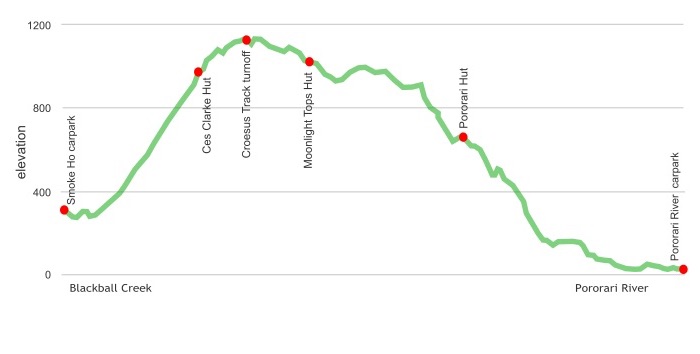
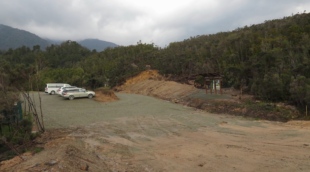
From Smoke-ho car park, 8 km up a mostly gravel road from Blackball, to Punakaiki on the West Coast. You climb up to a ridge, follow it, then slowly drop down to the coast.
click to view larger, more interactive topographic map from, err, topomap.co.nz
distance | Paparoa Track, Paparoa National Park
55 km from the Smoke-ho car park to the Punakaiki car park
time | Paparoa Track, Paparoa National Park
3 days/2 nights — tramping
2 days/1 night — mountain biking
when | Paparoa Track, Paparoa National Park
Best when there are longer and warmer days, ie, the summer months, November to May, but can be done at any time of the year.
maps and GPS | Paparoa Track, Paparoa National Park
Due to the excellent track, and track markers there is no great need to have a detailed map. A reasonable map can be downloaded from DOC: Paparoa Track Guide
The track is not yet shown on LINZ Topo50 maps.
route description | Paparoa Track, Paparoa National Park
Best to start at the Blackball end. That gets much of the sustained climbing over on the first day. The next days are mainly downhill. That is the direction the majority of walkers and mountain bikers are travelling.

huts and campsites | Paparoa Track, Paparoa National Park
There are 3 Great Walk huts along the route. You are not permitted to camp anywhere within 500 m of the track:
There’s also another historic, very basic, hut adjacent to Ces Clarke Hut.
Tramping times | Paparoa Track, Paparoa National Park
DOC has info on suggested walking allowances. Note here are actual walking times, for average trampers and don’t take into account much in the way of breaks.
Smoke-ho car park to Ces Clarke Hut
Time: 4 to 5 hours
Distance: 10.3 km
Ces Clarke Hut to Midnight Tops Hut
Time: 3 hours
Distance: 9.7 km
Midnight Tops Hut to Pororari Hut
Time: 5 to 7 hours
Distance: 9.1 km
Pororari Hut to Punakaiki car park
Time: 4 to 5 hours
Distance: 16 km
getting there | Paparoa Track, Paparoa National Park
Recommended to drop your car at the Punakaiki end and get a shuttle to take you to the start of the track that is 73 km away by road. The last 8 km from Blackball to the Smoke-ho car park is on a steep and at times narrow gravel road that may be better to not drive in a two-wheel-drive car. You would need two cars otherwise to get back to the relatively difficult to access Smoke-ho car park.
An Intercity bus travels past Punakaiki each day, leaving from Nelson at 7 15 am, Westport 10 45 am and arriving at 11 50 am. Another leaves from Greymouth at 1 30 pm and arrives at Punakaikiki at 2 15 pm.
The DOC car park at Punakaiki is near the mouth of the Pororari River, a few kilometres to the north of the DOC office.
73 km from/to Punakaiki by road.
supplies | Paparoa Track, Paparoa National Park
Nelson, Richmond, Greymouth, and Westport have the usual major supermarkets, either Countdown, New World, Pak’nsave, for getting the main supplies. Gas canisters, Shellite or Fuelite for your stove can be obtained at outdoor and hardware stores if you haven’t been allowed to fly with it.
Reefton has two small Four Square supermarkets that have most of the basics, open 7 days from 8 30 am weekdays, 9 am weekends.
warnings | Paparoa Track, Paparoa National Park
Great Walks don’t have too many concerns. DOC tends to iron these out to make the track and huts as safe and straightforward as possible. The huts and tracks are high-quality, although the track will take a while to truly bed in.
This is a Great Walk and you, therefore, need to book your hut mattress before you go. Popularity, and the small size of the huts will make it hard to get one of those bookings, so if you want to go, plan months ahead.
The track is used by both trampers and mountain bike riders. The bikers only need one night out, and tend to travel as a peloton so Moonlight Tops Hut, in particular, will tend to fill up very quickly. Tramping from Ces Clarke to Pororari Hut in one day is about 30 km, and would be a huge day for most.
So, once again. Trampers! Book early!
The huts have a mattress, and a gas cooktop, but you need to bring everything else. Include a sleeping bag, wet weather gear, and food in your luggage.
Half the track, including two of the huts, are all over 900 m, and it can be cold up there. And/or wet. It’s the West Coast so be prepared for rain. You are above the tree line, and very exposed to the weather.
Note. It can be perfect as well, so bring sunscreen.
All rivers and creeks are bridged, so you don’t need to worry about that.
Bike riders. The track is brand-new and hasn’t yet been smoothed out. Some of the rock is pretty shard-like. Looks like there will be damage to thin tyres. It’s a chunky track. And there are some reasonably substantial drop-offs.
It is mostly gentle Great Walk that has been super well thought through.
other websites | Paparoa Track, Paparoa National Park
DOC has the guide: Paparoa Track Guide.
a big image slideshow | Paparoa Track, Paparoa National Park
Here’s a 48 image slideshow from the Paparoa Track giving an indication of the general track conditions and sights along the way, if you need any further convincing. The section from Moonlight Tops Hut to Pororari Hut is missing as this was not opened due to a major slip.
Click on the thumbnail image below to get the slideshow started, then you can click on the left or right sides of the bigger images to go forward or back.
Images of the Paparoa huts can be found in the West Coast huts.
