Three passes to climb, two long treeless, trackless valleys, lots of views unobstructed by trees.
For those with a four-wheel drive, this is a good taster of what tramping in Marlborough has to offer. Plenty of variation in landscape.
You need a four-wheel drive to deal with the 38 km from State Highway SH 63 in the Wairau valley to Bottom Gordon Hut. Even with a lightweight four-wheel drive, you should be able to get to Bobs Creek, near the Leatham River crossing immediately before Barbers Hut.
The huts are great and unlikely to be at capacity. This area doesn’t get many visitors.
On the northern side, where the route is forested, the track is well enough marked. Well, for those with a keen eye. Once over Severn or Saxton Saddles, there are no markers at all. You make your own route, hence the “route” aspect in the name. That’s no big deal, as long as you are carrying the LINZ maps, it’s usually clear where to go.
If you have a desire for an excursion into typical Marlborough territory, this trip might satisfy your curiosity, as it takes in forests, alpine passes, and long grassy valleys.
where | Leatham/Molesworth route, Marlborough
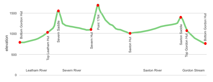
A loop track starts from Bottom Gordon Hut.
click to view larger, more interactive topographic map from, err, topomap.co.nz
distance | Leatham/Molesworth route, Marlborough
56 km
time | Leatham/Molesworth route, Marlborough
4—5 days
when | Leatham/Molesworth route, Marlborough
Anytime the weather is good but probably best when there are longer days, ie, the summer months, November to April. The Saxton River, Boundary Stream, and Gordon Stream need to be crossed. The Severn River does not.
Due to the high alpine climbs, a winter excursion would require an ice axe, crampons, and avalanche awareness.
maps and GPS | Leatham/Molesworth route, Marlborough
It’s essential to have a paper map in case GPS batteries die.
Land Information New Zealand, LINZ, Topo50 maps, both digital and paper: BS25 Severn and BS26 Mount Muller.
Download free digital versions from LINZ Mapchooser on Map 18 and Map 19, or buy the real thing, ie, on old fashioned paper, at DOC offices, outdoor shops and bookshops where maps sold. There’s a nationwide list at LINZ Map Retailers.
Need a custom map for your GPS device, download a more compact .klm format file from topomap.co.nz for free, although if you download a few maps consider a small donation, there’s considerable work gone into getting that info onto the internet and we should support these useful resources.
route description | Leatham/Molesworth route, Marlborough
From the end of the four-wheel drive track at Bottom Gordon Hut the track climbs increasingly steeply to Severn Saddle, 1585 m, with a big scree slide when over on the south side, down the Severn River valley, up over Point 1764 to the Saxton River, over Saxton Saddle, 1420 m, to Gordon Stream and back to the starting point.
If the Leatham River is up, or your transportation is not a real four-wheel drive, you may need to park your vehicle before the Leatham River crossing at Bobs Creek.
huts and campsites | Leatham/Molesworth route, Marlborough
There are some great newly renovated, or built, DOC huts along the way.
Team Hut Not for public use.
tramping times | Leatham/Molesworth route, Marlborough
Here’s the DOC stated tramping times between huts, as shown on their website, usually actual walking times, ie, not taking into account any long breaks. DOC bases its estimation on times for an “average” tramper which means that it’s possible to walk faster. On this track, there is considerable variation between the stated DOC times and what it would actually take, usually less. Some are way out, others close.
Unfortunately, this time information tends to emphasise a pointless aspect of tramping, The Destination, and, some trampers feel they need to test themselves, rush, to prove something to someone. Aren’t you there to experience your environment, notice things, experience the views, and watch the bellbirds flitting around? There’s no actual requirement to minimise the time racing through this memorable landscape.
Bottom Gordon Hut to Top Leatham Hut
Time: 4 hours
Distance: 7.4 km
Top Leatham Hut to Severn Hut
Time: 6 – 7 hours
Distance: 13.6 km
Severn Hut to Saxton Hut
Time: 8 – 9 hours
Distance: 11 km
Saxton Hut to Top Gordon Hut
Time: 7 – 9 hours
Distance: 18.5 km
Top Gordon Hut to Bottom Gordon Hut
Time: 3 hours
Distance: 5.5 km
getting there | Leatham/Molesworth route, Marlborough
This is the hard bit. There is a four-wheel drive track right to the door of Bottom Gordon Hut, but it is 38 km to the State Highway, SH63, in the Wairau Valley. There is a crossing of the fairly big Leatham River involved so don’t try this if there is the possibility of flooding. Some may need to leave their car at Bobs Creek, just short of Barbers Hut, further down the Leatham River.
You can always access the route from Molesworth Road, from where it is a few hours wandering up Saxton Valley to Saxton Hut. Some use that approach if they are coming from the Christchurch direction.
supplies | Leatham/Molesworth route, Marlborough
Blenheim, a population of around 30,000, has the usual major supermarkets, Countdown, New World, Pak’nSave, for getting the main supplies. All are open 7 days, 7 am to 10 pm.
Gas canisters, Shellite or Fuelite for your stove can be obtained at outdoor and hardware stores if you haven’t been allowed to fly with it.
St Arnaud has the world’s most expensive grocery store for a limited range of essentials.
warnings | Leatham/Molesworth route, Marlborough
Being only partially marked by DOC, that’s relatively well marked in the Leatham and Gordon valleys, and elsewhere essentially trackless, you make your own way, it is useful to have a copy of the LINZ maps.Some unbridged river crossings are required for the upper Leatham River, and more concerning, the bigger Saxton River.
Severn Saddle and Point 1764 are steep climbs, very steep at times, and the route requires the confidence to cross steep scree slopes. Charging down long scree slides as well, but that can be fun, kind of like slow-motion skiing.
In summer, from 1 January to 30 April, there is a requirement to obtain a DOC “Recreational Permit” to travel up the Saxton River. Contact the Renwick DOC office on 03 572 9100, or email renwick @ doc.govt.nz. Travel in the downstream direction at that time is not permitted, to avoid stampeding any cattle away from the top pasture. Who would police this is unclear. The rest of the year you can travel as you wish.
That means in summer you need to go in the Severn Saddle, Point 1764, Saxton Saddle direction, but that way makes sense in any case. Going down the large scree slope on the south side of Severn Saddle, the east side of Point 1764, and dropping into Gordon Stream would be considerably easier than the alternative. Who enjoys climbing up steep stretches of scree?
It seems the forested Gordon/Latham area is a common hunting area, so take care during “The Roar”, March/April, to wear bright clothes and avoid dawn/dusk travel. That’s when hunters come out in higher numbers. This shouldn’t be a concern, hunters usually identify their target, but better to be aware that it might be an issue.
It’s an alpine environment at times. You climb to 1585 m on Severn Saddle, and the top of Point 1764, and those locations are potentially exposed to strong winds, which in combination with wet conditions can cause major wind chill issue.
Severn Hut does not have any means of heating. There is no forest, and hence firewood, around Saxton Hut. These huts may be cool in winter although they are well insulated with double-glazed windows.
In summer the sun can be severe, even on a cloudy day. Wear sunscreen.
other websites | Leatham/Molesworth route, Marlborough
DOC has a webpage about the Leatham/Molesworth route.
DOC also has a standalone pdf factsheet about the Leatham/Molesworth route that you can print off and take with you.
a big image slideshow | Leatham/Molesworth route, Marlborough
Here’s a 35-image slideshow from the Leatham/Molesworth route giving an indication of the general track conditions and sights along the way, if you need any further convincing.
Click on the thumbnail image below to get the slideshow started, then you can click on the left or right sides of the bigger images to go forward or back.

Images of the Leatham/Molesworth route huts can be found in the Marlborough huts and campsites section.