This new loop has three energetic days from the easy-to-access and new Belltown Manunui Hut.
It takes in the pristine and beautiful Kākāpo River Valley, the head of the Taipo River, Little Wanganui Saddle, and the route back down the Little Wanganui River on the neglected Wangapeka Track.
This is all spectacular country and teams with birdlife. A great opportunity to encounter the nationally vulnerable whio/blue duck that most people only see on the New Zealand $10 note. Of course, there are numerous robins, tomtits, fantails of both varieties, wekas, and an occasional flight of kākā.
No kākāpo, however.
Kākāpo Hut was generally renovated in 2013 and had a new roof fixed in 2022. For a 65-year-old hut, it’s in surprisingly good condition. Few have visited in recent years due to a lack of a marked track, previously requiring an expedition of bush bashing and navigation. Hunting is poor, so few spent the night besides DOC goat contractors and the stoat/rat trapline checkers.
However, in 2020 Louisa Hines and Hayden Miller did some work on the section from the Little Wanganui Valley to Lawrence Saddle, and later Andrew Barker and occasional friends did most of the work in re-cutting and marking the remaining route from the old Belltown Manunui Hut site at Drain Creek over to Kākāpo Hut, and the section climbing from the Kākāpo River up to Kākāpo Saddle and down to the Wangapeka Track.
A two-hour section along the upper Kākāpo River is still a bush bash, although the almost pure kamahi isn’t the worst to forge through. Experience in off-track full-body physicality is an advantage. It’s the West Coast, after all.
The track down from Little Wanganui Saddle to complete the loop back to Belltown Manunui Hut is strangely unmaintained by DOC and is hard work going through the overgrown ferns.
It’s an excellent, at times demanding loop, with no major unbridged river/stream crossings and plenty to offer the adventurous.
where | Kākāpo River loop, Kahurangi National Park
Heading over to Kākāpo Hut first seems sensible as the climbing to Little Wanganui Saddle is done over a few days. Trail finding is possibly easier that way.
click to view larger, more interactive topographic map from, err, topomap.co.nz
distance | Kākāpo River loop, Kahurangi National Park
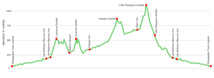
Wangapeka carpark to Belltown Manunui Hut, 10 km each way.
From Belltown Manunui Hut to Kākāpo Hut, over Kākāpo Saddle and Little Wanganui Saddle and back to Belltown Manunui Hut, 32 km circuit.
So, 52 km all up.
when | Kākāpo River loop, Kahurangi National Park
November to May is best when the days are longer. Snow is seldom an issue; even rain is not much of a problem due to the swingbridges.
maps and GPS | Kākāpo River loop, Kahurangi National Park
The area but not the new track is on Land Information New Zealand, LINZ, Topo50 series paper maps: BQ22 – Karamea and BQ23 – Wangapeka Saddle. These maps can be bought online and some tramping supply shops: Hunting and Fishing is your best bet.
Better is to download a digital version at the LINZ website. Then you can print your own parts of the map that you require. Or upload the maps to your phone.
Most people these days pay for one of the excellent phone apps. NZ Topo50 South Island, $NZ 6.99, does the simple stuff reasonably well, like allowing the upload of particular track files and recording. It works without an Internet connection and has one super important feature: it shows exactly where you are.
route description | Kākāpo River loop, Kahurangi National Park
The tramp into the first hut from the Wangapeka Track carpark is mostly flat and well-marked. Just the one spot where you climb and may use some new stainless steel chains.
The old Belltown Manunui Hut, only built in 2001, was moved about 1 km downstream in 2022 as it had been built on an old earthquake slip that started moving.
The track to Kākāpo Hut starts immediately behind the old Belltown Manunui Hut site. It’s fairly obviously marked, and that’s how it continues to the hut.
It starts with a gradual climb up about 250 m on a very well-marked track in the open forest to Lawrence Saddle. The drop down to Bellbird Stream and route around to “the swamp” is straightforward. The swamp is just squidgy underfoot at this stage, but it may get cut up with more foot traffic. The climb up to the unnamed saddle is steeper, but it is a short sharp 250 m climb that doesn’t go on.
So far, so good.
The next section is more demanding. From the unnamed saddle, it’s more of an effort with a 60 m descent on the steep chunky scree, which you immediately climb back up.
It’s a long sidle from the ridge around a more chunky and steeply sloping landscape to the valley floor to a well-marked trapline leading to the hut through some pristine beech forest.
The trapline extends about 3 km upstream from Kākāpo Hut, with sporadic pink DOC markers, and Permolat markers have not been added. It finishes at the top of a widening of the valley. A marker on the other side of the river just marks the end of the trapline on the other side.
From there, the route is unmarked and uncut, and so it’s everyone for themselves. At times it’s okay to forge up the river, but the kamahi forest offers easier access for much of the way. Except when it doesn’t. You just need to keep moving, however best you manage it.
You need to keep an eye out for the start of the track up Kākāpo Saddle, but it is where it is shown on the map on the Remote Huts webpage. Andrew Barker has done a magnificent job in marking the route and the long way down to the Wangapeka Track at Herbert Creek. In 2023 the Wangapeka Track seems abandoned by DOC, but the route is fairly obvious, even if at times there’s plenty of vegetative overgrowth.
The views from Little Wanganui Saddle are great, if the weather is good, but the track down takes longer than you might think as the ferns hide whatever you are clambering over. Some muttering may be heard.
From the old hut site it’s only 20 minutes or so back to the new Belltown Manunui Hut.
The walk down to the roadend from the new Belltown Manunui Hut is mostly straightforward and takes about four hours.
huts | Kākāpo River loop, Kahurangi National Park
Belltown Manunui Hut and Taipo Huts are on the Wangapeka Track, but this is not hugely popular these days. Few visit the four-bunk Kākāpo Hut either, although this may change.
Belltown Manunui Hut has been relocated about 1 km downstream and now is about 300 m upstream from the Lawrence Stream swingbridge.
Note that there are few campsites in the Kākāpo River valley due to the lumpy and damp terrain.
tramping times | Kākāpo River loop, Kahurangi National Park
Here’s the DOC and Remote Huts tramping times between huts, usually actual walking times, ie, not taking into account any long breaks. The Wangapeka may take longer in some places due to a lack of maintenance on the track.
Wangapeka Track West Coast road end to new Belltown Manunui Hut
Time: 4 hours
new Belltown Manunui Hut to old Belltown Manunui Hut site
Time: 20 minutes
old Belltown Manunui Hut site to Kākāpo Hut
Time: 6 — 8 hours
Kākāpo Hut to Taipo Hut
Time: 7 — 9 hours
Taipo Hut to Little Wanganui Shelter
Time: 3 hours
Little Wanganui Shelter to new Belltown Manunui Hut
Time: 4 hours
new Belltown Manunui Hut to Wangapeka Track West Coast road end
Time: 4 hours
getting there | Kakapo River loop, Kahurangi National Park
No reliable public transport is available currently.
supplies | Kākāpo River loop, Kahurangi National Park
Westport has two supermarkets, New World and Freshchoice, for your main supplies. Gas canisters, Shellite or Fuelite for your stove can be obtained at outdoor and hardware stores if you haven’t been allowed to fly with it.
Karamea has a small Four Square supermarket with most of the basics, open 7 days from 8 30 am weekdays to 9 am weekends.
warnings | Kākāpo River loop, Kahurangi National Park
Not for inexperienced trampers, despite the track into Kākāpo Hut being very well marked.
The route as far as the unnamed saddle is fairly cruisy through the generally open forest. From there, it’s rougher underfoot with steep scree, both down and up. Not beyond many, but it’s an energy-expending day that will take some closer to eight hours than six hours.
Once on the trapline track down on the valley floor, it gets easier as you approach Kākāpo Hut.
Heading upstream from the hut is a different story, with the trapline track less frequently marked, and after 3 km, it ends.
No track for two hours or more as you continue up the valley.
It is possible to head straight up the river for a while, but the valley gets steeper, the rocks chunkier, and the river isn’t always easy to cross. The bottom of the valley is usually in the shade, so the rocks are moss-covered and slippery. Many would find it easier to crash cross-country through the kamahi forest. This varies between stretches of pure joy and your typical West Coast full-body wrestle.
But like all things, both good and bad, it comes to an end.
Then there is a short sharp 250 m climb to Kākāpo Saddle on a well-marked route over to the Wangapeka Track.
The three biggest water courses, Lawrence Stream, Pannikin Creek, and Little Wanganui River, all have swing bridges, but a few of the small tributaries may be difficult to cross during heavy rain. The terrain is steep, so they go down quickly.
Little Wanganui Saddle has short periods of snow in mid-winter, ie, July/August, but it’s not likely to last for long.
The major danger is probably coming off the track, most likely at a windfall, and this could get you into trouble if you don’t quickly retrace your steps. Or, running out of daylight, as there are few places to camp. Too many clumps of ferns. Lumpy terrain. Sloping, damp ground conditions.
Note that the Wangapeka Track has had limited maintenance, and the Little Wanganui River Valley isn’t exactly in Great Walk condition. It’s currently overgrown with ferns and has ups and downs that take time to negotiate. When it’s wet, it’s like moving through an automatic car wash.
Other than that, you’ll have a rewarding trip.
You are really on your own out there, so remember to pack an ELB, Emergency Locator Beacon.
other websites | Kākāpo River loop, Kahurangi National Park
Remotehuts.co.nz has extensive information about Kākāpo Hut and how to get there. Excellent website from Andrew Buglass.
a big image slideshow | Kākāpo River loop, Kahurangi National Park
Here’s a 48-image slideshow from the Wangapeka Carpark around the loop, giving an indication of the general track conditions and sights along the way if you need any further convincing.
Click on the thumbnail image below to get the slideshow started, then you can click on the left or right sides of the bigger images to go forward or back.

Images of the Kahurangi huts can be found in Other Kahurangi huts.