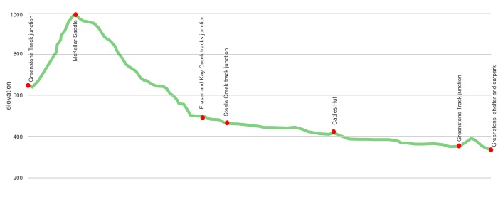
The Caples is a narrower, more intimate valley than the Greenstone, generally more appealing, more spectacular. You don’t miss out on the chasm factor, there’s one near the hut, more dramatic than the Greenstone if you require a comparison. The forest is lovely, it helps the track being on the south side of the river with the additional light allowing more undergrowth and the dramatic red beech trees. Then there’s a gradual climb to the McKellar Saddle, the valley gets much tighter up there, big cliffs are close so that provides the winter/spring avalanche concerns, and towards the top the bush line is reached.
The saddle is potentially exposed to the onslaught by wind and weather in general but there’s a huge view over the edge down to Lake McKellar and into the Greenstone and indeed over to Mt Christina in the Darran Range.
The Caples Track has been extensively modified in recent years —the Upper Caples Hut is now in the possession of the New Zealand Deerstalker’s Association and is not available to the public, a super-beaut hut has been built on the old Mid Caples Hut site, and, perhaps most significantly, a major realignment of the upper section of the track, think bulldozer and a continual drainage channel.
The surprise is how short the walk is now, it’s well possible to zip through, end to end, on one of those long summer days.
With the Routeburn Track becoming saturated with trampers for much of the Summer Season DOC’s idea seems to be to combine the Caples/Greenstone into a loop as an alternative, and it now works well in that regard.
Need to select the track to complete a loop with the Routeburn? Greenstone or Caples?
The answer: the Caples, obviously.
where | Caples Track, Greenstone Conservation Area
You can walk this track from either direction, ie, from the east starting at the Greenstone Shelter, at the end of the road from Kinloch at the head of Lake Wakatipu, 86 km from Queenstown, or from the west at The Divide, on the Milford Road, 85 km north of Te Anau.
click to view larger, more interactive topographic map from, err, topomap.co.nz
distance | Caples Track, Greenstone Conservation Area
40 km from the Greenstone carpark near Kinloch, to The Divide on the Milford Road
61 km as part of the Greenstone Caples Track loop from the Greenstone carpark
time | Caples Track, Greenstone Conservation Area
2 days, Greenstone carpark near Kinloch, to The Divide on the Milford Road, or,
4 days, Greenstone – Caples Track loop from the Greenstone carpark near Kinloch
when | Caples Track, Greenstone Conservation Area
November to late May. There’s significant avalanche danger in winter and early spring. Check with DOC about the avalanche danger, it is very real.
maps and GPS | Caples Track, Greenstone Conservation Area
On the extremely well marked and signposted track there’s little real requirement for anything more than the map in the free DOC brochure.
It is possible to buy a real map, ie, on old-fashioned paper. The Newtopo Routeburn-Greenstone-Caples Map at a scale of 1:40,000, $24, is available from major DoC offices and some outdoor stores, Macpac keep them, or consult their comprehensive list of retail outlets at newtopo.co.nz/where-to-buy.html.
Need a custom map for your GPS device, download a more compact .klm format file from topomap.co.nz for free, although if you download a few maps consider a small donation, there’s considerable work gone into getting that info onto the internet and we should support these useful resources.
route description | Caples Track, Greenstone Conservation Area
From the Queenstown side the track follows up the Greenstone River, which soon branches off and becomes the Caples River valley, but it widens somewhat as far as the Upper Caples Hut further up. The track then turns into a, more or less, bulldozed road, it will take a few years for the recent damage to the forest to ameliorate.
The section over the McKellar Saddle is the most scenic, the cliffs are all around, it is quite dramatic.
huts | Caples Track, Greenstone Conservation Area
Caples Track huts? There’s now only one and it is relatively new, ie, 2014. Note: the Mid Greenstone Hut and Upper Caples Hut are no longer available for use by trampers.
There are two huts on the nearby Greenstone Track:
There is also one official campsite available, although you can also camp around any of the huts.
Two shelters are at either end of the track.
Greenstone roadend shelter and carpark
The Divide shelter and carpark
There’s also a couple of basic huts in the vicinity:
Kay Creek Hut
tramping times | Caples Track, Greenstone Conservation Area
Here’s the DOC stated tramping times between huts, as shown on their website, usually actual walking times, ie, not taking into account any long breaks. DOC bases its estimation on times for an “average” tramper which means that it’s possible to walk faster.
Unfortunately this time information tends to emphasise a pointless aspect of tramping, The Destination, and, some trampers feel they need to test themselves, rush, to prove something to someone. Aren’t you there to experience your environment, notice things, experience the thundering waterfalls, watch the bellbirds flitting around? There’s no actual requirement to minimise the time racing through this memorable landscape.
Greenstone shelter and road end to Mid Caples Hut
Time: 2 – 3 hours
Distance: 9 km
then either, via McKellar Saddle and the Greenstone Track to McKellar Hut
Mid Caples Hut to McKellar Hut
Time: 6 – 7 hours
Distance: 22 km
or, via the Routeburn Track to The Divide
Mid Caples Hut to old Howden Hut site
Time: 6 – 7 hours
Distance: 21 km
Old Howden Hut site to The Divide shelter
Time: 1 hour – 1 hour 30 minutes
Distance: 3.4 km
Side trip – Key Summit
Time: 1 hour – 1 hour 30 minutes
getting there | Caples Track, Greenstone Conservation Area
This is what was happening pre-2020.
Track and Info provides a service to the Greenstone shelter and carpark, past Kinloch, leaving Queenstown at 8 am, Glenorchy 9 15 am, arriving 10 am. Departs Greenstone shelter at 12 noon for return to Queenstown. Cost: Queenstown, $60 adult, $47 child. Glenorchy, $37 adult, $27 child. They also service The Divide, $81 adult, $60 child, leaving Queenstown 6 55 am and 10 45 am, and The Divide at 10 10 am and 3 15 pm. Confused? Contact on 03 442 8215.
Tracknet have scheduled services to The Divide on seven days a week during the summer season, leaving from Queenstown, $78 adult, $58 child, at 6 55 am and 10 45 am, or Te Anau, $39 adult, $28 child, at 7 15 am, 9 45 am, 12 15 pm and 1 30 pm, and getting to The Divide 75 minutes later, plenty of time to get to McKellar Hut and see the features along the way, ie, Key Summit and Lake Howden.
Tracknet picks up from The Divide on the way back from Milford to Te Anau at 10 10 am, 1 30 pm, 3 15 pm and 5 45 pm, seven days a week. The 10 10 am and 3 15 pm continue on to Queenstown. Prices as above. They also go to Milford Sound, why not, as it’s close, $35 adult, $26 child, at 8 30 am, 11 00 am and 2 45 pm.
Trips and Tramps do a scheduled run from Te Anau to The Divide six days a week, all year around, except when the Milford Road is officially closed in winter, and will drop you off for $40. Book early to confirm place.
The system is different during the Winter Season, when services only proceed if there are bookings.
Hitching is possible from Te Anau to The Divide, straightforward, there’s plenty of people each day travelling to Milford Sound further down the road, whether they want anyone else in their car on their holiday is another thing. Not so straightforward from The Divide, there’s no shoulder on the busy road, 70 full tourist buses zip along here in the busy season. Probably best just to ask people directly in the big carpark. Yeah, put them on the spot.
There’s reasonable day tripper traffic up to the Greenstone carpark, but don’t be surprised if it takes a few rides to hitch hike to, or from, Queenstown.
supplies | Caples Track, Greenstone Conservation Area
Queenstown has two major supermarkets: Freshchoice, open 7am to midnight seven days; Wakatipu New World, open 8am to 9pm, also seven days.
There are many shops in Queenstown selling Shellite or Fuelite and gas canisters for your stove: Alpine Sports, Outside Sports, H & J’s Outdoor World, Kathmandu and Macpac. There is also a big Mitre 10 which might be the cheapest option.
Te Anau has one major supermarket, Freshchoice, open 7am to 9pm seven days. There is also a small 4 Square with similar, but marginally truncated opening hours.
Shellite or Fuelite and gas canisters for your stove can be obtained at Outdoor Sports, Fiordland Frontier Supplies, both open Monday – Friday 9.00 am–5.30 pm and Saturday 9 am-1 pm, or Mitre 10, Monday – Friday 8 am-5.30 pm, Saturday 9 am-4 pm, Sunday 11 am-3 pm, if you haven’t been allowed to fly with it. All these shops are in the main shopping area of Te Anau.
warnings | Caples Track, Greenstone Conservation Area
In winter to late spring check with DOC about the avalanche danger. This is a real danger when heading over McKellar Saddle.
other websites | Caples Track, Greenstone Conservation Area
DOC has a track guide on the tramp.