The theory: a walking track between Wanaka and Arrowtown, with three purpose built huts.
The reality: a gruelling track that seldom has a flat moment, strenuous climbs abound, and then, for many, it’s easier just wading down, or up, the Arrow River. Then there’s a choice of another 20+ river crossings between Macetown and Arrowtown on a 4WD track, or another 400m climb and descent over Big Hill.
So, it’s physically demanding, don’t bother bringing unneeded luggage.
The positive is that the Motatapu cuts through so remarkably smashed up landscape, the hills around Highland Creek are particularly shattered and monumental.
where | Motatapu Track
The northern end starts a few kilometres up the Motatapu Road, turnoff at Glendhu Bay near Wanaka. The Motatapu heads over the hills parallel to the Crown Range Road to the official conclusion at Macetown.
There’s still the question of getting to Arrowtown. Two options present: more Arrow River, you really get into it, or another trudge over Big Hill.
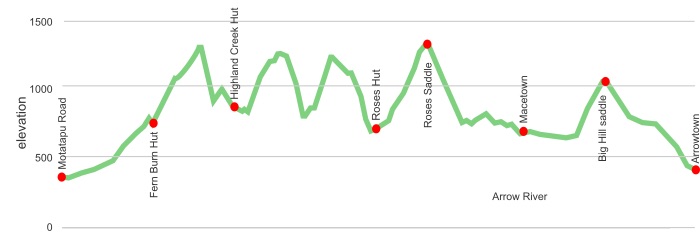
click to view larger, more interactive topographic map from, err, topomap.co.nz
distance | Motatapu Track
34 km one way Motatapu Road carpark to Macetown
15 km Macetown to Arrowtown
time | Motatapu Track
3 – 4 days, depending on your enthusiasm for walking
when | Motatapu Track
Avoid snow, ie, go in the summerish months, November to April.
Also avoid heavy rain, the Arrow River crossings can be impassable. There are no bridges.
maps and GPS | Motatapu Track
There’s little reason to have any map beyond the free map as part of the general information brochure.
There’s a detailed map on the wall at each of the huts that you can take a photo of if you need reassurance.
Download free digital versions from LINZ Mapchooser, or buy the real thing, ie, on old fashioned paper, at DOC offices, outdoor shops and bookshops where maps sold. There’s a nationwide list at LINZ Map Retailers.
The main map you need is Topo50 CB12 Cardrona with some of the trail falling into CB11 Arrowtown.
Need a custom map for your GPS device, download a more compact .klm format file from topomap.co.nz for free, although if you download a few maps consider a small donation, there’s considerable work gone into getting that info onto the internet and we should support these useful resources.
route description | Motatapu Track
Either direction is fine, except for the thought that beginning at the southern end, ie, Arrowtown, gets the major river crossings out of the way.
huts and camping | Motatapu Track
There are three DOC huts that each cost $5 per person a night. You can camp outside these huts for a big nutting’, ie, free.
There’s also an official DOC campsite at Macetown, with the best price: free.
tramping times | Motatapu Track
Here’s the DOC stated tramping times between huts, as shown on their website, usually actual walking times, ie, not taking into account any long breaks. DOC bases its estimation on times for an “average” tramper which means that it’s possible to walk faster.
Unfortunately this time information tends to emphasise a pointless aspect of tramping, The Destination, and, some trampers feel they need to test themselves, rush, to prove something to someone. Aren’t you there to experience your environment, notice things, experience the views, watch the bellbirds flitting around? There’s no actual requirement to minimise the time racing through this memorable landscape.
Arrowtown carpark to Macetown campsite via Big Hill
Time: 4 – 5 hours
Distance: 15 km
or
Arrowtown carpark to Macetown campsite via Arrow River
Time: 3 – 4 hours
Distance: 15 km
Macetown campsite to Roses Hut
Time: 5 – 6 hours
Distance: 10 km
Roses Hut to Highland Creek Hut
Time: 7 – 8 hours (that seems fairly conservative, 5—6 more likely)
Distance: 11 km
Highland Creek Hut to Fern Burn Hut
Time: 4 – 5 hours
Distance: 6 km
Fern Burn Hut to Motutapu Rd
Time: 3 – 4 hours
Distance: 7 km
getting there | Motatapu Track
Public transport is available to both Wanaka and Arrowtown.
It is possible to walk around Lake Wanaka on the Te Araroa Trail. There is a good commercial campsite at Glendhu Bay where you turn off on the Motatapu Road to the start of the trail.
supplies | Motatapu Track
Wanaka, population 10,000, has a New World supermarket in the main street.
Queenstown the usual major supermarket, New World, but it is located in Frankton just past the airport, 7km from downtown Queenstown. There’s a bus out there. The Freshchoice, a kilometre from the centre on the Arrowtown road, is big enough to stock most items you would need at a significantly more competitive price than the Alpine Store right in town.
Shellite or Fuelite for your stove can be obtained at outdoor and hardware stores if you haven’t been allowed to fly with it.
Arrowtown has a small grocery store that would rate as one of the world’s most expensive. Certainly cheaper to stock up in Wanaka or Queenstown.
warnings | Motatapu Track
Don’t be mistaken by the relatively short distance, it’s actually one of the more energetic of the named tracks around. There is about 3000 m climbing involved, that’s a fair grunt, in fact little of the track is flat.
The track from Motutapu Rd at the northern end is benched and bridged. After that, except for Fern Burn, none of the creeks or rivers are bridged.
There’s no “town” at Macetown. No shops, inhabited houses, town square, etc.
There are 21 crossings of the Arrow River required from Arrowtown to Macetown and while this is easily forded in dry conditions it is a dangerous crossing after heavy rain. The Arrow River must be forded at least once between Macetown and Roses Hut. There are many other smaller creeks which will be too dangerous to cross after heavy rain. On a happier note the rivers will, however, start to drop almost as soon as the rain stops falling, the catchments are short and steep.
Not a winter trip when snow is around. There’s a fair amount of sidling around on steep slopes and it can be extremely slippery/icy.
other websites | Motatapu Track
DOC has a website about the Motatapu track
There’s also a Motatapu Track brochure to download.
a big image slideshow | Motatapu Track
Here’s a 44 image slideshow from the Motatapu Track giving an indication of the general track conditions and sights along the way, if you need any further convincing.
Click on the thumbnail image below to get the slideshow started, then you can click on the left or right sides of the bigger images to go forward or back.
