The famous hot pools up at Welcome Flat encourage use of this historic route up the Copland Valley.
Why not? The track in is relatively easy, just a few hundred metres of rock hopping required, and most of the creeks are bridged including Shiels Creek that has the highest swingbridge many are likely to encounter.
Carrying a pack for seven hours to the hut gives a decent workout so an hour in the hot pools is totally appreciated.
Water runs into the pools at 57° C or thereabouts, and the hut warden attempts to maintain the temperature around the 39° C mark to avoid cooking weary bodies.
Note: the hut wardens are there most of the year, and will check your booking. They don’t allow you to stay on the living area floor if there are no spare mattresses.
The well-maintained track further up the valley continues on easy enough for the most part to Douglas Rock Hut, although it has a few moments of slippery rocks to negotiate. Most should be able to enjoy. Past that is really only for the super enthusiastic, but it is possible to climb to Copland Pass following the avalanche season. That section sure ain’t easy.
The track was initially created in the 1910s to 30s to give more direct access from Mount Cook Village to Fox Glacier over Copland Pass, 2150 m. The recession of the Hooker Glacier and unfreezing of some of the glacial moraine now makes the eastern side of the route ridiculously dangerous.
Anyway, join the throng in those very welcome hot pools. And prepare to be social on this track.
where | Copland Track, South Westland
From the Karangarua River carpark, 26 km south of Fox Glacier, to Douglas Rock Hut.
click to view larger, more interactive topographic map from, err, topomap.co.nz
distance | Copland Track, South Westland
20 km carpark to Welcome Flat Hut. Another 7 km each way to Douglas Rock Hut
time | Copland Track, South Westland
2 days to get in and out, although an extra night can be spent to visit Douglas Rock Hut
when | Copland Track, South Westland
Pretty much all year round as
In winter there may be snow and/or ice, in the valley.
maps and GPS | Copland Track, South Westland
The DOC brochure or a cell phone app is all you probably need to get as far as Douglas Rock Hut. After that best to have a paper map as well.
Land Information New Zealand, LINZ, Topo50 maps, both digital and paper: BX14 Gillespies Beach; BX15 Fox Glacier.
Download free digital versions from LINZ Mapchooser page 21, or buy the real thing, ie, on old fashioned paper, at DOC offices, outdoor shops and bookshops where maps sold. There’s a nationwide list at LINZ Map Retailers.
Need a custom map for your GPS device, download a more compact .klm format file from topomap.co.nz for free, although if you download a few maps consider a small donation, there’s considerable work gone into getting that info onto the internet and we should support these useful resources.
route description | Copland Track, South Westland
The Karangarua River carpark is on the north side of the Karangarua River bridge, and is well signposted on SH6. It’s 150 m off the highway behind a gate.
The track starts by crossing Rough Creek, just to rinse your feet, and then you can get into some muddy bits.
The track climbs on an increasingly steep gradient up the valley, crossing the creeks on steel or wire swing bridges. Much of the walking is in the forest, but there are sections of boulder hopping adjacent to the river.
One view is offered at the Karangarua River junction looking up the valley. Also The Punchbowl waterfall on Therma Creek.
huts and campsites | Copland Track, South Westland
There are a few different accommodation types, but remember that this is a fairly wet area of New Zealand and sometimes a roof is preferable.
Camping is permitted pretty much anywhere in the valley for free if you can find a spot. Near the Welcome Flat Hut you do need to camp in the official places.
tramping times | Copland Track, South Westland
Here’s the DOC stated tramping times between huts, as shown on their website, usually actual walking times, ie, not taking into account any long breaks. DOC bases its estimation on times for an “average” tramper, which means that it’s possible to walk somewhat faster.
Unfortunately this time information tends to emphasise a pointless aspect of tramping, The Destination, and, some trampers feel they need to test themselves, rush, to prove something to someone. Aren’t you there to experience your environment, notice things, experience the views, watch the bellbirds flitting around? There’s no actual requirement to minimise the time racing through this memorable landscape.
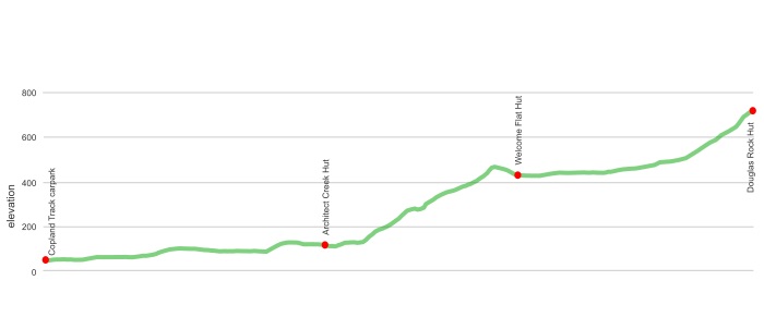
carpark to Architect Creek Hut
Time: 4 hours
Architect Creek Hut to Welcome Flat Hut
Time: 3 hours
Distance: 18 km from carpark
Welcome Flat Hut to Douglas Rock Hut
Time: 3 hours
Distance: 7 km according to DOC
getting there | Copland Track, South Westland
Public transport can work well if you stay at Fox Glacier, or Franz Joseph for that matter. The Intercity bus to Queenstown leaves at 8 00 am from Franz at the bus stop in the Main Road, and 8 45 am from Fox, outside the supermarket, and can drop you off 26 km down the road at the start of the 150 m walk to the carpark. The bus from Queenstown comes past at about 2 45 pm but you need to pre-book, probably won’t stop if youi just stand by the side of the road. Confirm time with Intercity.
The carpark usually has quite a few cars in it so it isn’t the worst place to leave it for a few days. People seem to stay in their vans overnight there as well, although that is not supposedly allowed.
Of course you can hitch from or to Fox, after all it’s only 26 km down the road.
supplies | Copland Track, South Westland
Both Fox and Franz Joseph have small supermarkets with fairly limited offerings. Franz is bigger.
Franz Joseph hours: 7 45 am to 7 30 pm
Fox hours: 8 am to 6 30 pm
Otherwise you should buy all your necessities in Hokitika at the big New World supermarket, open 7 days, 8 am — 8 pm, or wherever you are coming from.
warnings | Copland Track, South Westland
For those unaccustomed to New Zealand conditions Welcome Flat is further, more slippery, and generally more gnarly than might be expected. The track is great by general New Zealand tramping standards, but it’s not actually quite Great Walk standard.
This is one of the wettest regions in New Zealand, and hence be prepared for dampness. Your footwear is likely to get wet.
And the track is occasionally closed by DOC due to issues crossing flooded creeks.
Unabridged creeks can rise quickly and become ferocious, but then fall quickly due to the steepness of the terrain.
In Winter and into Spring there are a couple of avalanche paths to cross, but these are clearly marked on the track.
A hut warden at Welcome Flat Hut will ask to see your booking, and extract money if you have failed to pre-book. Don’t expect a bunk mattress if you have failed to do so as this is one of the most popular huts on the West Coast. The hut wardens don’t allow you to sleep on the living room floor. Instead you will be banished to your tent, or under the rock bivvy. So, it’s important to book prior to trudging the seven hours up the valley. Or you may need to go back to Architect Creek Hut, it ain’t so great, or on to Douglas Rock Hut. No hot pools at either location.
Oh, and this is a surprise to some who venture up there, they don’t have a chef to prepare your meals, or a bar, or bedding. You need to come prepared with your own food, stove, sleeping bag, etc. All you get is a roof, a mattress, and tables and benches.
No hot shower. But then again there are those hot pools.
other websites | Copland Track, South Westland
DOC has a downloadable pamphlet on the Copland Track, and Copland Track, and the Upper Copland Valley Track on the DOC website.
a big image slideshow | Copland Track, South Westland
Here’s a 35 image slideshow from the Copland Track giving an indication of the general track conditions and sights along the way, if you need any further convincing.
Click on the thumbnail image below to get the slideshow started, then you can click on the left or right sides of the bigger images to go forward or back.

Images of the Copland Track huts and campsite can be found in the West Coast huts and bivvies section.