A popular, scenic and relatively easy wander for those who enjoy camping at any time of the year.
Actually, the majority of walkers are those preferring to carry not much on their back, making use of the service to transfer their luggage via boat between boutique accommodation selections.
You also share the track with mountain bikes and mountain bikers doing their more adrenaline-charged thing.
The Queen Charlotte walkway is just one step beyond the Abel Tasman level of endeavour, ie, low on the scale of tramping effort. Don’t be surprised if you meet lipstick-wearing 70-year-olds, or, folks more interested in where cell phone coverage can be obtained than immersing themselves in nature. Unlike the Abel Tasman coastal track the Queen Charlotte route often winds along the tops of ridges with big views of Grove, Kenepuru Sound and the many coves of, err, the Bay of Many Coves.
Most will be unconcerned, or perhaps not notice that the landscape has been seriously modified by fire over the years. The beech forest will take centuries to regenerate.
The Queen Charlotte Track is, however, well suited to those urbanites who desire a taste of the New Zealand outdoors experience, including extensive dramatic vistas, but don’t want to venture far from nightly home comforts in an environment that is clearly high on safety and security. There are a significant number of accommodation/cafe establishments that offer the usual urban comforts, a few right at the top end of luxury.
where | Queen Charlotte Track, Marlborough Sounds
The northern end starts after an hour-long, and scenic water taxi ride to Cooks Cove on the Cook Strait end of Queen Charlotte Sound. The track winds its way south, mainly along ridges, to the road end at Anakiwa.
click to view larger, more interactive topographic map from, err, topomap.co.nz
distance | Queen Charlotte Track, Marlborough Sounds
71 km one way
time | Queen Charlotte Track, Marlborough Sounds
3 – 4 days, depending on your enthusiasm for walking
when | Queen Charlotte Track, Marlborough Sounds
Anytime the weather is good but probably best when there are longer days, ie, the summer months, November to April.
Summer during any school holiday period is particularly busy. There are more people using the track at the weekends.
maps and GPS | Queen Charlotte Track, Marlborough Sounds
You can get away with the free tear-off map from DOC, or you can print your own version. There are also reasonably detailed maps on the signage at major track points, ie, ends, major road junctions. Take a photo of one of them for your reference. You are unlikely to get lost.
If you feel you want something more detailed Newtopo.co.nz produces a great weatherproof map of the Queen Charlotte Track at a scale of 1:40,000 which is available for $24 from major DoC offices and some outdoor stores. Macpac also keeps them, or consult the website for an up to date comprehensive list of retail outlets.
Land Information New Zealand, LINZ, has the Topo50 map series, both digital and paper: the problem with the paper is that you need 3 of them, BQ28 Havelock, BQ29 Waikawa, and BP29 Endeavour Inlet.
Download free digital versions from LINZ Mapchooser, or buy the real thing, ie, on old-fashioned paper, at DOC offices, outdoor shops and bookshops where maps sold. There’s a nationwide list at LINZ Map Retailers.
route description | Queen Charlotte Track, Marlborough Sounds
A one-way trip is probably best from north to south, getting the water taxi section out of the way early on. Then you go with the flow of the majority of the walkers and mountain bike riders.

campsites | Queen Charlotte Track, Marlborough Sounds
There are no huts along the route. Plenty of expensive boutique accommodation to choose from, though, you need to pre-book that before leaving.
For those who enjoy the other end of the accommodation spectrum, camping, there are six DOC campsites that each cost $6 per adult a night.
Camp Bay campsite. Has a camp host in busy months to take your money.
Cow Shed Bay campsite. Has a camp host in busy months to take your money.
tramping times | Queen Charlotte Track, Marlborough Sounds
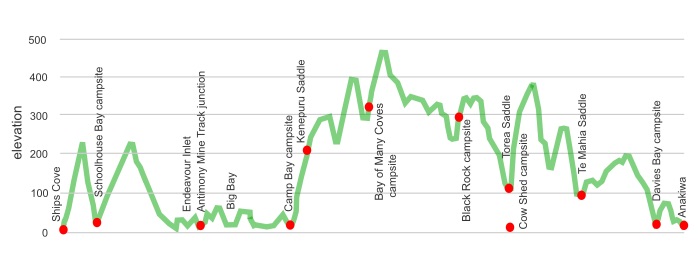
Here’s the DoC-stated tramping times between points, as shown on their website or from their signage, usually actual walking times, ie, not taking into account any long breaks. DoC bases its estimation on times for an “average” tramper which means that it’s possible to slash times for more vigorous walkers.
Unfortunately, this time information tends to emphasise a pointless aspect of tramping, The Destination, and, some trampers feel they need to test themselves, rush, to prove something to someone. Aren’t you there to experience your environment, notice things, go down to the beach or watch the bellbirds flitting around? There’s no actual requirement to occupy the full 10 hours a day racing through the landscape.
Ship Cove to School House campground
Time: 2 hours
Distance: 4.5 km
Schoolhouse campground to head of Endeavour Inlet
Time: 3 hours
Distance: 10.5 km
head of Endeavour Inlet to Camp Bay campground
Time: 3 hours 30 minutes
Distance: 11.5 km
Camp Bay campground to Bay of Many Coves campsite
Time: 3 hour
Distance: 3.4 km
Bay of Many Coves campsite to Black Rock campsite
Time: 3 hours
Distance: 8 km
Black Rock campsite to Torea Saddle
Time: 2 hours
Distance: 6.5 km
Torea Saddle to Cow Shed campsite
Time: 10 minutes each way
Distance: 600 m
Torea Saddle to Te Mahia Saddle
Time: 4 hours
Distance: 12.5 km
Te Mahia Saddle to Davies campsite
Time: 3 hours
Distance: 8 km
Davies campsite to Anakiwa
Time: 1 hours
Distance: 3.6 km
getting there | Queen Charlotte Track, Marlborough Sounds
The Cougar Line has water transfers get you to a variety of points along the track, leaving October to April at 8 and 10 am and 1 30 pm. Winter times, May to September, are 9 am and 1 30 pm. This includes transferring your luggage between your accommodation places. $5 extra for your bike.
Beachcomber Cruises offer a few options.
To walk the whole track their Ship Cove Track & Pack Pass that drops you off at Ships Cove. You make your own way from Anakiwa. Cost: $76 per adult, $52 if 14 – 5 years old. [2022] Departs 1 October to 30 April at 8 and 9 am. Remainder of the year just the 9 am departure.
There’s also a lazy Great Track and Pack Pass which will drop you off at Ships Cove, pick you up at the end at Anakiwa and shuffle your luggage between your various accommodation rooms. Cost: $107 per adult, $59 if 5-14 years old, [2022]. You are an adult quite early in life with this lot. Departs 1 October to 30 April at 8 and 9 am. The remainder of the year just the 9 am departure.
supplies | Queen Charlotte Track, Marlborough Sounds
Picton, population around 4,000, has a Fresh Choice supermarket, 7 am-9 pm, and a smaller 4 Square, 9 am-5 pm, Monday to Saturday, 10 am-4 pm Sunday.
Blenheim and Nelson have the usual major supermarkets, Countdown, New World, Pak’n’save for getting the main supplies. Shellite or Fuelite for your stove can be obtained at outdoor and hardware stores if you haven’t been allowed to fly with it. Certainly cheaper to stock up in these larger centres.
warnings | Queen Charlotte Track, Marlborough Sounds
This is about as risk-free a walk as you can do in the South Island, there are no tidal crossings, rivers, alpine passes, just a wide track that comes close to Great Walk standard.
The track surface is, however, predominantly yellow clay, which has a tendency to be slippery, particularly when damp.
Mountain bike riders enjoy the ride, often at a decent clip, and visibility is sometimes not too far ahead.
There is a requirement to pay a $25 multi-day access fee to traverse the private land that makes up about 30% of the track. There is a parking meter-style ticket dispenser at the southern end of the track, otherwise, you can obtain your ticket where you make your water taxi bookings.
This is not a track to choose if you are wanting to have a typical New Zealand tramping experience. There are too many mountain bikers, and their bikes, day walkers, boutique accommodation places, batches, lipstick wearers, cell phone addicts, etc.
Overall you will spend a fair amount of time climbing but overall the Queen Charlotte Track can be rated as: Unchallenging.
other websites | Queen Charlotte Track, Marlborough Sounds
DOC’s website about the Queen Charlotte Track.
There is an official DOC brochure.
Another informative website is run by a member-based marketing organisation for the Queen Charlotte Track.
a big image slideshow | Queen Charlotte Track, Marlborough Sounds
Here’s a 25 image slideshow from the Queen Charlotte Track giving an indication of the general track conditions and sights along the way, if you need any further convincing.
Click on the thumbnail image below to get the slideshow started, then you can click on the left or right sides of the bigger images to go forward or back.
Images of the Queen Charlotte Track campsites can be found in the other Te Araroa huts and campsites section.
