Few people venture into the western side of Nelson Lakes National Park. The Matakitaki River is the widest and longest in the park and leads up to iconic Bobs and East Matakitaki Huts.
Even fewer tackle the unnamed range on the west side of the Matakitaki.
This adventurous loop, only for super experienced trail finders, takes you to two seldom visited huts, linked by an exposed ridge that ventures above 2000 m for some astounding views in all directions, and a close inspection of the results of the Alpine Fault activity.
Other features:
The pre-1902 restored Downie Hut, an old musterers’ hut complete with 1930s graffiti from government hunters;
Old gold mining workings halfway up Burn Creek;
One of the most compact NZFS huts in fully original condition, ie, untouched for around 60 years. That’s Burn Creek Bivvy;
And one of the best sited small huts in the park, Nardoo, with its surrounding cliffs and adjacent tarns.
You are almost guaranteed to see deer and chamois.
Camp by an alpine tarn.
Plenty to like.
But! You need to read the warnings.
Trampers were writing in the hut book back in 1991 about the poor state of the track. It has not received any work since then in Burn Creek, and recent floods in Nardoo Creek have smashed out some track, and left plenty of uprooted trees in the riverbed.
The alpine section has a number of moments of peril for those who are unaccustomed to heights. It’s fully exposed up top to the vagaries of the weather, as is the creek travel sections where numerous creek crossings are required.
So, only for the experienced who are looking for a significant physical and mental challenge that will truly test their skills.
You were warned.
The only easy part of the circuit is from the car park to Downie Hut.
where | Burn/Nardoo Loop, Nelson Lakes National Park
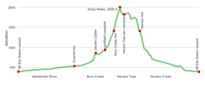
A loop around from the DOC Matakitaki River valley carpark, up the Matakitaki River valley to Burn Creek then over Emily Peaks to Nardoo Hut and down Nardoo Creek back to the carpark.
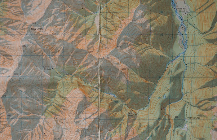
click to view larger, more interactive topographic map from, err, topomap.co.nz
distance | Burn/Nardoo Loop, Nelson Lakes National Park
55 km loop from/to the Mt Ella Station carpark
time | Burn/Nardoo Loop, Nelson Lakes National Park
4 days, with 3 nights at Downie, Burn Creek and Nardoo Huts
when | Burn/Nardoo Loop, Nelson Lakes National Park
Best when there are longer and warmer days, ie, the summer months, December to April.
Snow in winter and spring will make the Emily Peaks section dangerous and very hard work.
maps and GPS | Burn/Nardoo Creek Loop, Nelson Lakes National Park
Because the track is so poorly marked, both with signage along the way and the clarity of the path, having a paper map is useful. A track appears on old maps, but has been removed in recent LINZ maps. There’s no track once above the bushline, and a paper map is great if visibility is poor.
Here’s the track up Burn Creek as once marked, back in the day, ie, 1986. The track up until where you climb up to Jacobs Ladder is pretty well washed out in Burn Creek, but it’s easy enough to smash up the creek bed, crossing as required. A few dozen times. Once up above the Jacobs Ladder bluff follow the general route as shown here on the 1986 map, as that is where any remaining NZFS markers are.
Maps can be found at Land Information New Zealand, LINZ, Topo50 maps, both digital and paper: BS23 Matakitaki and BT23 Lewis Pass.
Download free digital versions from LINZ Mapchooser, or buy the real thing, ie, on old fashioned paper, at DOC offices, outdoor shops and bookshops where maps sold. There’s a nationwide list at LINZ Map Retailers.
Need a custom map for your GPS device, download a more compact .klm format file from topomap.co.nz for free, although if you download a few maps consider a small donation, there’s considerable work gone into getting that info onto the internet and we should support these useful resources.
route description | Burn/Nardoo Loop, Nelson Lakes National Park
Best to start this loop by going up to Downie Hut and cross the Matakitaki River near the hut. After rain this river is very hard to cross, it can become very big and then it’s super powerful. You can cross the vehicle bridge near the carpark on return from Nardoo Hut.
Easy walk to Downie Hut in the flat Matakitaki River valley. Cross the river close to the hut and head up on the true left side to Burn Creek. It is easier to cross the river there than further up. The walk up Burn Creek to the base of Jacobs Ladder is fairly straightforward. Just cross Burn Creek as required, maybe 20 times. You need to know which steep tributary to climb to get to the start of Jacobs Ladder. It’s very steep and washed out and immediately under the bluffs, just before where Burn Creek enters a gorge. About 80 or 100 m up there are NZFS markers on the true right of the creek, and cairns on the true left. You smash your way up through the regrowth while veering slightly to the right. There are plenty of white permolat markers to show the route up to the base of the Number 8 wire assisted climb. After that you are more or less on your own, with only a few markers, lots of regrowth and windfall to get through and around. Don’t climb too high, but keep above the bluffs, obviously. Stay on the true right of Burn Creek and cross a second washed-out tributary. You need to climb above a short gorge before you get to the old gold workings where there are decent campsites.
Follow up the creek bed until you get to a small waterfall and then climb up the steep bank on the true right where there are a few markers, that then come and go until you get to the open grassy area at the junction. A 9 kg gas bottle marks the point where you can climb down to cross the creek, then climb up adjacent to the waterfall to the top of the flat ridge, ie, only 50 or so metres. Then it’s a bush bash to get to the hut. There are quite a few markers, you just need to persevere. Remember the Forest Service dudes who created the track took the most straightforward route.
From Burn Creek Hut you can either go up the valley, where there is a 15 m waterfall to climb around, or up the ridge behind the hut. From the saddle on the ridge there is an easy climb to the westernmost Emily Peak, at 2024 m. From there follow down the ridge over to Point 1916 and continue over to Point 1786. Note there are some bluffs to work your way down. You need to get around the unnamed bump but at the saddle before Point 1840 you can drop down the slope towards a gut, hanging close to the right as you get towards the cliffs.
This is important. There is a short section immediately above a decent bluff that needs to be traversed. It is damp but there is flax to hang onto. Once you get past that it is a straightforward amble down to Nardoo Hut that you should already be able to see next to a tarn.
From the hut it is well marked to get down to the treeline, where the route is well marked with those orange triangles for all but 100 m near where you cross the river after the bend, due to windfall and regrowth. From there is is easy enough to smash your way straight down the river bed, crossing about 25 times before it flattens out and it become worth getting on the at times overgrown, but well enough marked track that turns into an old four-wheel-drive track. You can cross the Matakitaki River at the farm road bridge if required due to rain.
huts and campsites | Burn/Nardoo Loop, Nelson Lakes National Park
There are 3 huts along the route:
Good campsites in both Burn Creek and mid-Nardoo Creek:
Burn Creek goldfields campsite
And a big semi-sheltered tarn up on the Nardoo Tops:
Tramping times | Burn/Nardoo Loop, Nelson Lakes National Park
Not much DOC info on walking times, at least from Downie Hut to Burn Creek Hut to Nardoo Hut. Yeah, that’s the part you need.
Here’s some allowances you should make. Times for those two middle sections will depend greatly on your trail finding and mountain climbing abilities.
Ella Station DOC carpark to Downie Hut
Time: 5 hours
Distance: 17 km
Downie Hut to Burn Creek Hut
Time: a full day, 7 to 10 hours
Distance: 11 km
Burn Creek Hut to Nardoo Hut
Time: a full day, 6 to 10 hours
Distance: 9 km
Nardoo Hut Hut to Ella Station DOC carpark
Time: 7 hours 30 minutes
Distance: 18 km
getting there | Burn/Nardoo Loop, Nelson Lakes National Park
There’s no regular public transport anywhere near the Ella Station DOC carpark. This road is quite remote, 38 km from the highway, with half on a gravel road. Possible to hitch out with dairy workers if you want additional walking, but would be hard to get all the way in.
The DOC carpark is close to the Ella Station milking shed.
supplies | Burn/Nardoo Loop, Nelson Lakes National Park
Nelson, Richmond or Westport have the usual major supermarkets, either Countdown, New World, Pak’nsave, for getting the main supplies. Gas canisters, Shellite or Fuelite for your stove can be obtained at outdoor and hardware stores if you haven’t been allowed to fly with it.
Murchison has a small Four Square supermarket that has most of the basics, open 7 days from 8 30 am weekdays, 9 am weekends.
warnings | Burn/Nardoo Loop, Nelson Lakes National Park
Yeah, this is a big list. Plenty of peril on offer. It’s not a standard maintained DOC track.
Don’t attempt this unless you have had some serious off-track experience, because a lot is off-track of a fairly physical type.
Matakitaki River. This is one of the region’s biggest rivers, and can be a major issue to cross after rain. Don’t bother with this route unless the forecast is for good weather. A decent low water crossing point exists close to Downie Hut where there are a number of braids, and a gravel, not bouldery bottom. The only actual bridge is near the Mt Ella Station homestead a few hundred metres from the car park. Wise to start this tramp via Downie and Burn Creek so you won’t be trapped.
Creek sections. Both Burn Creek and Nardoo Creek require many river crossings, a few dozen each, and there are no swing bridges. It’s a dry weather circuit. Note that these creeks are very steep, and the flow can be stronger than you might imagine. The creeks can go down quickly however. The bottom part of the creeks are relatively easy travel.
Jacobs Ladder. When heading up Burn Creek you need to climb above some bluffs. Immediately before the bluffs climb about 80 m up the steep unnamed creek to the old white NZFS Venetian blind marker, also some mossy cairns on the true left of the watercourse. Then climb up the steep hillside on the true left, following the white permolat markers to a short and steep Number 8 wire section. That’s the top.
Unmaintained track. While the Burn Creek track was once fully marked with white Venetian blind NZFS markers and there is sometimes an almost discernible trail on the ground, the markers are sporadic at times. Actually much of the time. The problem is the regeneration of the red beech saplings due to the reduction in deer numbers that has allowed the undergrowth to make a major comeback. This makes it difficult to pick up the “trail” when you skirt around windfall, or encounter regrowth. Hint: keep as low as possible, generally. After all, the miners didn’t like putting in any unnecessary effort. If you are befuddled, it can waste huge amounts of time.
Crossing Burn Creek gorge. There’s an old 9 kg gas bottle that indicates the climb down to the river at the western end of the clearing above the creek junction. This ain’t for the fainthearted. Climb up to the top of the flat ridge immediately adjacent to the waterfall. Yes, really!! The track up to the hut from the main creek junction is well overgrown.
The Emily Peaks tops route. This climbs up to around 2000 m. It is very exposed to the weather. Can be disorientating when in the clouds. Obviously no markers whatsoever. Few people walk this.
Climbing exposure. While this route is generally okay for experienced trampers, there are many bluffs, and the possibility of getting into difficulty if you choose your route badly. Note it is difficult to see the best route down from above. There are a few potentially perilous sections of exposure. It is possible to go up Upper Burn Creek to get to the saddle to the south of Emily Peaks, but there is a 15 m waterfall to climb around. Adjacent to the flow, the bedrock is potentially slippery. This valley is a clear avalanche danger in winter/spring. However, the route is more direct than climbing the ridge starting from the hut. On the north side of Emily Peaks follow the steep ridge down to avoid bluffs. Yeah, it’s steep. The route down from the ridge near Point 1652 to Nardoo Hut is not obvious due to bluffs. Two possibilities. The safer option is to continue west past Point 1786 over the next bump, then sidle under Point 1840 to the head of the basin. The shorter, more direct route heading down the first gully past the unnamed bump leads to a steep gut, with a short section needing to be negotiated above a considerable drop. Sufficient flax to provide an element of support. This would feel very much safer ascending. You can see the hut about 15 minutes away. There are other odd steep bits, including a steep rocky scree slope, that also require negotiation. Experienced trampers will have little issue with the obstacles, but this is no place for the timid. Getting from Burn Creek Hut to Nardoo Hut involves about 1400 m of climbing and descent. It’s a big day out.
Nardoo Creek. The drop down to the creek, and getting around the bend is steep, but mostly well marked. Once around the corner it is quicker to just follow the river bed, rock hopping, and fallen tree avoiding, crossing the creek a couple of dozen times. Much of the river flats have been severely damaged by recent floods, although there are some good camping places towards the bend. Note there are some massive cliffs where it is required to cross the creek. Towards the bottom it becomes apparent that it is easier to walk on longer stretches in the forest, although often reasonably marked, the regenerating red beech may slow progress.
Winter/spring. With the river crossings and possibilities of snow this is clearly best in the summer/early autumn. There are plenty of areas of steep snow grass where any snow would be potentially slippery. In bad weather: forget it. Burn Creek above the hut is a major avalanche risk during winter and spring.
DOC times. Some of the DOC or published times are optimistic for many. The seven hours from the Matakitaki River crossing up to Nardoo Hut stated on the sign is actual walking time for super experienced and fit trampers, with the creek levels low. Many would take ten hours, particularly if carrying a heavy pack. Near the bend there are some areas where the track is hard to follow due to regrowth. That climb up to Nardoo Hut from the creek is a gut buster.
Finally. This is a route that few people attempt. No one made an entry in the Burn Creek hut book in 2018. There was a four-year vacancy from 2002 – 2006. The route in Burn Creek is a serious challenge to follow. The Matakitaki River is one of the biggest in the region and is usually a task to cross.
And yeah, having negotiated this loop successfully you may well look as if you have been trapped in a cage with feral cats for a number of days considering the lacerations on your arms and legs. This is not a route for the inexperienced.
other websites | Burn/Nardoo Loop, Nelson Lakes National Park
DOC has nothing.
a big image slideshow | Burn/Nardoo Loop, Nelson Lakes National Park
Here’s a 50 image slideshow from Burn/Nardoo Loop giving an indication of the general track conditions and sights along the way, if you need any further convincing.
Click on the thumbnail image below to get the slideshow started, then you can click on the left or right sides of the bigger images to go forward or back.

Images of the Burn/Nardoo Loop huts and campsites can be found in the Nelson Lakes National Park huts.