Those who are evolving webbed feet will enjoy this track. Other hardy souls may as well.
The track as far as Port Craig is popular enough, walking near and at times along a sandy beach. Some regenerating forest to enjoy. Port Craig has plenty of artifacts from its seven-year service as a milling settlement where hundreds of people once lived and worked. The investors in the venture became bankrupt as the trees were fewer in number, and far smaller in size than anticipated, and the amount invested in infrastructure considerable.
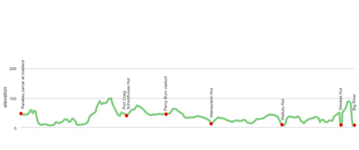
The track to Wairaurahiri is along an old tramline that smashes its way across the country with four massive timber viaducts over some substantial ravines. The bridge at Percy Burn is 35 m above the creek, 10 stories high, and is an impressive engineering feat.
What could be easier than walking along a railway gradient?
The following day is a slugfest on the way to Waitutu Hut, a true festival of the bog. Then a mostly great walk to the remarkable hut in a cave called Westies. Certainly, one of the zaniest huts DOC administers. A great view from the window of the southern ocean doing its thing. Then it’s only an hour or so over to Big River where time, but not the sandflies, stands still. From there it’s a repeat of the experience, this time in reverse.
Why do it?
Well, for those seeking solitude this track is not usually overly populated. The huts are spacious, except for Westies, and well-spaced.
It’s kind of North West Circuit-lite. No ferry trip required, and fewer ups and downs, some history, and of course some mud to splash around in. All rivers and large streams are bridged.
So, it’s a good winter alternative tramp. No avalanches or snow.
And, of course, you feel like you are on the perimeter of the known world.
where | South Coast Track, Fiordland
Heading west along the south coast of the South Island starting 26 km west of Tuatapere.
click to view larger, more interactive topographic map from, err, topomap.co.nz
distance | South Coast Track, Fiordland
61 km, Rarakau carpark one way to Big River, then double that when you return
time | South Coast Track, Fiordland
8-9 days if you stay at each hut
when | South Coast Track, Fiordland
Anytime the weather is good, but probably best when there are longer days, ie, the summer months, November to April.
OK in winter as there are no mountains to produce avalanches, and the three big rivers have swing bridges. Many bigger creeks have viaducts, or swing bridges.
maps and GPS | South Coast Track, Fiordland
It’s useful to have a paper map in case GPS batteries die.
Land Information New Zealand, LINZ, Topo50 maps, both digital and paper: CG06 Long Point, CG07 Long Hill Point.
Download free digital versions from LINZ Mapchooser page 28, or buy the real thing, ie, on old-fashioned paper, at DOC offices, outdoor shops and bookshops where maps sold. There’s a nationwide list at LINZ Map Retailers.
Need a custom map for your GPS device, download a more compact .klm format file from topomap.co.nz for free, although if you download a few maps consider a small donation, there’s considerable work gone into getting that info onto the internet and we should support these useful resources.
route description | South Coast Track, Fiordland
The huts are relatively evenly spaced, at least time-wise, but each day brings some variety.
To Port Craig is Great Walk standard with some beach walking in a few ups and downs. To Wairaurahiri the track is on an old tram line, ie, mostly flat with four big historic viaducts. To Waitutu is boggy for the first two-thirds then generally excellent walking. To Big River feels more remote, but is the most interesting forest and general scenery.
Then you get to revisit the countryside as you retrace your steps.
Sounds easy when you write it like that, although it is around 120 km of walking.
huts and campsites | South Coast Track, Fiordland
There is no shortage of huts along the way. Port Craig Schoolhouse Hut is popular in the warmer months as a short trip destination, but the others are often little used. The campsite at Big River is unofficial, but a goodie. Finding other campsites is not so easy, due to the prevalent crown fern and generally damp ground conditions.
tramping times | South Coast Track, Fiordland
Here’s the DOC stated tramping times between huts, as shown on their website, usually actual walking times, ie, not taking into account any long breaks. DOC bases its estimation on times for an “average” tramper, which means that it’s possible to walk somewhat faster. On this track, there is considerable variation between the stated DOC times and what it would actually take, usually less. Some are way out, others close.
Unfortunately, this time information tends to emphasise a pointless aspect of tramping, The Destination, and, some trampers feel they need to test themselves, rush, to prove something to someone. Aren’t you there to experience your environment, notice things, experience the views, and watch the bellbirds flitting around? There’s no actual requirement to minimise the time racing through this memorable landscape.
carpark to Port Craig Schoolhouse Hut
Time: 7 hours
Distance: 18 km
Port Craig Schoolhouse Hut to Wairaurahiri Hut
Time: 3 – 4 hours
Distance: 9 km
Wairaurahiri Hut to Waitutu Hut
Time: 7 – 8 hours
Distance: 15.5 km
Waitutu Hut to Westies Hut
Time: 5 – 6 hours
Distance: 19 km
Westies Hut to Big River campsite
Time: 1 – 2 hours
Distance: km
getting there | South Coast Track, Fiordland
There is no public transport to the start of the track. You are better driving there, or trying your luck hitchhiking.
supplies | South Coast Track, Fiordland
Invercargill has a big New World, Pac’n‘save, and two Countdown supermarkets, open 7 days, 8 am — 12 pm.
Tuatapere has a well-stocked Four Square supermarket, open 7 days, 7 30 am — 9 pm.
warnings | South Coast Track, Fiordland
Old paper maps will show Westies Hut in an incorrect position.
A well enough marked track, although when wading through thigh-deep ferns it pays to keep an eye open for DOC markers. Still, over the years the track has been well smashed out so if you keep your eyes open you should be okay. The main issue is if there is a tree across or along the track and you need to pick it up on the other side.
The main rivers have swing bridges, and they need them as they flow from huge lakes further upstream. Many of the smaller creeks have swing bridges as well. One three-wire bridge to negotiate. Having the wire between the heel and the sole of your boot helps, as does shuffling sideways across the wire.
Occasional steep slippery stretches but not often full-on.
The big section of bog between Wairaurahiri Hut and Angus Burn can be slow going for those unaccustomed to such travel. Highly recommended to wear decent gaiters, and also overtrou. Yeah, gaiters will enhance your experience an enormous amount by stopping your boots from filling up with stinking murk.
As mentioned the biggest issue is the location of Westies Hut. It is not where indicated on older maps, but is almost exactly 1 km further to the west, in a direct line. The turnoff is clearly marked on the track and comes after a scramble up a steep slope that may be assisted by the rope that has been provided. The drop-down to the hut is steep-ish, but manageable.
Westies Hut itself is Robinson Crusoe-style rather than DOC built. The accommodation for one is okay, at least those for those without the olfactory sense. While there are also bunks in the outhouse they are rudimentary. It is well positioned and appointed but it ain’t a palace, despite the carpet and embossed wallpaper.
For those unaware, this is a relatively gloomy corner of New Zealand. Bring some warm clothes that you keep dry for wearing the huts. Your other set are sure to get wet.
Oh, and sandflies. But you know about those. This particular brand of sandfly will test your patience however.
The Rarakau carpark is shared with those on the Hump Ridge Track and seems there are generally cars around. It’s nowhere near any passing traffic, being at the end of a section of gravel road. Cars may be safer here than at more public carparks near busy roads.
other websites | South Coast Track, Fiordland
DOC has a webpage for the South Coast Track.
a big image slideshow | South Coast Track, Fiordland
Here’s a 57 image slideshow from the South Coast Track giving an indication of the general lack of track conditions and sights along the way, if you need any further convincing.
Click on the thumbnail image below to get the slideshow started, then you can click on the left or right sides of the bigger images to go forward or back.

Images of the South Coast Track huts and campsite can be found in the Southland/Fiordland huts and campsites section.