Probably the gnarliest of the major named tracks accessible from Queenstown.
Why?
The access, the terrain, and the distances between the huts.
If you want an easier option try the Caples/Greenstone circuit.
A major bonus is the daytrip on offer to the astonishing Cascade Saddle. Worth the effort.
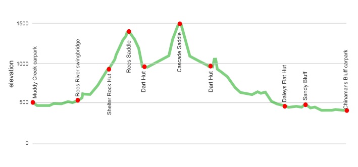
The Rees Dart has a variety of landscapes. Easy travel over river flats, some great track through forests, a few ups and downs through avalanche country, the rugged views from Rees Saddle, the track above the chasm of Snowy Creek cutting between Mt Tewha, 2510 m, and Mt Cunningham, 1963 m, some big drop-offs down the Dart River bluffs, a new lake created by a massive landslide. Add in the ice cliffs of the Marshall Glacier, and the major Dart Glacier itself on your way up to Cascade Saddle, with a big Matukituki River valley way below, big cliffs around, the 200 m drop of the Heads Leap waterfall, and Mt Aspiring, 3033 m, on view. You then have a semi-demanding 10 km trek back to the hut.
Set aside five days, and plan on having much of the time in motion.
The huts are decent, with a few acceptable campsites at each hut.
Even a massive rock bivvy or two if you prefer more oxygen exposure while you sleep.
Some downsides:
The awkward access to the trailheads, although a shuttle service from Queenstown or Glenorchy is on offer. Hitching is a possibility in the busier months due to the tourists from Queenstown having few roads to test their driving skills, and driving to the end of the road being A Thing.
Those with a fear of heights should avoid this track. There is a few instances of sidling on seemingly steep scree slopes with substantial drop-offs to hurtful places down the hill, particularly with the old track hacked in the rock climbs high above the new lake at the benignly named Sandy Bluff. The drop-off is 50 m+, and you are wandering on a narrow ledge with varying degrees of exposure for around 200 m in length. That may boost your adrenaline levels.
And yeah, you need to carry five days’ food, cooking equipment, etc.
So you may find you collapse onto your plastic-encased mattress feeling you put in a decent day’s effort.
One additional major note of warning. Due to the major avalanche risk and the removal of the footbridge over Snowy Creek, this is definitely not a winter/spring tramp. Much of the area before Shelter Rock Hut, around to Dart Hut, and of course Cascade Saddle can be affected by big-time avalanches. The bridge is returned when the DOC avalanche assessors deem the track safe.
where | Rees-Dart Track, Mt Aspiring National Park
You zip around Mount Earnslaw/Pikirakatahi, 2819 m, at the head of Lake Wakatipu, near Queenstown.
click to view larger, more interactive topographic map from, err, topomap.co.nz
distance | Rees-Dart Track, Mt Aspiring National Park
61 km, Muddy Creek carpark one way to Chinamans Bluff carpark.
30 km by unsealed road between Muddy Creek and Chinamans Bluff car parks.
time | Rees-Dart Track, Mt Aspiring National Park
4 days if you stay at each of the three huts, plus one additional day for Cascade Saddle daytrip
when | Rees-Dart Track, Mt Aspiring National Park
The summer to late autumn months, November/early December to May.
Not advisable in winter to early summer as there is serious avalanche risk, and the Snowy Creek bridge is removed.
maps and GPS | Rees-Dart Track, Mt Aspiring National Park
No real need to have a paper map version on this track. The track is very well marked and the NZ Topo50 app on your phone is sufficient detail.
If you are venturing off the track you may prefer a paper version.
The Newtopo Rees Dart map shows the track on waterproof paper. Cost: $24.
Land Information New Zealand, LINZ, Topo50 maps, both digital and paper: CA10 Lake Williamson, CB10 Glenorchy.
Download free digital versions from LINZ Mapchooser Te Anau, or buy the real thing, ie, on old fashioned paper, at DOC offices, outdoor shops and bookshops where maps sold. There’s a nationwide list at LINZ Map Retailers.
route description | Rees-Dart Track, Mt Aspiring National Park
It makes sense to start at the Rees River end and enjoy the views up the valley to Mt Head, 2585 m, and the Grant Glacier as you mooch along. (The Dart end pickup at 2 pm works out as well.) The Rees valley starts easily enough with sometimes damp farmland, but once crossing the Rees River swingbridge enters the forest of Mount Aspiring National Park. About Shelter Rock Hut the track gets above the bushline, and crosses Rees Saddle, 1477 m, before sidling above Snowy Creek to Dart Hut. The long descent of the Dart River is relatively easy, although there are some scree slopes and Sandy Bluff to get around and those unaccustomed to heights may experience perilous moments.
huts and campsites | Rees-Dart Track, Mt Aspiring National Park
There are three huts along the track, and Earnslaw Hut is a short climb. Each of the three huts has acceptable campsites, at least for the unfussy. Plenty of unofficial campsites in the Dart River valley, but it isn’t allowed to camp on the Rees River farmland, or between the Shelter Rock and Dart Huts.
Backcountry Hut Passes can only be used in the three serviced huts from 1 May to 30 September. Can use for camping.
Backcountry Hut Passes cannot be used from 1 October to 30 April. Cost for this period is $20 and you need to buy tickets before you go.
tramping times | Rees-Dart Track, Mt Aspiring National Park
Here’s the DOC stated tramping times between huts, as shown on their website, usually actual walking times, ie, not taking into account any long breaks. DOC bases its estimation on times for an “average” tramper, which means that it’s possible to walk somewhat faster. On this track there is considerable variation between the stated DOC times and what it would actually take, usually less. Some are way out, others close.
Unfortunately, this time information tends to emphasise a pointless aspect of tramping, The Destination, and, some trampers feel they need to test themselves, rush, to prove something to someone. Aren’t you there to experience your environment, notice things, experience the views, and watch the bellbirds flitting around? There’s no actual requirement to minimise the time racing through this memorable landscape.
Muddy Creek carpark to Mt Aspiring National Park boundary
Time: 4 – 5 hours
Distance: 12 km
Mt Aspiring National Park boundary to Shelter Rock Hut
Time: 2 – 3 hours
Distance: 7 km
Shelter Rock Hut to Dart Hut
Time: 4 – 6 hours
Distance: 10 km
Cascade Saddle daytrip
Time: 4 – 5 hours each way
Distance: 10 km each way
Dart Hut to Daley Flat Hut
Time: 5 – 7 hours
Distance: 18 km
Daley Flat Hut to Chinamans carpark
Time: 5 hours 30 minutes – 7 hours 30 minutes
Distance: 16 km
getting there | Rees-Dart Track, Mt Aspiring National Park
Info & Track are the only company that has scheduled transport to the start of the track and this runs during the official DOC “summer season”, ie, late October to late April. They leave from Queenstown, 8 am, 12 15 pm, $63 adult/$43 child, or Glenorchy, 9 15 am for Rees end, 1 15 pm for Dart end, $39 adult/$27 child. Dart pick up time is 2 00 pm. They need to be chartered outside these weeks. Check that there are seats, the shuttle buses aren’t that big, ie, book ahead.
You can drive and leave your car at the carpark at Muddy Creek or Chinamans Bluff, but it is 30 km between the two carparks, and that is a real issue. Better to leave your car at Glenorchy and pay $39 each way with Info & Track. Always possible to try your luck hitchhiking.
supplies | Rees-Dart Track, Mt Aspiring National Park
Queenstown has a big New World, Pak’n‘Save, FreshChoice, and Countdown supermarkets, most open 7 days, 7 am — 11 pm.
Glenorchy has Mrs Woolly’s General Store with expensive gourmet groceries supermarket, open 7 days, 9 am — 6 pm. The Trading Post is more of a cafe.
warnings | Rees-Dart Track, Mt Aspiring National Park
The winter/spring avalanche danger is very real. There is a lengthy section from before Shelter Rock Hut to Dart Hut that clearly has avalanches on a regular basis during this period.
The footbridge over Snowy River is removed during the possible avalanche season. This river would be very dangerous to cross in its absence. Check with DOC that this has been repositioned, usually in early November/December.
Better just note the trampers die in the New Zealand high country each year through poor decisions, particularly in winter.
The Snowy River section between Rees Saddle and the Dart Hut has some short sections on loose scree with some exposure to falling if care is not taken. Similarly Sandy Bluff on the Dart River has a next narrow rocky track with a significant drop alongside to be negotiated. There is no alternative so if you don’t like major heights this may not be the track for you.
The final climb from the Dart River valley floor to the Cascade Saddle has some stretches of loose gravel, it is a glacial moraine wall, in fact, much of the climb is super loose underfoot. The streams carve out the gravel so the track is marked by cairns each year. With all the ice around the wind can be surprisingly chilly.
The distance between the huts is considerable so a good standard of fitness is useful.
DOC times indicate common walking times for fit people, so if you stop frequently this should be added to the stated time. It’s not easy to cut hours off if you’re carrying a heavy pack.
The huts are large, Dart Hut is 36 bunks, but at peak times, January/February, it may be prudent to carry a tent unless you prefer to sleep on the kitchen floor.
You are allowed to camp anywhere along the track, except the Rees River flat farmland, and from Shelter Rock Hut over to Dart Hut.
Most of the streams are bridged, but a few on the south side of Shelter Rock Hut would be dangerous to cross due to their steepness, if the water levels are up significantly.
You may get your car trapped at Chinamans Bluff if the small streams on the road from Paradise rise significantly. Best to check the long-term weather forecast before parking.
Not a track for a beginner to tramping, it’s reasonably physically demanding, and the track although substantially benched isn’t of Great Walk standard. While usually easy enough to follow it has some moments that may concern some carrying a pack, particularly getting in and out of the creek beds.
other websites | Rees-Dart Track, Mt Aspiring National Park
DOC has a webpage for the Rees-Dart Track.
a big image slideshow | Rees-Dart Track, Mt Aspiring National Park
Here’s a 57 image slideshow from the Rees-Dart Track giving an indication of the general lack of track conditions and sights along the way, if you need any further convincing.
Click on the thumbnail image below to get the slideshow started, then you can click on the left or right sides of the bigger images to go forward or back.

Images of the Rees-Dart Track huts and campsite can be found in the Queenstown area huts and campsites section.