Five big turquoise lakes, and a few smaller.
Gently rolling countryside with a backdrop of the Southern Alps.
Sounds idyllic.
Yes, siree.
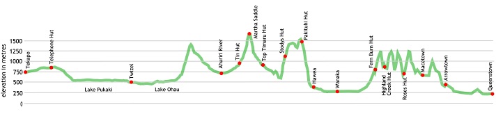
On the other hand, there’s also the 800 m climb from Lake Ohau to the unnamed pass into the East Ahuriri River valley, Martha Saddle, 1680 m, the Timaru River. The Motatapu Track is surprisingly vigorous with around 3000 m climbing involved between Glendhu Bay and Arrowtown.
No doubt this section has the best supplies, you pass through Tekapo, Twizel, Hāwea, Wanaka, Arrowtown and Queenstown.
where | Tekapo to Queenstown — Te Araroa
Tekapo to Queenstown, via Lake Pukaki, Twizel, Lake Ohau, the Ahuriri River, Martha Saddle, Timaru River, Lake Hāwea, Lake Wanaka, the Motatapu Track, etc.
click to view larger, more interactive topographic map from, err, topomap.co.nz
distance | Tekapo to Queenstown — Te Araroa
329 km Tekapo to Queenstown, almost 7000 m ascent/descent
time | Tekapo to Queenstown — Te Araroa
possible in 12 days for the energetic, many take about 16
when | Tekapo to Queenstown — Te Araroa
November to April inclusive.
maps and GPS | Tekapo to Queenstown — Te Araroa
It’s essential to have a paper map in case GPS batteries die.
Most people get by with the generally useful maps supplied free for download from the Te Araroa Trust website. These have sufficient detail to find your way. Download and print out your own on a colour laser printer, bubble jet maps don’t survive getting wet at all well. There is a habit of maps being annotated as the track is walked and being passed to those heading in the opposite direction, showing camping site recommendations, etc.
There are also .kmz or .gpx files for free download for your GPS device at the Te Araroa Trust website. And the up to date trailnotes.
There are Land Information New Zealand, LINZ, Topo50 maps, both digital and paper, but at $7 each they get expensive and some parts of the track cross only small sections of map.
Download free digital versions from LINZ Mapchooser, or buy the real thing, ie, on old fashioned paper, at DOC offices, outdoor shops and bookshops where maps sold. There’s a nationwide list at LINZ Map Retailers.
Need a custom map to print off or for your GPS device, download a more compact .klm format file from topomap.co.nz for free, although if you download a few maps consider a small donation, there’s considerable work gone into getting that info onto the internet and we should support these useful resources.
route description | Tekapo to Queenstown — Te Araroa
This section starts with a relatively easy walking section on roadsides and gravel roads from Tekapo to past Lake Ohau.
Once out of the forest above Lake Ohau the route become harder to follow, there are sporadic markers over to the Ahuriri River through the tussock, you just follow the route on the map. After crossing there’s more old farm track over Martha Saddle until after Top Timaru Hut.
Then, back in the forest there’s another climb past Stodys Hut into more tussock past Pakituhi Hut and down to Lake Hāwea. Then it’s easy going once again until the start of the Motatapu Track.
The Motatapu is surprisingly strenuous, all climbing and descent, over to Arrowtown. Then it’s manicured bike trails and footpaths into Queenstown.
huts | Tekapo to Queenstown — Te Araroa
You will be spending many nights in your tent on this section, not so many huts along the way. These are the huts you are likely to encounter:
Fern Burn Hut | Mt Soho Station Pastoral Lease
Highland Creek Hut | Mt Soho Station Pastoral Lease
Macetown campsite | Arrow River near Arrowtown
Pakituhi Hut | Hāwea Conservation Area
Roses Hut | Mt Soho Station Pastoral Lease
Stodys Hut | Hāwea Conservation Area
The Pines freedom campsite | Lake-Pukaki-Reserve
Top Timaru Hut | Hāwea Conservation Area
Tramping times | Tekapo to Queenstown — Te Araroa
Here’s the DoC stated tramping times between huts, as shown on their website, usually actual walking times, ie, not taking into account any long breaks. DoC bases its estimation on times for an “average” tramper which means that it’s possible to slash times for more popular sections. With more remote sections the stated time is close to the actual time required.
Some of the times have been taken from the Te Araroa Trust website.
SH8 opposite Ruataniwha Rd at Twizel to Glen Mary Ski Club at Lake Ohau
Time: 8-9 hours
Distance: 33 km
Glen Mary Ski Club at Lake Ohau to Birchwood carpark
Time: 8-10 hours
Distance: 24 km
Birchwood Carpark to Top Timaru Hut
Time: 7-8 hours
Distance: 22.8 km
Top Timaru Hut to Timaru River Junction
Time: 5-6 hours
Distance: 12 km
Timaru River Junction to Stodys Hut
Time: 1.5-2 hours
Distance: 2.2km
Stodys Hut to Pakituhi Hut via Breast Hill
Time: 3.5-4.5 hours
Distance: 11.2 km
Pakituhi Hut to Gladstone Reserve
Time: 3-4 hours
Distance: 5.1 km (950 m climb from Lake Hāwea if coming north)
Gladstone Reserve to Lake Hāwea Township
Time: 1.5-2 hours
Distance: 6.8 km
Lake Hāwea Township to Clutha River Bridge
Time: 2.5-3.5 hours
Distance: 12 km
Clutha River Bridge to Wanaka CBD
Time: 3-4 hours
Distance: 12 km
Wanaka CBD to Glendhu Bay
Time: 4 hours
Distance: 15 km
Glendhu Bay to Fern Burn carpark
Time: 45 minutes
Distance: 3 km
Fern Burn carpark to Fern Burn Hut
Time: 3 hours
Distance: 7 km
Fern Burn Hut to Highland Creek Hut
Time: 4 hours
Distance: 6 km
Highland Creek Hut to Roses Hut
Time: 5-6 hours
Distance: 11 km
Roses Hut to Macetown
Time: 4-5 hours
Distance: 10 km
Macetown to Arrowtown
Time: 4-5 hours
Distance: 12 km
Arrowtown to Queenstown
Time: 5-6 hours
Distance: 21 km
getting there | Tekapo to Queenstown — Te Araroa
Tekapo is more accessible being on the run to Queenstown and Mt Cook. There are a number of buses each day but the cheaper two are: Intercity leaving Christchurch at 8 30 am and arriving at 12 00 noon, and departing Tekapo at 12 40 pm arriving in Christchurch at 4 30 pm for around $35 if you can book ahead.
Atomic does the same run at different times: departing Christchurch at 7 30 am arriving Tekapo at 10 40 am. And departing Tekapo at 6 05 pm arriving in Christchurch around 9 45 pm, all for $30.
There’s plenty of means to get to Queenstown.
Getting around by hitching is also possible but, of course, entirely unreliable.
supplies | Tekapo to Queenstown — Te Araroa
Resupply is easier on this leg of Te Araroa: you pass through Tekapo, Twizel, Hāwea, Wanaka, Arrowtown, and Queenstown.There’s a reasonable 4 Square Supermarket in Tekapo in the main street open 7 days: 7 00 am – 8 00 pm. You can get most common groceries needed for food resupply there.
Twizel has two 4 Square supermarkets that offer most of what you might need, Monday – Saturday: 7 00 am – 8 30 pm, Sunday 7 30 am – 8 00 pm.
Hāwea has a small grocery store.
Wanaka, permanent population 6,000, has a large New World supermarket in the main shopping street. Open 7 days, 7 30 am – 9 00 pm.
Arrowtown has a small grocery store that would rate as one of the world’s most expensive. Certainly cheaper to stock up in Wanaka or Queenstown.
Queenstown has the usual major supermarket, Wakatipu New World, but it is located in Frankton just past the airport, 7km from downtown Queenstown, open 8 am to 9 pm, also seven days. There’s a bus out there. Freshchoice, open 7 am to midnight seven days, a kilometre from the centre on the Arrowtown road, is big enough to stock most items you would need at a significantly more competitive price than the Alpine Store right in town.
There are many shops in Queenstown selling Shellite or Fuelite and gas canisters for your stove: Alpine Sports, Outside Sports, H & J’s Outdoor World, Kathmandu and Macpac. There is also a big Mitre 10 which might be the cheapest option.
warnings | Tekapo to Queenstown — Te Araroa
The Ahuriri River crossing is probably the major concern on this section, although the small rivers can become torrents and while they come up quickly they can go down just as fast.
Due to the newness of the track some new sections are still relatively poorly marked in the tussock: the section between Lake Ohau and the Ahuriri River is the main problem zone.
Note that while these tracks are relatively low, due to New Zealand’s island climate it is possible to get snow to low levels even in mid-summer. In the summer of 2014 — 15 it snowed below 1000 m three times in January/February. It can get cold and combined with strong winds the wind chill factor can be much more extreme than you might think.
New Zealand does not have a stable continental style climate as is found in Europe or North America, one thing you can rely on is that it is quite unpredictable. A day can start without a cloud, have horizontal rain in 20 minutes and the temperature drop 10º C very quickly. Good wet weather gear and warm clothes are essential.
Carrying an EPIRB, ie, an emergency locator beacon, is a sensible idea here, there may not be so many people out here on any particular day.
other websites | Tekapo to Queenstown — Te Araroa
The official Te Araroa website has a welter of information and maps and trail notes, suggestions for commercial accommodation, and hints, etc.
a big image slideshow | Tekapo to Queenstown — Te Araroa
Here’s a 49 image slideshow from Tekapo to Queenstown giving an indication of the general track conditions and sights along the way, if you need any further convincing.
Click on the thumbnail image below to get the slideshow started, then you can click on the left or right sides of the bigger images to go forward or back.

Images of this section of Te Araroa huts and campsites can be found in the Te Araroa huts and campsites section.