Variety of landscapes?
This is the section of Te Araroa where you get the full smorgasbord.
Ship Cove/Meretoto to a Boyle Village has it all: a water taxi ride to the start of the track; the water views of the Marlborough Sounds from high on the Queen Charlotte Track; the pristine Pelorus River, well, up beyond the farms; the high-level undulations of the Alpine Route; Lake Rotoiti and Blue Lake, the clearest fresh water in the universe, apparently; the epic day getting over Waiau Pass, the second highest point on Te Araroa; and, to finish, half the easy-going St James Walkway.
Once you get into the beech forest past Pelorus Bridge there are comfy huts at regular intervals, four hours apart usually, at least until the big Waiau Pass day.
But note there is a fair level of effort required for the section, and not so much in the way of supplies available, just the Havelock supermarket and New Zealand’s, if not the world’s, most expensive small grocery store in St Arnaud. And there is little in the way of village at Boyle Village, no shop at all, although the Outdoor Centre will hold a food parcel for you at a cost of $10. That means that you usually are lugging plenty of food.
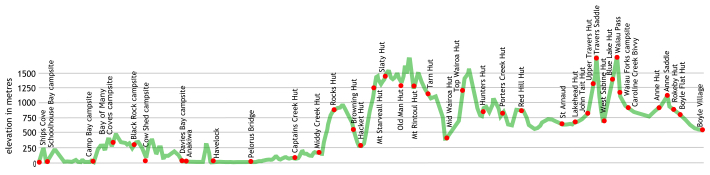
The track is relatively easy to follow but it has its moments: the 1300 m climb to Mount Starveall, the 220 m scramble down a steep and gnarly slope between Little Rintoul and Mt Rintoul, heading up the Wairoa River, eight river crossings required and a few steep drops to negotiate, climbing up and over Waiau Pass. Plenty of excitement there.
An excellent introduction to the South Island for the adventurous.
where | Ship Cove/Meretoto to Boyle Village — Te Araroa
Ship Cove/Meretoto at the northern end of Queen Charlotte track, the Pelorus River and along the ridges of the Richmond Range to St Arnaud. Then across the Nelson Lakes National Park, that includes Travers Saddle and Waiau Pass and onto the easier St James Walkway.
click to view larger, more interactive topographic map from, err, topomap.co.nz
distance | Ship Cove/Meretoto to Boyle Village — Te Araroa
356 km Ship Cove/Meretoto to Boyle Village, around 13,000 m ascent
time | Ship Cove/Meretoto to Boyle Village — Te Araroa
possible in 20 days for energetic hut jumpers, many take about 26
when | Ship Cove/Meretoto to Boyle Village — Te Araroa
November to April inclusive.
maps and GPS | Ship Cove/Meretoto to Boyle Village — Te Araroa
It’s essential to have a paper map in case GPS batteries die.
Most people get by with the generally useful maps and up-to-date trail notes supplied free for download from the Te Araroa Trust website. These have sufficient detail to find your way. Download and print out your own on a colour laser printer, bubble jet maps don’t survive getting wet at all well. There is a habit of maps being annotated as the track is walked and being passed to those heading in the opposite direction, showing camping site recommendations, etc.
There are also .kmz or .gpx files for free download for your GPS device at the Te Araroa Trust website.
There are Land Information New Zealand, LINZ, Topo50 maps, both digital and paper, but at $7 each they get expensive and some parts of the track cross only small sections of the map.
Download free digital versions from LINZ Mapchooser, or buy the real thing, ie, on old-fashioned paper, at DOC offices, outdoor shops, and bookshops where maps sold. There’s a nationwide list at LINZ Map Retailers.
Need a custom map to print off or for your GPS device, download a more compact .klm format file from topomap.co.nz for free, although if you download a few maps consider a small donation, there’s considerable work gone into getting that info onto the internet and we should support these useful resources.
route description | Ship Cove/Meretoto to Boyle Village — Te Araroa
The track starts on the undulating Queen Charlotte Track then into the attractive Pelorus River Valley, climbs over Totara Saddle, and over to Hacket Hut. Then the unrelenting 1300 m climb starts up to Mt Starveall Hut before you oscillate around the 1500 m mark on open ridge tops, a few scrambly bits, the most demanding being the 220 m drop down of Little Mt Rintoul and another 500 m scree slope that is easier to negotiate to Mt Rintoul Hut. Great views from there. Then you are back in the forest, mostly, and follow more ridges before dropping into the Wairoa River at Mid-Wairoa Hut. There are 8 river crossings of the Wairoa River before you finally climb out just before Top Wairoa Hut. Speaking of climbing you then climb over another saddle and drop down to Hunters Hut. There’s just a bit of up and down on the way to Red Hills Hut from where you drop into the Wairau Valley. The last bit is a road slog for about 10 km to St Arnaud, there’s even a hill to climb. PS, you can hitch this bit if not a purist.
From St Arnaud the route follows the well-used Travers/Sabine Track around Lake Rotoiti, up the Travers Valley to Travis Saddle, 1785 m, dropping 1000 m on the other side to the Sabine Valley and to Blue Lake.
The longest and potentially most difficult day for Te Araroa in the South Island is the day over Waiau Pass to the new Waiau Hut. From there it is a relatively easy walk to Boyle Village via the pleasant St James Walkway.
huts | Ship Cove/Meretoto to Boyle Village — Te Araroa
There are plenty of huts in Mt Richmond Forest Park, Nelson Lakes National Park, and the St James Walkway. These are the ones you are likely to encounter along the way.
Bay of Many Coves campsite | Queen Charlotte Track, Marlborough Sounds
Black Rock campsite | Queen Charlotte Track, Marlborough Sounds
Blue Lake Hut | Nelson Lakes National Park
Boyle Flat Hut | St James Walkway
Browning Hut | Mt Richmond Forest Park
Camp Bay campsite | Queen Charlotte Track, Marlborough Sounds
Captain Creek hut | Mt Richmond Forest Park
Caroline Creek Bivvy | Waiau River, North Canterbury, has been removed, and you now need to head south for another hour to the new Waiau Hut.
Cowshed Bay campsite | Queen Charlotte Track, Marlborough Sounds
Davies Bay campsite | Queen Charlotte Track, Marlborough Sounds
Emerald Pool campsite | Mt Richmond Forest Park
Hacket Hut | Mt Richmond Forest Park
Hunters Hut | Mt Richmond Forest Park
John Tait Hut | Nelson Lakes National Park
Lakehead Hut | Nelson Lakes National Park
Magdalen Hut | St James Walkway
Mid Wairoa Hut | Mt Richmond Forest Park
Middy Creek Hut | Mt Richmond Forest Park
Mt Rintoul Hut | Mt Richmond Forest Park
Old Man Hut | Mt Richmond Forest Park
Porters Creek Hut | Mt Richmond Forest Park
Red Hills Hut | Mt Richmond Forest Park
Rocks Hut | Mt Richmond Forest Park
Roebuck Hut | Mt Richmond Forest Park
Schoolhouse Bay campsite | Queen Charlotte Track, Marlborough Sounds
Slaty Hut | Mt Richmond Forest Park
Starveall Hut | Mt Richmond Forest Park
Tarn Hut | Mt Richmond Forest Park
Top Wairoa Hut | Mt Richmond Forest Park
Upper Travers Hut | Nelson Lakes National Park
Waiau Forks campsite | Nelson Lakes National Park
Waiau Hut | St James Conservation Area
West Sabine Hut | Nelson Lakes National Park
Tramping times | Ship Cove/Meretoto to Boyle Village — Te Araroa
Here’s the DoC stated tramping times between huts, as shown on their website, usually actual walking times, ie, not taking into account any long breaks. DoC bases its estimation on times for an “average” tramper which means that it’s possible to slash times for more popular sections. With more remote sections the stated time is close to the actual time required.
Some of the times have been taken from the Te Araroa Trust website.
Ship Cove to School House campground
Time: 2 hours
Distance: 4.5 km
Schoolhouse campground to head of Endeavour Inlet
Time: 3 hours
Distance: 10.5 km
head of Endeavour Inlet to Camp Bay campground
Time: 3 hours 30 minutes
Distance: 11.5 km
Camp Bay campground to Bay of Many Coves campsite
Time: 3 hour
Distance: 3.4 km
Bay of Many Coves campsite to Black Rock campsite
Time: 3 hours
Distance: 8 km
Black Rock campsite to Torea Saddle
Time: 2 hours
Distance: 6.5 km
Torea Saddle to Cow Shed campsite
Time: 10 minutes each way
Distance: 600 m
Torea Saddle to Te Mahia Saddle
Time: 4 hours
Distance: 12.5 km
Te Mahia Saddle to Davies campsite
Time: 3 hours
Distance: 8 km
Davies campsite to Anakiwa
Time: 1 hours
Distance: 3.6 km
Anakiwa to Havelock
Time: 4-5 hours
Distance: 16.7 km
Havelock to Pelorus Bridge
Time: 5.5— 7 hours
Distance: 25.2 km
Pelorus Bridge to Pelorus roadend
Time: 3 — 4 hours
Distance: 13 km
Pelorus roadend to Captain Creek Hut
Time: 4 hours
Distance: 8.5 km
Captain Creek Hut to Middy Creek Hut
Time: 2 hours
Distance: 5 km
Middy Creek Hut to Rocks Hut
Time: 3 hours
Distance: 5 km
Rocks Hut to Browning Hut
Time: 4.5 hours
Distance: 11 km
Browning Hut to Hacket Junction
Time: 1 hour
Distance: 3.4 km
Hacket Junction to Hacket Hut
Time: 15 minutes (and a further 5.7 km if starting from the Hacket roadend).
Distance: 1.3 km
Hacket Hut to Starveall Hut
Time: 4 hours
Starveall Hut to Slaty Hut
Time: 2 hours 30 minutes
Slaty Hut to Old Man Hut
Time: 5 hours
Distance: 10 km
Old Man Hut to Rintoul Hut
Time: 5 hours
Distance: 4.5 km
Rintoul Hut to Tarn Hut
Time: 4.5 hours
Distance: 8 km
Tarn Hut to Mid Wairoa Hut
Time: 4 hours
Distance: 6.5 km
Mid Wairoa Hut to Top Wairoa Hut
Time: 4.5 hours
Distance: 7 km
Top Wairoa Hut to Hunters Hut
Time: 5 hours
Distance: 10.5 km
Hunters Hut to Porters Creek Hut
Time: 4 hours
Distance: 9 km,
Porters Hut to Red Hills Hut
Time: 5 hours
Distance: 10.5 km
Red Hills Hut to SH 63
Time: 1.5 hours
Distance: 5.5 km
SH 63 to St Arnaud (along road)
Time: 2.5 – 3 hours
Distance: 10.6 km
St Arnaud to Lakehead Hut
Time: 3 hours
Distance: 9 km
Lakehead Hut to John Tait Hut
Time: 5 hours
Distance: 12 km
John Tait Hut to Upper Travers Hut
Time: 3 hours
Distance: 6 km
Upper Travers Hut to West Sabine Hut
Time: 6–8 hours, depending on conditions
Distance: 8 km
West Sabine Hut to Blue Lake Hut
Time: 3 hours
Blue Lake Hut to Upper Waiau Forks campsite
Time: 6 — 8 hours
Distance: 7 km
Upper Waiau Forks campsite to Caroline Creek Bivvy
Time: 3 hours
Distance: 5 km
Caroline Creek Bivvy to Anne Hut
Time: 7 — 9 hours
Distance: 25 km
Anne Hut to the Boyle Flats Hut
Time: 7.5 hours
Distance: 17 km
Boyle Flat Hut to Boyle Village
Time: 4 hours
Distance: 14.5 km
getting there | Ship Cove/Meretoto to Boyle Village — Te Araroa
You need to jump on a boat to get to Ship Cove/Meretoto.
Beachcomber Cruises offers their Ship Cove Track & Pack Pass at beachcombercruises.co.nz/qct-walks/great-track-pack-pass/ship-cove-track-pack-pass/ that drops you off at Ships Cove. Cost: $71 per adult, $45 if 14 – 5 years old. Departs 1 October to 30 April at 8 and 9 am, remainder of the year just the 9 am departure.
The Cougar Line has a service at queencharlottetrack.co.nz/timetable/#times1 for $80 one way, leaving October to April at 8 00 am, 10 00 am, 1 30 pm & 6 00 pm. Winter times, May to September, are 9 00 am, 1 30 pm, (& 5 30 pm on Friday).
East West Coaches bus departs Westport at 8 00 am, arriving Boyle Village at 10 20 am, or, departing Christchurch at 2 00 pm and arriving at 4 30 pm. Phone 03 789 6251, or 0800 142 622 for further information and pricing.
Getting around by hitching is also possible but, of course, entirely unreliable. There’s an okay hitching spot at the highway at the end of the walkway.
supplies | Ship Cove/Meretoto to Boyle Village — Te Araroa
Picton, population around 4,000, has a Freshchoice supermarket, 7 00 am-9 00 pm, and a smaller 4 Square, 9 00 am-5 00 pm, Monday to Saturday, 10 00 am-4 00 pm Sunday.
Nelson, Blenheim and Richmond have the usual major supermarkets, Countdown, New World, Pak’nsave for getting the main supplies. Shellite or Fuelite and gas canisters for your stove can be obtained at outdoor and hardware stores in Nelson or Blenheim, if you haven’t been allowed to fly with it.
The small store at St Arnaud usually has a reasonable, if expensive, supply of food and basic camping needs, matches, candles, gas canisters, Fuelite, etc, and operates normal business hours, seven days a week.
From the other direction, Christchurch has the works of course. Hamner Springs has two supermarkets, The Hamner Four Square in Conical Hill Road, open 7 days, most 8 30 am to 6 pm, and the Hamner Springs Foodway in Amuri Avenue open 7 days, 9 00 am to 5 00 pm.
warnings | Ship Cove/Meretoto to Boyle Village — Te Araroa
Weather good: no problem, at least for those who don’t mind the occasional gnarly challenge.
On the other hand, the conditions can turn horrendous real quick, then it’s a hugely different story. A day can start well enough and then speedily deteriorate to immensely heavy rain, or even snow, at any time of year. Then you have a major issue, particularly on those long, super exposed ridges where the wind can hammer in, 100 kph+ common enough and that ain’t good, even for the well prepared. Having adequate wet weather gear, ie, a proper storm coat and overtrou is essential equipment.
With rain, the water levels can rise surprisingly quickly, but luckily it can dissipate in a hurry as well. There are a couple of unbridged crossings of what are usually small creeks in the Pelorus, Browning Creek can rage, and there are a number of crossings of Hacket Stream prior to the big climb. Later there’s eight crossings of the Wairoa River but the track has been recently recut to avoid the crossing that used to be immediately above a 4 m waterfall. Actually, there are a few stretches of track that care needs to be taken in the wet, due to the steep 20 m dropoffs. This is a section where if the river is raging it is best to bunker down for a day until the river goes down, the river is steep so it doesn’t take long after the rain stops.
The 220 m drop off Little Mt Rintoul, ie, the officially unnamed hill to the north of the actual Mt Rintoul, is the most heart rate increasing part of the track, it is, err, steep, and there is nothing to hang onto. If travelling in a group make sure that people don’t roll any head-sized boulders down on those below. Remember though, many people have walked through here, most survive.
Overall this is a big step up in the level of difficulty and exertion required from the Great Walks, and even from a track like the Travers-Sabine Circuit, there are bigger, harder climbs and descents, many of the rivers have no bridge, and you can get yourself in a power of difficulty if you misjudge the conditions. But sometimes we need more of a physical challenge, this fits the bill for people wanting to give themselves a decent test.
Carrying an EPIRB, ie, an emergency locator beacon, is a sensible idea here, there may not be so many people out here on any particular day.
blogs | Ship Cove/Meretoto to Boyle Village — Te Araroa
I haven’t found many engaging blogs about this particular route, but my own blog starts here: Ship Cove/Meretoto to Boyle Village — Te Araroa blog
“Another beaut day, do I need to say much more?
OK, so there are many with fresher legs who cruise through the Alpine Route in half the time, jumping huts big time, long days spent dancing over the rocks and up-and-down slopes, busy getting somewhere else in a huge hurry. For me, at least this first trip over the Alpine Route, with the weather fantastic except for that rest day I spent Old Man hut with the wind whistling around, and maybe that first mizzly morning climbing up the fire track to hit the Dun Mountain trail, you might as well revel in the opportunity and make the most of the experience. If I came through again it will almost certainly be completely different, ie, not perfect weather, or with another person and the logistics then changes, and in any case I prefer any other trip to be in the opposite direction.”
There’s also Nicky and Cookie’s hugely entertaining account, with excellent accompanying images, as part of their Te Araroa wander in the summer of 2010, this route starts when you click through to Crisscrossing Hacket Creek.
Writing this a few days later it’s all a bit of a blur of sweat, tears, fears, cuts and bruises. But, in a way, it was awesome. Awesome in the way that you truly appreciate being alive! Awesome, in the way that you achieved something you never thought possible. And awesome in the way that you’ve experienced something hardly anyone in the world has. I’d say that makes it worth it.
But enough of that. Let’s get back to the horror! ;)
Little Rintoul is a mass of loose rock, sharp scree, very very steep exposed slopes, and boulder fields. When you climbed the boulders, they wobbled. Their rough volcanic surfaces grating your legs as you tumbled around them, sticks clattering. When you climbed the ridges, there were steep steep drop-offs for hundreds of meters, and brittle ledges of slate you hoped would take your weight as you shimmied round clinging on, butt swaying in the wind, fingernails clamped in and curling under your grip. When you sidled the slopes of loose scree the depth was thin, not enough to kick a step, or wedge a boot, just to press your foot flat and pray the marble-like balls of rock wouldn’t slide out from under you before you had the chance to place the next step. The perspiration was of a different sort today – pure fear!
other websites | Ship Cove/Meretoto to Boyle Village — Te Araroa
The official Te Araroa Trust website has plenty of info and track notes.
a big image slideshow | Ship Cove/Meretoto to Boyle Village — Te Araroa
Here’s a 38 image slideshow from the Alpine Route giving an indication of the general track conditions and sights along the way, if you need any further convincing.
Click on the thumbnail image below to get the slideshow started, then you can click on the left or right sides of the bigger images to go forward or back.

Images of the Alpine route huts can be found in the Te Araroa huts and campsites section.