Hands up those who think this is the best long distance tramp in New Zealand.
Where else can you wander around a remarkably scenic coastline untroubled by too many people, actually often no one else, no cars, no roads, no powerlines, no fences, no farm stock, no planes flying overhead, no screen interfaces, no internet or cell phone connection, often, basically no civilisation in toto except what you can carry on your back, for many days, even a week or two? A track where there are no high mountain passes, or fast flowing mighty river torrents, to traverse and even the legendary endless river of mud seems not so troubling when in amongst it, for the most part.
And unlike other great seaside hiking experiences around the world this one has no highly venomous snakes, as on the southwest track in Tasmania, or rampaging bears, as in North America. Not even leeches.
No worries.
The North West and Southern Circuit tracks are, however, quite the challenge, primarily because of the distance, together with the need to trudge burdened, at least initially, with a food load for the complete journey, the weather, although that may prove more mild than you might imagine, and, for some anyway, the isolation.
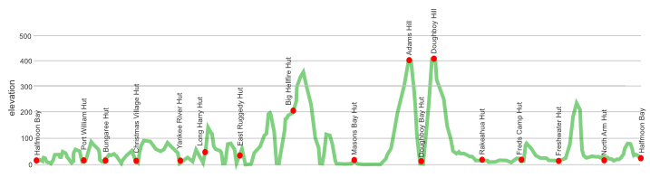
Let’s face it, there aren’t many places on Earth, like standing on Doughboy Hill, ie, a bump on the ridge between Doughboy and the Rakeahua valley, where you can look south over to the vast and empty of humanity Tin Range, and realise you might be the last person between civilisation and Antarctica.
Yeah, this is truly a trip to the perimeter of the inhabited world.
where | North West + Southern Circuit – Rakiura National Park, Stewart Island
an anti-clockwise circuit from civilisation in Oban around the coast to Masons Bay then either cutting back inland towards Oban via Freshwater Landing, the standard North West circuit, or continuing on to Doughboy Bay and then getting to Freshwater Landing via the Rakeahua valley.
In the longer days in summer it is possible to jump some huts but this becomes more difficult when the days shorten during winter.
click to view larger, more interactive topographic map from, err, topomap.co.nz
distance | North West + Southern Circuit – Rakiura National Park, Stewart Island
181 km – from/to Oban
time | North West + Southern Circuit – Rakiura National Park, Stewart Island
13 – 15 days — it’s a biggy
when | North West + Southern Circuit – Rakiura National Park, Stewart Island
Anytime?
Yes, the walk around the coast is at low level, obviously, the sea moderates the temperatures to a large degree so, believe it or not, it doesn’t really matter that much when you go despite being at 47º S. The rainfall is relatively consistent throughout the year, with perhaps surprisingly, July, August and September being the less wet months. But despite it raining on average every second day the total yearly rainfall in Oban, 930 mm, is less than that of Auckland or Wellington, so it rains often, but not for too long.
Daylight can be an issue: you get a whole lot in summer, no chance of Vitamin D deficiency then, it can be light enough to wander around at 10pm, on 21 December sunrise is 5 50 am, sunset is 9 40 pm, a day length of almost 16 hours.
In winter on the shortest day, 21 June, the sun rises at 8 30 am and sets at 5 05 pm, a day length of only about 8.5 hours. That means you need an early start on the big days cranking the seven hours from East Ruggedy to Hellfire Pass, or the next day another seven hours from Hellfire to Mason Bay.
Moral of the story, you can basically go at any time of the year, just take your chances.
maps and GPS | North West + Southern Circuit – Rakiura National Park, Stewart Island
It’s essential to have a paper map in case GPS batteries die.
Land Information New Zealand, LINZ, Topo50 maps, both digital and paper: CH08 Codfish Island (Whenuahou), CH09 Mount Anglem/Hananui, CJ08 Doughboy Bay, CJ09 Mount Allen, and maybe the little bit of Oban which is found on CJ10 Port Adventure.
Download free digital versions from LINZ Mapchooser, or buy the real thing, ie, on old fashioned paper, at DOC offices, outdoor shops and bookshops where maps sold. There’s a nationwide list at LINZ Map Retailers.
Need a custom map for your GPS device, download a more compact .klm format file from topomap.co.nz for free, although if you download a few maps consider a small donation, there’s considerable work gone into getting that info onto the internet and we should support these useful resources.
route description | North West + Southern Circuit – Rakiura National Park, Stewart Island
Anti-clockwise is the way to go. The track then starts with a few easier stretches of track and builds to bigger days once the tide level on the food supplies has dropped, and you’ve become used to trudging for long periods of time through the mud.
huts | North West + Southern Circuit – Rakiura National Park, Stewart Island
Here’s the huts you will encounter in Rakiura National Park.
Camping really is only for the hardy due to the often soaked substrate and the extra bulk and weight of a tent on a 125 km wander is unnecessary when there will often be no one else in the huts. If you want some adventure why not stay in one of the caves at the north end of West Ruggedy Beach or Doughboy Bay instead.
There’s also the two caves:
Tramping times | North West + Southern Circuit – Rakiura National Park, Stewart Island
Here’s the DoC stated tramping times between huts, as shown on their website, usually actual walking times, ie, not taking into account any long breaks. DoC bases its estimation on times for an “average” tramper which means that it’s possible to slash times for more popular sections near Oban. With more remote sections the stated time is close to the actual walking time required. When they state 7 hours at East Ruggedy Hut, or Hellfire Pass Hut they mean it, unless you run.
Unfortunately this time information tends to emphasise a pointless aspect of tramping, The Destination, and, some trampers feel they need to test themselves, rush, to prove something to someone. Aren’t you there to experience your environment, notice things, see the waves crashing, watch the bellbirds flitting around? There’s no actual requirement to occupy the full ten hours a day racing through the landscape.
Halfmoon Bay to Port William Hut
Time: 4 hours
Distance: 12 km
Port William Hut to Bungaree Hut
Time: 3 – 4 hours
Distance: 6 km
Bungaree Hut to Christmas Village Hut
Time: 6 hours
Distance: 11.5 km
Side trip – Christmas Village Hut to Mt. Anglem/Hananui
Time: 6 hours return
Distance: 5.5 km
Christmas Village Hut to Yankee River Hut
Time: 6 hours
Distance: 12 km
Yankee River Hut to Long Harry Hut
Time: 5 hours
Distance: 8.5 km
Long Harry Hut to East Ruggedy Hut
Time: 5 – 6 hours
Distance: 9.5 km
East Ruggedy Hut to Hellfire Pass Hut
Time: 7 – 8 hours
Distance: 14 km
Hellfire Pass Hut to Mason Bay Hut
Time: 7 hours
Distance: 15 km
Mason Bay Hut to Doughboy Bay Hut
Time: 6 – 7 hours
Distance: 18 km
Doughboy Bay Hut to Rakeahua Hut
Time: 7 – 8 hours
Distance: 16 km
Side trip – Mt. Rakeahua
Time: 5 hours return
Distance: 4.5 km each way
Rakeahua Hut to Fred’s Camp Hut
Time: 5 hours
Distance: 12 km
Fred’s Camp Hut to Freshwater Hut
Time: 5 hours
Distance: 10 km
Side trip – Rocky Mountain Track
Time: 3 hours return
Distance: 5 km
Freshwater Hut to North Arm Hut
Time: 6 – 7 hours
Distance: 11 km
North Arm Hut to Halfmoon Bay
Time: 4 hours
Distance: 12 km
getting there | North West + Southern Circuit – Rakiura National Park, Stewart Island
Here’s a suggestion: take the ferry across to build up the suspense and then fly back when you can identify where you have been from the air. And you then won’t have to worry about the 15 kg baggage limit.
Flying: Three flights a day, at slightly varying times depending on the season, 365 days a year, from Invercargill airport to the strip on Stewart Island. The flight takes 20 minutes and can give a good overview of the island. There’s a minibus to take passengers to/from the Oban Post Office which is included in the fare. Fares: adult return $220, one way $130, with a variety of others depending on passenger’s age. Baggage limit: 15 kg, now that’s a problem when you are heading to the island because you really need to travel with all your kilos of food. Phone Stewart Island Flights on 03 218 9129.
Ferry: The express catamaran ferry is now owned by Real Journeys which has connecting buses to Invercargill, Queenstown and Te Anau. The trip takes about one hour from Bluff to Oban. There’s daily ferries, with more than one on many days but it’s a mighty complicated schedule and fare structure, Adult: $85 (one-way) $148 (return, Child: $43 (one-way) $74 (return). There’s also a connecting bus from Invercargill with each ferry for an additional $26 each way.
supplies | Northwest + Southern circuit – Rakiura National Park, Stewart Island
Invercargill, population 53,000, has the usual major supermarkets, Countdown, New World, Pak’nsave for getting the main supplies. Shellite or Fuelite for your stove can be obtained at outdoor and hardware stores if you haven’t been allowed to fly with it.
The small Ship to Shore Four Square supermarket, at Oban, population around 400, has a reasonable, if expensive, supply of food and basic camping needs, matches, candles, Fuelite, etc, and operates normal business hours, seven days a week.
warnings | North West + Southern Circuit – Rakiura National Park, Stewart Island
There is no ATM/money machine in Bluff, or on Stewart Island, remember you are venturing to the edge of the Earth.
Heavy rain and strong winds can occur at any time of the year, which can have two effects. The track can be muddy in places and while the mud is legendary it is often is not as bad as you might think, pack those gaiters and waterproof overtrousers.
The track can flood in places, more like a rising tide and having to wade through a shallow lake than a raging torrent. In any case care should be taken and if in doubt spend an extra day in Masons Bay Hut until the flood recedes.
Getting from Mason Bay to Freshwater can involve long periods of wading through cool waters, trying not to fall off the duckboards you can’t quite make out in the gloomy water.
The Southern circuit is particularly prone to flooding: the area around Rakeahua Hut is able to hold water for some days after heavy rain, ie, flood, as is the flat area between Fred’s Camp and Freshwater.
Care is needed at the north end of Masons Bay at high tide although a track has been cut around the problematic bluff.
Oh, better say this, this is a big, big walk, over 180 km over quite demanding, up and down terrain, and you need to take all your provisions for up to two weeks on your back from Day One. Good luck.
other websites | North West + Southern Circuit – Rakiura National Park, Stewart Island
There’s a few websites about tramping around Stewart Island.
DOC has a pdf brochure with useful information including
The DOC North west circuit site has fairly extensive information, including brief track notes from hut to hut.
DOC also have a blurb about the Southern Circuit.
And, lastly, my blog of this full circuit starts here, plenty of discussion about my impressions but not a whole lot of specific track information. I guess the thought is that plenty of people have tramped around here in the past, you will probably make it too and it’s better, in my opinion, not to have too complete a picture of what it’s like before you get there.