Weather good: a fantastic two days.
Weather bad: don’t even think about it.
The issue is this: one day of Fiordland-style rain can make the route impassable, ie, rain can be heavy, 200 mm plus in a day, more than 500 mm in 24 hours has been recorded at nearby Milford Sound, the water channelled into the creeks and down the valleys, with the result — substantial flooding.
The flood detritus at the Lake Alabaster Hut gives some indication of the extremes experienced here, there’s plenty of vegetative flotsam in a band 4 m above the standard lake height, making for easy firewood gathering.
In drier conditions you can walk around much of Lake Alabaster, although at the northern end it’s easiest just to take to the water, wading knee deep for an hour or so. The alternative is a bushbash, the old lakeside track is almost completely overgrown and the markers, mostly, removed. The main problem in the wet is three gnarly river crossings, Diorite Stream, that’s not a braided creek, it would fill up bank to bank 3 m deep in a flash, the Barrier River, which at least comes in various streams and the Pyke River itself, that can quickly become a bigtime thundering river with full sized trees bumping down, and none of these have bridging. It’s easy to get trapped on the wrong side of the creek.
The positive news is that the track was re-marked in early 2014 so the trail finding is no longer as much of an issue, at least for the experienced in the forest, ie, much of the way. The open areas with the huge toi toi, that’s cutty grass to those unfamiliar with the serrated edged leaves that can slash your hands, and flax clumps are more problematic. There’s nothing to hang the standard orange plastic markers on so you have to make do with occasional plastic ribbon or a fibreglass pole with faded orange colouring, hardly visible amongst the flax stalks.
Be warned, this is not a track for the inexperienced, or for those who fail to recognise when it is prudent to have an alternative route arrangement, or sensible to turn back, or just bunker down to let the rivers go down.
_ Note that in recent years this has become one of the great pack rafting rivers in conjunction with the Hollyford River. You zip down the Hollyford River to Martins Bay Hut, and carry your pack raft around to Big Bay Hut. Then it is three hours over to the Pyke River that flow south and you get halfway up the Hollyford. They carry their pack raft back to the roadend. That has made the Pyke River way more accessible._
where | Pyke – Big Bay Route, Pyke Forest
The Pyke – Big Bay Route can turn the Hollyford Track into a circuit, starting at Lake Alabaster Hut, the second hut from the roadend and finishing at Martins Bay Hut, ie, the endpoint of the Hollyford.
There is a significantly better chance of not being trapped by flooding if the track is started from Lake Alabaster. See the warning section below to find out why.
click to view larger, more interactive topographic map from, err, topomap.co.nz
distance | Pyke – Big Bay Route, Pyke Forest
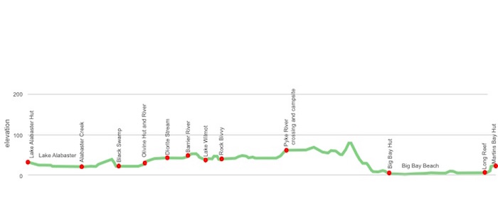
Lower Hollyford Road to Lake Alabaster Hut 19.5km
Lake Alabaster Hut to Big Bay hut via Olivine Hut 48 km
Big Bay Hut to Martins Bay Hut 12km
time | Pyke – Big Bay Route, Pyke Forest
3 days Lake Alabaster to Martins Bay Huts, ie, nights in Olivine and Big Bay Huts
when | Pyke – Big Bay Route, Pyke Forest
Anytime. Yup, indeedy.
Well, anytime when the weather is fine. Make sure you check the long range weather forecast to ensure there is a low probability of flooding rain. Heavy rain can make the track impassable.
Winter is surprisingly the time of least rain, June, July and August, although the duration of sunlight ain’t the best. February is the driest month on average but, then again, March is the wettest. You just take your chances, you can get floods at any time of year.
One thing, the track is not affected by avalanches due to the low altitude.
maps and GPS | Pyke – Big Bay Route, Pyke Forest
It is definitely worth carrying the Land Information New Zealand, LINZ, Topo50 map, CA09 Alabaster Pass as a minimum, the major proportion of both tracks are on that single map. If you need the lot there’s the issue that small sections of the Hollyford Track are found on CA08 Milford Sound/ Piopiotahi, around Martins Bay, and CB09 Hollyford, the start.
You could download free digital versions from LINZ Mapchooser and print out the bits you need. Or buy the real thing, ie, on old fashioned paper, at DOC offices, outdoor shops and bookshops where maps sold. There’s a nationwide list at LINZ Map Retailers.
Need a custom map for your GPS device, download a more compact .klm format file from topomap.co.nz for free, although if you download a few maps consider a small donation, there’s considerable work gone into getting that info onto the internet and we should support these useful resources.
route description | Pyke – Big Bay Route, Pyke Forest
The Pyke Big Bay Route can turn the Hollyford Track into a circuit. Starts at Lake Alabaster Hut, the second hut from the roadend and finishes at Martins Bay Hut, ie, the endpoint of the Hollyford.
There are two lakes to get around, or through, but overall the track is the flattest in New Zealand.
huts | Pyke – Big Bay Route, Pyke Forest
The Hollyford Track huts are comfortable enough, the mattresses are okay, the fireboxes work, the roof keeps the water out, what’s to complain about?
Here’s the DOC huts you will encounter:
The Lake Wilmot bivvy is not much in the way of shelter at all.
There is also a great campsite area adjacent to the Pyke River at Paulin Creek, for use in fine weather only. Technically you can camp anywhere but the reality is that there are few dry campsites around due to the damp and tussocky nature of the river flats.
There are also the nearby huts on the Hollyford Track:
There’s a simple and small, ie, inadequate, shelter at the roadend. You are not officially permitted to stay there.
tramping times | Pyke – Big Bay Route, Pyke Forest
Here’s the DOC stated tramping times between huts, as shown on their website, usually actual walking times, ie, not taking into account any long breaks. These are long days but with an early start, ie, first light, it is entirely possible to get between the huts in daylight, at least when there is longer hours of daylight in the summer months.
These times are pre-track re-marking, in dry conditions, the lower estimates are entirely reasonable, provided you are capable of following the minimal track markings in the toi toi. Wet conditions will slow you right down, particularly at river and creek crossings.
Lower Hollyford Road shelter and carpark to Lake Alabaster Hut
Time: 5 – 7 hours
Distance: 20 km
Lake Alabaster Hut to Olivine Hut
Time: 7 – 10 hours
Distance: 16 km
Olivine Hut to Pyke River crossing campsite
Time: 6 – 9 hours
Distance: 21 km
Pyke River crossing campsite to Big Bay Hut
Time: 3 – 5 hours
Distance: 15 km
Big Bay Hut to Martins Bay Hut
Time: 4 – 5 hours
Distance: 16 km
Then? Well, depends on your choice of return to civilisation. See Hollyford Track for alternatives.
getting there | Pyke – Big Bay Route, Pyke Forest
Trips and Tramps do a scheduled run from Te Anau to Milford Sound six days a week, all year around, except when the Milford Road is officially closed in winter, and will drop you off, 17 km down at the end of the fully gravel Lower Hollyford Road for $60. Book early to confirm place.
Trips and Tramps also do a fly-in package, doing a circuit from Te Anau, for $305 in the summer months, ie, fly into Martins Bay from Milford Sound, get picked up at the road end. Minimum of two people and it usually runs every second day, unless weather conditions don’t permit flying. Note, the pilots are experienced in flying in typical Fiordland conditions in a small plane and this short flight may be some of the more exciting moments of your life. It is also possible to do this in reverse, ie, drive in, fly out.
Tracknet have scheduled services seven days a week during the summer season, leaving from Queenstown, 6 55 am, or Te Anau, 11 00 am, and getting to the roadend around 1 00 pm, plenty of time to get to Hidden Falls Hut and see the features along the way, ie, Humboldt Falls and Hidden Falls. Cost: $55. They have other charters that you may be able to join as well. Tracknet picks up from the roadend on these days at, err, 1 00 pm.
Hitching is possible despite the remoteness of the cul-de-sac, Humboldt Falls is one of the attractions of the full Milford excursion for many tourists and it’s right at the end of the road. Hitching is also possible, if not entirely ideal, at the junction with the Milford Road, but only, realistically, to Te Anau, the other side of the road to Milford is on a big bend with limited visibility and no safe stopping possible.
supplies | Pyke – Big Bay Route, Pyke Forest
Te Anau has one major supermarket, Freshchoice, open 7am to 9pm seven days, for getting the main supplies. There is also a small 4 Square with similar, but marginally truncated opening hours.
Shellite or Fuelite and gas canisters for your stove can be obtained at Outdoor Sports, Fiordland Frontier Supplies, both open Monday – Friday 9.00am–5.30pm and Saturday 9am-1pm, or Mitre 10, Monday – Friday 8am-5.30pm, Saturday 9am-4pm, Sunday 11am-3pm, if you haven’t been allowed to fly with it. All these shops are in the main shopping area of Te Anau.
warnings | Pyke – Big Bay Route, Pyke Forest
The Pyke – Big Bay Route is the most dangerously flood prone of any of the tramps documented on this website.
So the Pyke – Big Bay Route can flood, ie, become completely impassable. The river crossings are a major issue as there is only a couple of bridges over two minor creeks, the big rivers do not have bridges.
The better direction to walk is from Lake Alabaster, mainly to do with avoiding being trapped by flooding. And we are talking being trapped for, sometimes, many days on the wrong side of a big flooded river with very poor shelter, no place to pitch a tent.
There are two main obstacles in getting to Olivine Hut. The first is wading around the edge of Lake Alabaster. When the lake level is low it should be possible to walk on gravel rather than bush bash when leaving from Lake Alabaster Hut for the first hour. Even with the lake at a low ebb wading at the northern end, around knee deep at best, is required, ie, plenty. When the tide level is higher the depth where wading will be correspondingly higher. It is possible to bush bash but the old track around the lake, remnant of the old stock track, has had the markers removed and has been totally overgrown in the last 30 years, except for a few short sections around bluffs.
The second issue is Alabaster Creek at the head of the lake. If Alabaster Creek is in flood, ie, unable to be crossed safely, it is then relatively easy to return safely to the Lake Alabaster Hut. Alabaster Creek is best crossed right where it runs into the lake. There is one bridge over a small creek before Olivine Hut. One of the Pyke experiences is crossing Black Swamp, no idea why it is called that, but progress is made by leaping from flax clump to clump, but it’s only about 15 minutes extra toil.
From Olivine Hut there is a cableway, basically a big bucket on a wire, you haul yourself across high above the river. Not long after leaving the Hut is a small creek but Diorite Creek, less than an hour from the hut might be the most awkward of all the crossings due to the confining banks and it verges on waist deep even in drought conditions. If crossing is unsafe it’s relatively speedy to return to Olivine Hut and wait it out for the creek to drop. Barrier River has more water but it is a braided river, you can pick the safest spots to cross each of the three or four streams.
There is some quicksand-style stinky mud at the south end of Lake Wilmot where a slip has occurred, best to scramble across the fallen trees however awkward it looks.
If you can cross the Pyke, knee deep if dry weather, there will be little to slow you to Big Bay but the Pyke has an enormous catchment and can rage through here 3 m deep at times. It is entirely possible to get trapped between the Pyke and Barrier River hence the necessity to monitor the weather conditions, there is little shelter here. If it is flooded you’d better call Noah, actually the “bivvy” site one of the few places that won’t get flooded. And it doesn’t come close to being accurately described by the adjective horizontal.
The reason to walk the Lake Alabaster–Olivine–Big Bay direction is that the more perilous river crossings, Barrier and particularly Diorite are met early in the day when fresh, rather than encountered at the end of a long slog. You can also make the decision at Lake Alabaster about the state of the weather, if it’s good then do it.
The Awarua River just before Big Bay is entirely tidal. Either cross just upstream from the exposed rocks, or at the creek mouth, or, when the tide is high over the three-wire bridge 20 minutes walk upstream. Finding Big Bay Hut is potentially difficult after a big day if you plough through the Awarua, probably easiest to walk a kilometre down the beach and look for the standard DOC big orange triangle signage up in the dunes.
DOC talks about the dangers of McKenzie Creek, this is best not approached at high tide, particularly after rain. If the creek is in any way up it is better to cross further inland than the standard beach crossing.
And being New Zealand, this is something overseas visitors are entirely unused to, the weather can change surprisingly speedily, from blue skies to heavy rain in half an hour.
Remember this is a track near the high mountains of Fiordland, one of the wettest areas in the world, an average of more than 6000 mm of rain a year at Milford Sound not so far away. As they say, be prepared.
Also note that in recent years this has become one of the great pack rafting rivers in conjunction with the Hollyford River, so the huts can be invaded by a few pack rafters.
other websites | Pyke – Big Bay Route, Pyke Forest
DOC has a track guide on the tramp.
There’s also the $1 brochure already mentioned, available from DOC offices.
a big image slideshow | Pyke – Big Bay Route, Pyke Forest
Here’s a 49 image slideshow from the Hollyford Track giving an indication of the general track conditions and sights along the way, if you need any further convincing.
Click on the thumbnail image below to get the slideshow started, then you can click on the left or right sides of the bigger images to go forward or back.
