Need a bigger challenge than what the Great Walks few days effort provide, then the North West Circuit might be just what you require. At 125 km this isn’t anything like the Heaphy Track times two, it’s a physical, and at time mental, exercise that will successfully engage you for ten energetic days.
The appeal is this: there’s not so many places where you can wander the coastline for more than a week without intrusion by civilisation with a variety of landscapes to traverse, big tree forests with a crown fern understorey, golden sand beaches and their sand dunes, bouldery beaches, scrubby, small tree, wind shaped forest, and, at the end of the day an acceptable standard of accommodation, at least for the unfussy.
There’s some impediments to complete pleasure here: the serious changeable, often inclement, weather, the roller coaster nature of the terrain and the somewhat damp and/or root-bound track substrate. No benched track this one.
Was it mentioned that it’s hard work: it might be a low level track, hence walkable all year round, the highest point is around 400 m but you are seldom walking on a purely horizontal plane, beaches excepted, there’s constant small creeks and gullies to cross, climbs down to and up from beaches, etc, the clambering on the east coast more broken, short, sharp rises and drops, usually over a mass of tree roots, on the west coast with longer ascents, often with stretches of bog adhering to the hillside.
This is one track where when the DOC sign suggests it’s seven hours to the next hut, they mean it. You won’t be cutting those times in half, in fact if you are the type who prefers to contemplate your passage through the boggy bits, and there can be many, you can tack that procrastination onto your day—there are some biggish days, particularly if you are a hut jumper.
Have you been enticed yet?
where | North West Circuit – Rakiura National Park, Stewart Island
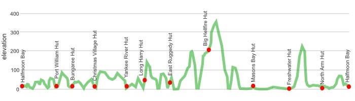
an anti-clockwise circuit from civilisation in Oban around the coast to Masons Bay then either cutting back inland towards Oban via Freshwater Landing.
In the longer days in summer it is possible to jump some huts but this becomes more difficult when the days shorten during winter.
click to view larger, more interactive topographic map from, err, topomap.co.nz
distance | North West Circuit- Rakiura National Park, Stewart Island
125 km – from/to Oban
time | North West Circuit – Rakiura National Park, Stewart Island
9 – 11 days including a rest day or trip up Mt Anglem
when | North West Circuit – Rakiura National Park, Stewart Island
Anytime?
Yes, the walk around the coast is at low level, obviously, the sea moderates the temperatures to a large degree so, believe it or not, it doesn’t really matter that much when you go despite being almost at 47º S. The rainfall is relatively consistent throughout the year, with perhaps surprisingly, July, August and September being the less wet months. But despite it raining on average every second day the total yearly rainfall in Oban, 930 mm, is less than that of Auckland or Wellington, so it rains often, but not for too long.
Daylight can be an issue: you get a whole lot in summer, no chance of Vitamin D deficiency then, it can be light enough to wander around at 10 pm, on 21 December sunrise is 5 50 am, sunset is 9 40 pm, a day length of almost 16 hours.
In winter on the shortest day, 21 June, the sun rises at 8 30 am and sets at 5 05 pm, a day length of only about 8.5 hours. That means you need an early start on the big days cranking the seven hours from East Ruggedy to Hellfire Pass, or the next day another seven hours from Hellfire to Mason Bay.
Moral of the story, you can basically go at any time of the year, just take your chances.
maps and GPS | North West Circuit – Rakiura National Park, Stewart Island
It’s sensible to have a paper map in case GPS batteries die.
Newtopo, newtopo.co.nz, produces the most useful map of the North West and Southern Circuits at a scale of 1:65,000 that is available for $20 from major DoC offices and some outdoor stores, Macpac keep them, or consult the list of retail outlets at newtopo.co.nz/where-to-buy.html.
Land Information New Zealand, LINZ, Topo50 maps, both digital and paper: CH08 Codfish Island (Whenuahou), CH09 Mount Anglem/Hananui, CJ08 Doughboy Bay, CJ09 Mount Allen, and maybe the little bit of Oban which is found on CJ10 Port Adventure.
Download free digital versions from LINZ Mapchooser, or buy the real thing, ie, on old fashioned paper, at DOC offices, outdoor shops and bookshops where maps sold. There’s a nationwide list at LINZ “Map Retailers”: https://www.linz.govt.nz/land/maps/search-map-retailers.
Need a custom map for your GPS device, download a more compact .klm format file from topomap.co.nz for free, although if you download a few maps consider a small donation, there’s considerable work gone into getting that info onto the internet and we should support these useful resources.
route description | North West Circuit – Rakiura National Park, Stewart Island
Anti-clockwise is the way to go, ie, Port William direction. The track then starts with a few easier stretches of track and builds to bigger days once the tide level on the food supplies has dropped, and you’ve become used to trudging for long periods of time through the mud.
huts | North West Circuit – Rakiura National Park, Stewart Island
Here’s the huts you will encounter in Rakiura National Park.
Camping really is only for the hardy due to the often soaked substrate and the extra bulk and weight of a tent on a 125 km wander is unnecessary when there will often be few others in the huts. If you want some adventure why not stay in the cave at the north end of West Ruggedy Beach instead.
You will also walk past some huts that are provided for hunters. Note that there is a separate booking system for these huts and hunters often fly in with their group.
And there’s always that cave, for the adventurous:
Tramping times | Northwest circuit – Rakiura National Park, Stewart Island
Here’s the DoC stated tramping times between huts, as shown on their website, usually actual walking times, ie, not taking into account any long breaks. DoC bases its estimation on times for an “average” tramper which means that it’s possible to slash times for more popular sections. With more remote sections on the west coast, the stated time is close to the actual time required.
Unfortunately, this time information tends to emphasise a pointless aspect of tramping, The Destination, and, some trampers feel they need to test themselves, rush, to prove something to someone. Aren’t you there to experience your environment, notice things, spot a kiwi, and watch the bellbirds flitting around? There’s no actual requirement to occupy the full ten hours a day racing through the landscape.
Halfmoon Bay to Port William Hut
Time: 4 hours
Distance: 12 km
Port William Hut to Bungaree Hut
Time: 3 – 4 hours
Distance: 6 km
Bungaree Hut to Christmas Village Hut
Time: 6 hours
Distance: 11.5 km
Side trip – Christmas Village Hut to Mt. Anglem/Hananui
Time: 6 hours return
Distance: 5.5 km
Christmas Village Hut to Yankee River Hut
Time: 6 hours
Distance: 12 km
Yankee River Hut to Long Harry Hut
Time: 5 hours
Distance: 8.5 km
Long Harry Hut to East Ruggedy Hut
Time: 5 – 6 hours
Distance: 9.5 km
East Ruggedy Hut to Hellfire Pass Hut
Time: 7 – 8 hours
Distance: 14 km
Hellfire Pass Hut to Mason Bay Hut
Time: 7 hours
Distance: 15 km
Mason Bay Hut to Freshwater Hut
Time: 3 hours
Distance: 15.5 km
Side trip – Rocky Mountain Track
Time: 3 hours return
Distance: 5 km
Freshwater Hut to North Arm Hut
Time: 6 – 7 hours
Distance: 11 km
North Arm Hut to Halfmoon Bay
Time: 4 hours
Distance: 12 km
getting there | North West Circuit – Rakiura National Park, Stewart Island
Here’s a suggestion: take the ferry across to build up the suspense, it’s a fun ride, and then fly back when you can identify where you have been from the air. And you then won’t have to worry about the 15 kg baggage limit.
Flying: Three flights a day, at slightly varying times depending on the season, 365 days a year, from Invercargill airport to the strip on Stewart Island/Rakiura. The flight takes 20 minutes and can give a good overview of the island. There’s a minibus to take passengers to/from the Oban Post Office which is included in the fare. Fares: adult return $220, one way $130, with a variety of others depending on passenger’s age. Baggage limit: 15 kg, now that’s a problem when you are heading to the island because you really need to travel with all your kilos of food. Phone Stewart Island Flights on 03 218 9129.
Ferry: The express catamaran ferry is now owned by Real Journeys which has connecting buses to Invercargill, Queenstown, and Te Anau. The trip takes about one hour from Bluff to Oban. There are daily ferries, with more than one on many days but it’s a mighty complicated schedule and fare structure, Adult: $85 (one-way) $148 (return, Child: $43 (one-way) $74 (return). There’s also a connecting bus from Invercargill with each ferry for an additional $26 each way.
supplies | North West Circuit – Rakiura National Park, Stewart Island
Invercargill, population 53,000, has the usual major supermarkets, Countdown, New World, Pak’nsave for getting the main supplies. Shellite or Fuelite for your stove can be obtained at outdoor and hardware stores if you haven’t been allowed to fly with it.
The small store, Ship to Shore Four Square supermarket, at Oban, population around 400, has a reasonable, if expensive, supply of food and basic camping needs, matches, candles, Fuelite, etc, and operates normal business hours, seven days a week.
warnings | North West Circuit – Rakiura National Park, Stewart Island
There is no ATM/money machine in Bluff, or on Rakiura, remember you are venturing to the edge of the Earth. Businesses to take cards, of course.
Heavy rain and strong winds can occur at any time of the year, which can have two effects. The track can be muddy in places and while the mud is legendary it is often not as bad as you might think, pack those gaiters and waterproof overtrousers.
The track can flood in places, more like a rising tide and having to wade through a shallow lake than a raging torrent. In any case, care should be taken and if in doubt spend an extra day in Masons Bay Hut until the flood recedes.
Getting from Mason Bay to Freshwater can involve long periods of wading through cool waters, trying not to fall off the duckboards you can’t quite make out in the gloomy water.
Care is needed at the north end of Masons Bay at high tide although a track has been cut around the problematic bluff.
other websites | North West Circuit – Rakiura National Park, Stewart Island
There are a few websites about tramping around Stewart Island/Rakiura.
The DOC North West Circuit site has fairly extensive information, including brief track notes from hut to hut.
a big image slideshow | North West Circuit – Rakiura National Park, Stewart Island
Images of the Stewart Island huts can be found in the Rakiura Hut section.
An additional 20 images can be found on the blog pages, one image a day.
Here’s a 43 image slideshow from the North West Circuit giving an indication of the general track conditions and sights along the way, if you need any further convincing.
Click on the thumbnail image below to get the slideshow started, then you can click on the left or right sides of the bigger images to go forward or back.
