Exhilaration plus!!
On a clear day you can see forever.
From Mt Fell or Mt Richmond you can take in the full north region of the South Island. Everything in Kahurangi National Park, from Mt Owen to Farewell Spit to the west. The Marlborough Sounds, Cook Strait, even Cape Palliser/Matakitakiakupe and the Aorangi Range on the southern tip of the North Island to the east. The Inland Kaikouras, including Tapuae-o-Uenuku, to the south. After rain with immensely clear skies Taranaki pops into view, around 230 km away.
Oh, it’s quite a grunt to get up there, at least from the Nelson side. But that is most of the reason you are going.
There are a few variations for your return but the views along the Mt Fell ridge above the treeline are well worth a second look, pointing the opposite direction.
where | Mt Richmond, Mt Richmond Forest Park
OK, you can drive your car halfway to the summit from the North Road on the Wairau side. This is not that walk. That’s not only cheating, it’s missing the most worthwhile aspect.
The real experience is walking from Nelson over to the Pelorus River valley, and every Nelsonian needs to experience that, and then the big days, both up and back, via Mt Fell.
click to view larger, more interactive topographic map from, err, topomap.co.nz
green—Brook St roadend to Mt Richmond via Roebuck and Mt Fell Huts
dark blue—Maitai Dam roadend to Dun Saddle
light blue—Middy Creek to Conical Knob
orange—Mt Richmond to Roebuck Hut via Grassy Knoll (off-track)
red—Richmond Saddle Hut to roadend
distance | Mt Richmond, Mt Richmond Forest Park
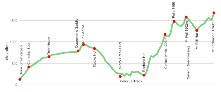
36.3 km from Brook Street in Nelson, to the summit of Mt Richmond, one way. It’s worth coming back the same way, or one of the variations.
time | Mt Richmond, Mt Richmond Forest Park
2.5 days, Brook Street, Nelson one way to Mt Richmond summit via Roebuck Hut. Same time on the way back.
when | Mt Richmond, Mt Richmond Forest Park
November to May is best. It’s a big day climbing from Middy Creek or Roebuck Huts to Mt Fell Hut, and daylight will be a factor in winter when days are shorter.
Winter also can have snow which slows travel times.
maps and GPS | Mt Richmond, Mt Richmond Forest Park
There is a Mt Richmond Forest Park map, Parkmap 274-06, which can be hard to find.
Most of the tracks appear on the Land Information New Zealand, LINZ, Topo50 series maps: Nelson, BQ 26 and Mt Patriarch, BR 26. Paper maps can be bought for $9 each at the DOC office at the Nelson iSite and some tramping supply shops: Hunting and Fishing is your best bet.
These maps can be downloaded at Nelson maps at LINZ and Kaikoura maps at LINZ. Then you can print your own sections as required. Or upload them to your phone.
Need a custom map for your GPS device, download a more compact .klm format file from topomap.co.nz for free, although if you download a few maps consider a small donation, there’s considerable work gone into getting that info onto the internet and we should support these useful resources.
route description | Mt Richmond, Mt Richmond Forest Park
The classic route to Mount Richmond is via the Dun Mountain Trail and Roebuck Hut.
Why?
Well, everyone should experience the upper Pelorus Valley and enjoy the immediate environs of Roebuck Hut. And Roebuck is off the beaten track now Middy Creek has become a stop on Te Araroa.
But there are other options. Up from the Maitai River dam roadend to Dun Saddle. Climbing from Middy Creek Hut to Conical Knob. Or, returning to Roebuck Hut completely off-track via the long ridge down from Grassy Knoll, (only for the truly adventurous).
The Dun Mountain Trail eases you into the walk, it’s a gradual incline on a historic tramway. Expect to see mountain bikers out and about. Pay attention if slogging up the considerably steeper track from the Maitai Dam, the bikes shoot semi-out-of-control down from Coppermine Saddle. The track from Rocks Hut down to the Pelorus is well beaten by the 1000 or so pairs of feet each year from the Te Araroa trekkers. The Pelorus Track to Roebuck undulates high above the river gorges and is much less trafficked. Plenty scenic if you appreciate ferns and forests.
From Roebuck to Conical Knob the old white Permolat markers are usually obvious and plentiful. Just one instruction, keep climbing. There is a breather halfway but it’s around 1000 m of climbing in a hurry. At Conical Knob the official track from Middy Creek has the standard orange isosceles triangular DOC markers in the forest. Once above the tree line snow poles appear at regular intervals, useful if you are in the clouds. These are standard steel Waratah posts topped with orange plastic electrical conduit.
It’s a long haul along the ridge from Conical Knob towards Mt Richmond, with two gnarly climbs, up Point 1496, where there is The Chain for assistance, (if you need reassurance about the nearby drop-off), and a scramble up Mount Fell that will also make you feel like you are undertaking an adventure. The climb to Mount Richmond itself, and descent to Richmond Saddle Hut is straight forward rock hopping.
Roebuck, or Middy to Richmond Saddle involves around 2500 m climbing, so most will appreciate staying at the pleasant Mount Fell Hut where you only have the 1800 m under your belt for the day.
See the slideshow at the bottom of this page if you require further convincing.
huts | Mt Richmond, Mt Richmond Forest Park
Mt Richmond Forest Park has many huts. Middy Creek and Rocks Huts are on Te Araroa and get busy in summer. Richmond Saddle is a popular weekend trip from those from the Blenheim side.
tramping times | Mt Richmond, Mt Richmond Forest Park
Here’s the DOC stated tramping times between huts, as shown on their signage, usually actual walking times, ie, not taking into account any long breaks. DOC bases its estimation on times for an “average” tramper which means that it’s possible to walk faster.
Either, via Dun Mountain Trail
Brook Street road end to Rocks Hut
Time: 4.5—5 hours
Or, from the Maitai Dam
Maitai Dam road end to Rocks Hut
Time: 4.5—5 hours
Rocks Hut to Roebuck Hut
Time: 6 hours
Roebuck or Middy Creek Hut to Mt Fell Hut
Time: 8—9 hours
Mt Fell Hut to Richmond Saddle Hut
Time: 4 hours
Richmond Saddle Hut to Roebuck Hut via Grassy Knoll Note this is off-track, ie, no track markers.
Time: 5—6 hours
Richmond Saddle Hut to roadend
Time: 4 hours
getting there | Mt Richmond, Mt Richmond Forest Park
No public transport available. But you can walk to the start of the Dun Mountain Trail from your accommodation in Nelson. Or grab a taxi.
Note that it is quicker, but steeper, to take a short cut that starts near the entrance to the Brook Street campground/Waimarama Sanctuary than the official start to the Dun Mountain Trail. Start at the large green sign that says “Brook Conservation Reserve—Coppermine Saddle 4 hours” that is opposite the last of the houses. The route via Tantragee Saddle winds around excessively and is well populated by mountain bikers doing their crazy thing.
supplies | Mt Richmond, Mt Richmond Forest Park
Nelson has three major supermarkets: Countdown x 2, open 7am to 10pm; New World, open 7am to 10 30 pm; Freshchoice, open 7 am to 9 pm, all seven days.
There are many shops in Nelson selling Shellite/Fuelite, and gas canisters for your stove: Rollos, Hunting and Fishing, Kathmandu and Macpac. There is also a big Mitre 10 which might be the cheapest option, but that is closer to the airport than in town .
warnings | Mt Richmond, Mt Richmond Forest Park
Getting to Roebuck Hut or Middy Creek is easy enough, it’s a well worn track. But the climb up Mount Fell involves 1800 m climbing and takes about eight or nine hours of relentless climbing. Leave early.
As well as the continual grind there are two steep and somewhat gnarly stretches. First, the climb up to Point 1496 involves sidling above a massive, ie, more than 50 m drop, and then scrambling up a steep slope. You will be assisted by The Chain, a galvanised steel link chain that is bolted to the rock. Probably worse coming down. Useful to have a head for heights, although there is little actual danger.
The scramble up to the summit of Mount Fell it is also steep, as in seriously steep.
The snow grass can be exceedingly slippery when wet, or covered in snow.
The main ridge, once out of the forest, is entirely exposed to the weather, and it can really blow up there. And rain.
The Mt Fell Hut has been recently located about 400 m south along the track, and is now open.
Note the lack of daylight hours in winter.
Richmond Saddle Hut to Middy Creek Hut is a huge enough day in the downwards direction. You would need to be fit, leave early, and move quickly to make it uphill in a day. And that climbing is unrelenting.
The track up to Conical Knob from Roebuck Hut starts with a sign to say that “maintenance on this track was discontinued in 1994”. Despite this it is well marked with old style white Permolat markers at regular intervals, short pieces of Venetian blinds, and once up on the main ridge it is pretty straightforward to follow. There is one bluff just below Conical Knob where a short sidle as required, but this is reasonably well marked, as long as you keep your eyes open for the markers.
In the downwards direction from Conical Knob the initial route down towards Roebuck Hut has few markers, guess DOC doesn’t want to advertise the route, but they start to become more regular after about 100 m. Note that you have to make a left turn before the ridge turns into a bluff. This is also reasonably well marked.
An alternative, considerably more adventurous, but ultimately quicker return follows the long ridge from Grassy Knoll down to Roebuck Hut. A fun day out, but has a few perils. Getting around to the ridge involves a steep sidle under Grassy Knoll with a few steep and slippery stream crossings. It’s the short stretches of steepness, not the wetness that is the issue. It is then straightforward on the unmarked ridge for a few kilometres until getting into some tough windfall patches. Stay on the west side of the ridge to avoid the worst of them. There is also a short section of river travel which involves several crossings of the upper Pelorus and tributaries which would be impassable after rain, and some gorgey climb arounds. That’s all part of the Little Adventure. Another super challenging day out, even if half the distance is easy.
Some blogs | Mt Richmond, Mt Richmond Forest Park
Here’s a couple of blogs about getting up and back:
Up via Roebuck, back via Middy Creek
Up via Middy Creek, back cross country via Grassy Knoll and Roebuck
other websites | Mt Richmond, Mt Richmond Forest Park
If you pike out and go from the Wairau Valley, DOC has the https://www.doc.govt.nz/parks-and-recreation/places-to-go/marlborough/places/mount-richmond-forest-park/things-to-do/tracks/mt-richmond-routes/
a big image slideshow | Mt Richmond, Mt Richmond Forest Park
Here’s a 37 image slideshow from the Mt Richmond route, giving an indication of the general track conditions and sights along the way, if you need any further convincing.
Click on the thumbnail image below to get the slideshow started, then you can click on the left or right sides of the bigger images to go forward or back.

Images of the Mt Richmond route huts can be found in the Mt Richmond huts section.