A permanent legacy of the creation of a few recreational tracks in the late 1970s. The St James Walkway is another.
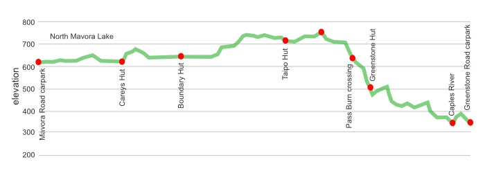
Glancing at a map makes it look easy enough. You start by walking around a lake, the North Mavora Lake, then follow up a broad easy valley to a low, almost imperceptible, saddle, drop down onto the well-manicured Greenstone Track and finish at another big lake, Lake Wakatipu.
Nothing to it really.
The reality is a little different, a good portion of the route is in Tussockland with no definitive trail to follow, just wander between the tussock clumps with an eye to the next orange marker on a post. And it has a tendency to be swampy in places, you are likely to end up with wet feet.
All in all the views are rated Splendid, without getting into the Totally Humungously Spectacular.
A good trail for beginners, or families, who want a safe and not fully strenuous introduction to tramping in the South Island.
where | Mavora Greenstone Walkway, Mavora Lakes Conservation Park
Greenstone Station Road carpark, near Lake Wakatipu to the Mavora Lakes Road carpark at the south end of the North Mavora Lake.
click to view larger, more interactive topographic map from, err, topomap.co.nz
distance | Mavora Greenstone Walkway, Mavora Lakes Conservation Park
50 km one way
time | Mavora Greenstone Walkway, Mavora Lakes Conservation Park
3 – 4 days, depending on your enthusiasm for walking
when | Mavora Greenstone Walkway, Mavora Lakes Conservation Park
Avoid snow, ie, go in the summerish months, November to May. The water is turned off at the huts over winter to avoid freezing, but can be drawn from the nearby river or lake. Two huts don’t have heating.
maps and GPS | Mavora Greenstone Walkway, Mavora Lakes Conservation Park
Download free digital versions from LINZ Mapchooser, or buy the real thing, ie, on old fashioned paper, at DOC offices, outdoor shops and bookshops where maps sold. There’s a nationwide list at LINZ Map Retailers.
The main map you need is Topo50 CC09 North Mavora Lake, covering Greenstone Hut to the southern end of North Mavora Lake, with some of the trail is on CB10 Glenorchy and a few 100ms on CB09 Hollyford.
Need a custom map for your GPS device, download a more compact .klm format file from topomap.co.nz for free, although if you download a few maps consider a small donation, there’s considerable work gone into getting that info onto the internet and we should support these useful resources.
There’s a detailed map on the wall at each of the huts where you can take a photo.
route description | Mavora Greenstone Walkway
The northern end starts at the Greenstone Road carpark, heads over the first section of the Greenstone Track, until the Greenstone Hut, then branching off and up to a saddle, from where it is often downhill to the end of the North Mavora Lake.
Either direction is fine, although if the weather is not so good heading south will mean you have somewhere to stay, ie, Greenstone Hut, if Pass Burn is, umm, impassible.
huts and camping | Mavora Greenstone Walkway, Mavora Lakes Conservation Park
There are 3 DOC huts that each cost $10 per person a night. You can camp outside these huts for a big nuttin’, ie, free.
There is one serviced hut which is $15 each a night. It costs $5 to camp outside.
There’s also a shelter at the Greenstone Road carpark that’s only suitable for the desperate.
The official campsite at the North Mavora Lake is reasonable, $6 an adult, but you may share with a fair contingent of the motorised brigade, campervans, caravans, boats, horses, buses, etc.
tramping times | Mavora Greenstone Walkway, Mavora Lakes Conservation Park
Here’s the DOC stated tramping times between huts, as shown on their website, usually actual walking times, ie, not taking into account any long breaks. DOC bases its estimation on times for an “average” tramper which means that it’s possible to walk faster.
Unfortunately, this time information tends to emphasise a pointless aspect of tramping, The Destination, and, some trampers feel they need to test themselves, rush, to prove something to someone. Aren’t you there to experience your environment, notice things, experience the views, watch the bellbirds flitting around? There’s no actual requirement to minimise the time racing through this memorable landscape.
North Mavora Lake carpark to Careys Hut
Time: 2 hours (2.5 — 3 seems more likely)
Distance: 10 km
Careys Hut to Boundary Hut
Time: 2 hours
Distance: 6 km
Boundary Hut to Taipo Hut
Time: 3 – 4 hours
Distance: 12 km
Taipo Hut to Greenstone Hut
Time: 4 – 5 hours
Distance: 10 km
Greenstone Hut to Greenstone Road carpark
Time: 3 – 5 hours
Distance: 11 km
getting there | Mavora Greenstone Walkway
Not so easy this one.
Buckley Transport provides a service to the Greenstone shelter and carpark, past Kinloch, leaving Queenstown at 8 am, arriving 10 am. Departs Greenstone shelter at 12 noon for return to Queenstown. Cost: Queenstown, $52 adult, $35 child. Glenorchy, $36 adult, $20 child.
Other than that you are on your own.
The Mavora Lake campsite is fairly popular over the summer months, you may find 30 camping parties and there is a surprising amount of traffic on the Mavora Lake Road. Hitching is a real possibility although entirely unreliable.
supplies | Mavora Greenstone Walkway, Mavora Lakes Conservation Park
Queenstown has the usual major supermarket, New World, but it is located in Frankton just past the airport, 7 km from downtown Queenstown. There’s a bus out there. The Fresh Choice that is a kilometre from the centre is big enough to stock most items you would need at a significantly more competitive price than the Alpine Store right in town.
Shellite or Fuelite for your stove can be obtained at outdoor and hardware stores if you haven’t been allowed to fly with it.
Te Anau has one major supermarket, Freshchoice, open 7 am to 9 pm seven days, for getting the main supplies. There is also a small 4 Square with similar, but marginally truncated opening hours.
Shellite or Fuelite and gas canisters for your stove can be obtained at Outdoor Sports, Fiordland Frontier Supplies, both open Monday – Friday 9 00 am – 5 30 pm and Saturday 9 am-1 pm, or Mitre 10, Monday – Friday 8 am – 5 30 pm, Saturday 9 am-4 pm, Sunday 11 am-3 pm, if you haven’t been allowed to fly with it. All these shops are in the main shopping area of Te Anau.
warnings | Mavora Greenstone Walkway, Mavora Lakes Conservation Park
This is a relatively safe trip: no avalanche danger, there’s a couple of swing bridges in place to cross the Mararoa River. There is, however, one gnarly creek crossing, Pass Burn, not so far from Greenstone Hut that does not have any all-weather means of crossing. You may have to simply wait until the water level drops, which, due the terrain’s steepness would not be long after the rain’s cessation.
Two of the three huts have no heating as they are out in Tussockland. No surprise they can be cold.
Overall, walking or down the long valley can be fairly damp underfoot, there’s areas of sogginess through the tussock. Expect to get your feet wet.
Access is somewhat of an issue, the south end of the walkway is 38 km from state highway, too, the north end is the green stone track rodeo, also fair way away from anywhere.
other websites | Mavora Greenstone Walkway
The official Mavora Greenstone Walkway website.
There’s also a Mavora Greenstone Walkway brochure to download.
a big image slideshow | Mavora Greenstone Walkway, Mavora Lakes Conservation Park
Here’s a 30 image slideshow from the Mavora Greenstone Walkway giving an indication of the general track conditions and sights along the way, if you need any further convincing.
Click on the thumbnail image below to get the slideshow started, then you can click on the left or right sides of the bigger images to go forward or back.
