A more energetic variation of the Abel Tasman experience, less congestion, slightly more adventure than the Coastal Track has to offer.
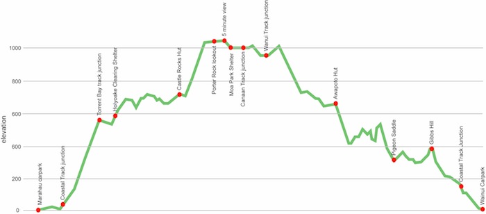
A big climb, mostly on a benched track, to Holyoake Clearing from Marahau, or Awapoto Hut from the north, you eventually oscillate along around the 1000 m mark. Highlights include some huge views at Castle Rock, Porters Rock, over to Nelson, Mount Richmond and the inland Kaikouras, and in the north Gibbs Hill, looking down at Farewell Spit and over to Kahurangi National Park.
The track is mostly in forest, in the south up through regenerating manuka scrub following early land clearing, as you trudge higher beech trees appear, with scattering of rimu, miro and various broadleafs, a few patches of NZ cedars at higher level and then even a rare nikau palm at mid-range, ie, it’s varied and interesting, with the bonus of whacky, Dr Seuss like, dracophyllums and mountain cabbage trees.
It’s quite a different walk from the busy and very social highway of the Coastal Track. It’s certainly more physically challenging, maybe that’s why you might often have the huts to yourself, even in peak season. And those cosy huts are only $5 a night, not the $32 down where the crowds are massing.
Worth a look.
where | Inland Track, Abel Tasman National Park
The Abel Tasman Inland Track goes, err, through the heart of the Abel Tasman National Park, starting in Marahau about 65 km by road west of Nelson.
It’s common to start at the Marahau end and walk north to do the more severe climbing on a benched track, ie, slow and steady climbing, but others may do it from the north as a return from the Coastal Track, swinging from the shrubbery needed this direction, or dropping down from Canaan.
click to view larger, more interactive topographic map from, err, topomap.co.nz
distance | Inland Track, Abel Tasman National Park
41 km Marahau carpark to Wainui carpark
time | Inland Track, Abel Tasman National Park
2 nights, ie, 3 days is common, although you could do it a day quicker if super enthusiastic.
when | Inland Track, Abel Tasman National Park
Anytime, the weather is relatively benign and there’s no major rivers or mountain passes.
maps and GPS | Inland Track, Abel Tasman National Park
The track is extensively marked with decent signage, you are unlikely to get lost, at least if you know where you want to go.
If you need a free alternative in the map department you can take a digital photo of the topographical maps that are on display at each roadend, and look at your camera when you need clarification to your, or your next destination’s, whereabouts. They have a high enough level of detail.
If that’s not enough, and it probably is, there’s a few options.
Download free digital versions from LINZ Mapchooser, then you can print off the areas you need yourself.
Or it’s possible to buy the real thing, ie, on old fashioned paper, there’s a couple of detailed options there.
Newtopo produces the most useful dead tree map of the Abel Tasman Coastal Track and Inland Track from newtopo.co.nz/abel-tasman-map.html at a scale of 1:55,000, available for $11 from major DoC offices and some outdoor stores, Macpac keep them, or consult this list of retail outlets at newtopo.co.nz/where-to-buy.html.
There’s also the Topo50 series maps that cover the country, for Abel Tasman you need two, BN25 Totaranui and BP25 Motueka, each costing around $7.90 and available at DOC offices, outdoor shops and bookshops where maps sold. There’s a nationwide list at LINZ Map Retailers.
Need a custom map for your GPS device, download a more compact .klm format file from topomap.co.nz for free, although if you download a few maps consider a small donation, there’s considerable work gone into getting that info onto the internet and we should support these useful resources.
route description | Inland Track, Abel Tasman National Park
Whether you go south to north, or north to south, is not a major issue. Starting in Marahau gets you through the more populated parts of the park early on and leaves the less frequented, and many think the more attractive, area north of Totaranui to the end.
huts and campsites | Inland Track, Abel Tasman National Park
Here’s the two huts you may encounter on the Inland Track in Abel Tasman National Park:
There’s two shelters of varying degrees of amenity, Holyoake, great but tiny, and Moa, not much.
You can camp outside any of the huts or shelters.
You can also stay at Whariwharangi Bay Hut but you need to book and it costs $32.
Tramping times | Inland Track, Abel Tasman National Park
Here’s the DoC stated tramping times between huts, as shown on their website, usually actual walking times, ie, not taking into account any long breaks. DoC bases its estimation on times for an “average” tramper which means that it’s possible to slash times for more popular sections. With more remote sections the stated time is close to the actual time required.
Unfortunately, this time information tends to emphasise a pointless aspect of tramping, The Destination, and, some trampers feel they need to test themselves, rush, to prove something to someone. Aren’t you there to experience your environment, notice things, go down to the river and spot a huge trout, and watch the bellbirds flitting around? There’s no actual requirement to occupy the full 10 hours a day racing through the landscape.
Marahau to Castle Rocks Hut
Time: 5 hours 30 minutes
Distance: 15.1 km
Castle Rocks Hut to Awapoto Hut
Time: 6 hours
Distance: 13 km
Awapoto Hut to Pigeon Saddle
Time: 3 hours
Distance: 5 km
Pigeon Saddle to Wainui carpark
Time: 2 hours 25 minutes
Distance: 8 km
getting there | Inland Track, Abel Tasman National Park
There are scheduled trips from Nelson to Marahau car park via Richmond and Motueka, and also from Wainui to Nelson or Marahau. Unfortunately, the regularity of the various companies and routes has not yet settled back to what was once available pre-Covid in early 2020 when four companies did the routes. Hopefully we will return to plenty of choice soon.
Golden Bay Coachlines routes and timetables are still in flux due to Covid disruption.
Trek Express also offers various services. Nelson to Marahau is $35, and Nelson to Wainui is $65. They can also do special trips for a minimum group of four.
Getting around by hitching is also possible but, of course, entirely unreliable.
supplies | Inland Track, Abel Tasman National Park
Nelson, Richmond, and Motueka have the usual major supermarkets, Countdown, New World, Pak’nsave for getting the main supplies. Shellite or Fuelite and gas canisters for your stove can also be obtained at outdoor and hardware stores, if you haven’t been allowed to fly with it.
Takaka has a big FreshChoice, owned by Woolworths, with just about anything you could need in terms of food.
Elsewhere? Not much in the food/fuel range, ie, get everything you need before setting out.
warnings | Inland Track, Abel Tasman National Park
This is a different type of track than the made for geriatric Coastal Track, ie, it’s very much more like the remainder of the tramps in the South Island, it can be steep, the hills go on for hours, there are tree roots, etc, you expend energy. Just saying.
blogs | Inland Track, Abel Tasman National Park
I haven’t found many engaging blogs about this particular route, but my own blog starts here: Abel Tasman Inland Route blog.
“Sandflies: none.
The track: very dry, ie, almost perfect.
The weather: perfect.
The company: also perfect, ie, no one else around. They are all flocking on the Coastal Track. Not many go Inland, getting that aerial perspective.”