If you want to ease your way into a West Coast tramping experience this is a great way to start.
A couple of biggish climbs, to tease your sense of adventure, snow poles where it matters, an adequate sprinkling of huts, there’s a choice of eight, and a busy highway at both ends for ready access.
This is as close as it gets to a circuit in Arthurs Pass National Park.
The highlights:
standing on the edge of remoteness at the top of Harman Pass and looking over to Whitehorse Pass where you could drop into the top of the Wilberforce River,
immersion in the hot springs at Julia Hut,
the minor adventure of finding your own path down much of the Taipo River valley,
spotting blue ducks doing their ducky thing in the rapids and their bizarre hopping from rock to slippery rock,
travel over the alpine grasslands with a decent view of the Tasman, on a clear day.
So, there’s plenty of interest.
And a likelihood of not too much company. In any case, the huts are a reasonable size.
And it’s a reasonable physical workout.
where | Harman Pass, Arthurs Pass National Park
From Kellys Creek in the Otira River valley, not so far downstream from Otira, up over the Kelly Range to the Taipo River valley, blatting up to Harman Pass, then steeply down the Taipoiti River to White River, a major tributory of the Waimakiriri River, then out to Bealey Bridge on Highway 73.
Of course, you can always go the other direction.
click to view larger, more interactive topographic map from, err, topomap.co.nz
distance | Harman Pass, Arthurs Pass National Park
50 km one way
time | Harman Pass, Arthurs Pass National Park
3 – 4 days, depending on your enthusiasm for walking
when | Harman Pass, Arthurs Pass National Park
December to May, due to the avalanche danger and potentially icy conditions in Taipoiti River over winter and spring.
Check with DOC in Arthurs Pass whether the route is considered safe.
maps and GPS | Harman Pass, Arthurs Pass National Park
If you need to buy a real map, ie, on old fashioned paper, the Newtopo Arthurs Pass map www.newtopo.co.nz/arthurs-pass-map.html at a scale of 1:55,000, $20, is available from major DOC offices and some outdoor stores, Macpac keep them, or consult the website for a comprehensive list of retail outlets. That has the route on one map which also covers the whole of the Arthurs Pass National Park.
Or, there are the Land Information New Zealand, LINZ, Topo50 maps, both digital and paper: Topo50 map BV20 – Otira.
Download free digital versions from LINZ Mapchooser, or buy the real thing, ie, on old fashioned paper, at DOC offices, outdoor shops and bookshops where maps sold. There’s a nationwide list at LINZ Map Retailers.
Need a custom map for your GPS device, download a more compact .klm format file from topomap.co.nz for free, although if you download a few maps consider a small donation, there’s considerable work gone into getting that info onto the internet and we should support these useful resources.
route description | Harman Pass, Arthurs Pass National Park
This tramp can be done equally well from either direction although it is probably easier to descend the loose and lumpy scree on the Waimak side of Harman Pass than try to struggle up it.
From Kellys Creek you get the climbing over with quickly, ie, it’s relatively steep up to Carroll Hut, then you lose altitude on the western side almost as quickly.
From Dillon Hut it’s a long walk up the Taipo Valley to Julia Hut, crossing the river above the cableway is probably quicker if the water level allows. From Julia Hut there is a considerable number of crossings of Mary Creek, lots of boulder hopping, to get to Harman Pass. Look out for the snow poles where you leave the creek before the gorge on the true left of the creek.
Taipoiti River is not easy to traverse even when water levels are low, a very moveable substrate, and is completely avalanche prone during the winter and spring months. There is another cableway near the junction with the White River for when the river is up.
From Carrington it is easier walking in the broad Waimakariri River valley, just a few streams to get across Harp, Greenlaw Creeks, then the Anti Crow River and Jordan Stream before getting out to Bealey Bridge and SH 73.
huts and campsites | Harman Pass, Arthurs Pass National Park
The Arthurs Pass National Park huts are of varying ages and comfortable enough, the mattresses are okay, the fireboxes or fires work if there is dry wood, (Carroll Hut is unheated), the roof keeps the water out, what’s to complain about?
As this is a relatively under populated circuit you can probably get away without having a tent unless you choose peak tramping season.
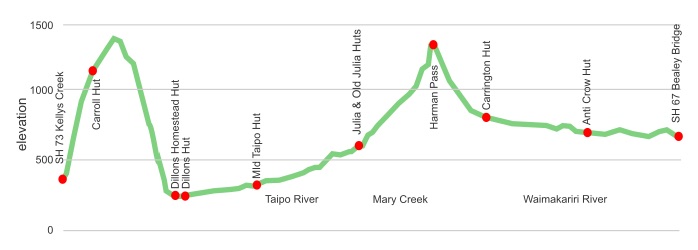
Here’s the huts you will encounter:
Tramping times | Harman Pass, Arthurs Pass National Park
Here’s the DOC stated tramping times between huts, as shown on their website, usually actual walking times, ie, not taking into account any long breaks. DOC bases its estimation on times for an “average” tramper which means that it’s possible to slash times for more popular sections. With more remote sections the stated time is close to the actual time required.
Unfortunately this time information tends to emphasise a pointless aspect of tramping, The Destination, and, some trampers feel they need to test themselves, rush, to prove something to someone. Aren’t you there to experience your environment, notice things, go down to the river and spot a blue duck or two, watch the bellbirds flitting around? There’s no actual requirement to occupy the full 10 hours a day racing through the landscape.
SH 73 at Kellys Creek to Carroll Hut
Time: 3 hours up, 1.5 hours down (she’s pretty steep)
Carroll Hut to Dillons Hut
Time: 4 hours up, 3 hours down
Dillons Hut to Mid Taipo Hut
Time: 4.5 hours
Mid Taipo Hut to Julia Hut
Time: 4.5 hours
Julia Hut to Harman Pass
Time: 4.5 hours
Harman Pass to Carrington Hut
Time: 3 hours
Carrington Hut to Anti Crow Hut
Time: 2-3 hours
Anti Crow Hut to SH 73 at Waimak Bridge
Time: 2-3 hours
getting there | Harman Pass, Arthurs Pass National Park
From Greymouth you can jump on the “West Coast Shuttle“https://www.eastwestcoaches.co.nz/greymouth-to-christchurch-shuttle.html bus departing outside the Greymouth railway station, at 8 15 am and arriving at Aitkens around 9 10 am or thereabouts, or, departing Christchurch at 2 00 pm and arriving at Aitkens around 4 20 pm, ie, giving limited time to get to the first hut. Phone 03 768 0028, or 027 492 7000, or email travel@westcoastshuttle.co.nz for further information and pricing.
Getting around by hitching is also possible but, of course, entirely unreliable.
supplies | Harman Pass, Arthurs Pass National Park
Christchurch has the works of course — the usual major supermarkets, Countdown, New World, Pak’n’save for getting the main supplies. Shellite or Fuelite and gas canisters for your stove can be obtained at outdoor and hardware stores, if you haven’t been allowed to fly with it.
On the West Coast side Hokitika has a New World, open 8 00 am to 8 00 pm seven days, and Greymouth both a New World, 7 00 am to 9 00 pm, and a more central Countdown, also 7 00 am to 9 00 pm seven days a week.
Arthurs Pass has a small and expensive shop that caters mostly to the passing tourist trade.
warnings | Harman Pass, Arthurs Pass National Park
Ice, avalanches, gnarly river crossings, foggy tops. Harman Pass is not a trip for anyone with limited tramping experience, or inadequate equipment.
The climb/descent from Harman Pass towards the Waimak River is over loose rocks, many biggish, most mobile. Snow/ice is likely to last in the Taipoiti River until summer due to extensive shading from Mt Campbell to the north. There’s massive avalanche risk in the Taipoiti River for as long as the snow lasts, ie, December. Check with the DOC office at Arthurs Pass as to whether the snow has gone.
Like all West Coast rivers, the Taipo can become impassable in a big hurry. While there are three swing bridges and the cableway to cross the Taipo, some tributary crossings, and all Mary Creek crossings would be, err, impassable after rain. The streams on the Waimak side, ie, Greenlaw, Jordan, etc, can also rise rapidly.
There’s not much track up the Taipo, at least on the grassy river flats, you make your own way. But in the forest sections, there are the usual DOC orange triangles, also when required to leave the riverbed there are adequate snow poles to indicate the route.
The track on the tops around Carroll Hut can be difficult to follow if there is foggy weather, and fog happens a lot up there.
Yeah, it’s actually a fairly demanding route, so reasonable fitness and experience in off-track conditions would help enjoyment levels.
other websites | Harman Pass, Arthurs Pass National Park
DOC’s take on the route is here
DOC have a downloadable Harman Pass Route Guide
a big image slideshow | Harman Pass, Arthurs Pass National Park
Here’s a 34 image slideshow from Harman Pass giving an indication of the general track conditions and sights along the way, if you need any further convincing.
Click on the thumbnail image below to get the slideshow started, then you can click on the left or right sides of the bigger images to go forward or back.
For some reason they are somewhat out of order, I’ll try to get ‘em sorted soonish.

Images of the Harman Pass huts can be found in the Arthurs Pass huts and campsites section.