Hours of tramping over head and cannonball-sized and shaped boulders on a steeply sloping shoreline.
Big river crossings: Cascade, the biggest, Hope, Spoon, Gorge, Hacket. Plenty of creeks as well: Callery, Ryans, McKenzie, and a bunch of unnamed ones. Any may be impassable when flooding.
A climb over a poorly marked track at Sandrock Bluff. An unnamed bluff to get around at high tide on each side of Gorge River.
Oh, and sandflies.
On the other hand, it’s great to adventure your way along the coast, camping as required.
Two beachside huts for recuperation, or shelter, at Gorge River and Big Bay.
Here’s the thing. It’s remote.
Far from roads. People. Civilisation.
Clearly something special about wandering along the coastline with occasional penguins, seals, and seabirds to be seen.
There is a story here. In 1973 two big bulldozers, and two tractors created a track from the Ahuriri River bridge over to the coast at Barn Bay, and then south along the shore, partly below the high tide mark as far as Big Bay, before heading into the Pyke River. The intention was to make it as far as the Red Hills to do some mining for asbestos up at 1500 m, but the Canadian mining company decided after four months of dozer work that maybe it was too rugged, abandoned their plans, and the crew took another two months to return.
The Gorge River DOC hut is a legacy of that venture.
Parts of that bulldozed track are usable, ie, from the Cascade River down to Barn Bay, occasionally through the boulder field, and particularly over Sandrock Bluff.
Yeah, this is an adventure that few experience, in fact, fewer than 50 trampers went through in 2018.
Just check the long-term weather forecast, and tide times, and pay particular attention to the warnings further down this page.
Only for those with good balance for the rock hopping, and the stamina to keep powering through the sloping rounded gravel beaches.
You know you need a challenge.
where | Cascade River to Martins Bay coast route, South Westland
This route links the most southern road on the West Coast, around 60 km south of Haast, to the coastal end of the Hollyford Track at Martins Bay.
(It is possible to walk directly from Jackson Bay via Stafford Bay and the Cascade Plateau, via Whiskey Creek, but that is very much more demanding, and you need to swim the Cascade River at the mouth at low tide. Can, and has been done, by the resolute. That northernmost section is beyond the scope of this webpage.)
click to view larger, more interactive topographic map from, err, topomap.co.nz
distance | Cascade River to Martins Bay coast route, South Westland
77 km, Jackson River Road roadend carpark to Martins Bay Hut.
From there it’s another 56 km to the end of the Hollyford Track. Either tramp, fly or jet boat out from there. It’s also possible to go directly from Big Bay Hut to Alabaster Hut via the Pyke River route, although this is very weather dependent, due to the unbridged river crossings. The Pyke has two big days, and some serious wet underfoot conditions.
time | Cascade River to Martins Bay coast route, South Westland
4 huge days minimum. More sensible to have 6 or more, to include a muck around day at Gorge River. You then need to get out to civilisation either via the Hollyford Track or Pyke.
when | Cascade River to Martins Bay coast route, South Westland
Yup, anytime.
No problem with snow or avalanches on this route, being at sea level. It’s possible to tramp at any time of the year, although if you want to hurry through you will appreciate longer daylight hours.
More important to ensure you are going to have clear weather, as any of the unbridged rivers can create a major obstacle. And it may not be pleasant waiting for the rivers to drop.
maps and GPS | Cascade River to Martins Bay coast route, South Westland
No major issues with the route following here, you follow the coast, right? Still worthwhile having some maps, however.
Land Information New Zealand, LINZ, Topo50 maps, both digital and paper: BZ10 Cascade Plateau, BZ09 Awarua Point, give most of the route, but CA09 Alabaster Pass is useful to include the Hollyford/Pyke Tracks.
Download free digital versions from LINZ Mapchooser Martins Bay, or buy the real thing, ie, on old-fashioned paper, at DOC offices, outdoor shops and bookshops where maps sold. There’s a nationwide list at LINZ Map Retailers.
Need a custom map for your GPS device, download a more compact .klm format file from topomap.co.nz for free, although if you download a few maps consider a small donation, there’s considerable work gone into getting that info onto the internet and we should support these useful resources.
route description | Cascade River to Martins Bay coast route, South Westland
Probably best to go from north to south as the Jackson River Road roadend is more difficult to access due to its remoteness. The walking also gets progressively easier, mostly, with the boulders becoming gravel and sand at times as you go south.
Hopefully, you can get dropped off at the Jackson River Road roadend gate. You need a map to negotiate to the track on the other side of the Cascade River. There’s also a turn just before you get to the farm outbuildings before Dee Creek to find the continuation of the track. At Hope River, the route down to the actual river has been washed out and you need to cross the Hope a few times before you get to the coast.
Following the coast down is fairly obvious. The track climbs over Sandrock Bluff, and is somewhat hard to follow, particularly on the south side. The base of the track is well enough marked and is about 1 km from the other side of the bluff. (If you come from the south you need to go 100 m or so up Bluff Creek, and look out for the fishing buoys.)
Just note that there are few camping spots along the way. And that it may take longer than you think.
From Big Bay Hut you can continue around the coast to Martins Bay Hut and either tramp out via the Demon Trail, jet boat up Lake McKerrow/Whakatipu Waitai, or fly. Or, if the weather forecast is still good, have two big, wet days on the Pyke.
At the south end of the Hollyford Track, 17 km from the Milford road, there is a carpark and usually plenty of traffic due to the nearby 275 m Humboldt Falls. Quite possible to hitchhike to Te Anau.
huts and campsites | Cascade River to Martins Bay coast route, South Westland
There are three huts along the track, the Hope River private hut, Spoon Hut, Gorge River Hut, and Big Bay Hut. A few unofficial campsites along the coast as shown below. It’s surprisingly difficult to find other spots adjacent to water that have a flat, dry, place big enough to whack up a tent.
Barn Bay/Hope River private hut
Spoon River campsite Note that a 4 bunk hunters hut has been recently moved here from a location a few hours upstream. “Spoon Hut”: https://www.doc.govt.nz/parks-and-recreation/places-to-go/west-coast/places/jackson-bay-gorge-river-area/things-to-do/huts/spoon-hut/ is on the north side of Spoon River.
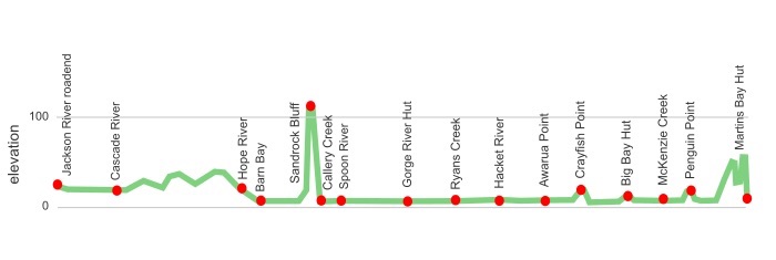
tramping times | Cascade River to Martins Bay coast route, South Westland
DOC does not have official tramping times between these points.
Here is a reasonable approximation for your average fit tramper for planning purposes. You might be able to knock some time off if you have experience rock hopping, and aren’t carrying much.
Jackson River Road carpark to Barn Bay private hut
Time: 7 hours
Distance: 19 km
Barn Bay private hut to Spoon Hut
Time: 6 hours
Distance: 11 km
Spoon Hut to Gorge River Hut
Time: 3 hours
Distance: 7 km
Gorge River Hut to Ryans Creek
Time: 2 hours 30 minutes
Distance: 6 km
Ryans Creek to Hacket Creek
Time: 1 hour 30 minutes
Distance: 5 km
Hacket Creek to Awarua Point
Time: 2 hours
Distance: 4 km
Awarua Point to Big Bay Hut
Time: 3 hours
Distance: 8 km
Big Bay Hut to Martins Bay Hut
Time: 4 — 5 hours (DOC time)
Distance: 16 km
getting there | Cascade River to Martins Bay coast route, South Westland
The Intercity bus can drop you off near the DOC office intersection at Haast, but that is about 50 km from the end of the road. Always possible to try your luck hitchhiking.
The best bet is to get dropped off by a friend at the roadend south of Haast. There is a lot more traffic when exiting via the Hollyford Track.
supplies | Cascade River to Martins Bay coast route, South Westland
Te Anau has a large Freshchoice, open 7 days, 8 am — 9 pm.
Haast Beach has a small General Store with some groceries, open 7 days, 9 am — 6 pm.
warnings | Cascade River to Martins Bay coast route, South Westland
Big rivers!!
The two major rivers, the Cascade and Gorge Rivers, are possible to cross if it hasn’t rained heavily for a while. But these are big rivers with a substantial flow even when low. Obviously, there are no swing bridges to use, so after heavy rain, they can be monsters and there’s no possibility to cross.
Cross the Cascade River on the 45º, allowing the river flow to assist in getting across. Choose a wide spot with a pebbly bottom to help with footing. There is no particular point to cross as the best spot can change with each new flood. A clue is to follow the 4WD tracks.
The Gorge River is more complicated. It can be crossed with the assistance of the permanent residents of Gorge River, Robert and Catherine Long, who have freehold land and accommodation close to the river, as they have a canoe or rubber dingy on either side of the river, about 80 m, adjacent to a slip.
If Robert is home and hears you whistle he’ll happily scoot you across. If not you’ll have to work out the logistics of returning the original vessel back to the correct side of the river.
It is possible to cross near the river mouth at full low tide, as long as the river is low. Note it may have a surprisingly deep channel, and this can change substantially after floods.
Other rivers to cross are the Hope River at Barn Bay, usually better to cross this three times, and the Spoon and Hacket Rivers. Callery, Ryans, and McKenzie are also flood-prone, ie, no way to cross safely, but ankle/knee deep at other times.
It is not possible to cross these rivers when in flood successfully.
The rivers will go down soon enough, although the Cascade and Gorge Rivers have extensive catchments that take a while to drain.
Check the long-term weather forecast on yr.no and metvuw.com.
Tides are not usually any issue although there is less beach with a full King tide. It’s easier to make progress when the tide is out, particularly south of Spoon River where there are some easy-walking sandy beaches. Make that easier.
There are five short sections where you need to go inland to get around bluffs, depending on the tides.
Sandrock Bluff should be climbed on the track. This is (almost) clearly marked, at least where to start climbing. Look for the fishing buoys in the vegetation. The south side is less clear to follow, but remember this was constructed as a bulldozed track, and while overgrown it general heads in a straight line. Except when it doesn’t. The track is often clearer on the ground.
Just north and south of Gorge River are a section of coastline that may be a problem at high tide, particularly with storm surges. Crayfish Rock and Penguin Rock have short tracks to get around the bluffs that are easy enough to negotiate.
If the tide is in at Big Bay there is a track on the north side of Awarua River that leads to a three-wire bridge just near the Big Bay Hut, although it is somewhat circuitous. Much of the time this river can be crossed on the beach.
The farmer in the Cascade River valley does not appear to have any problem with people tramping over his property. He has a sign at the gate to contact a post office box in Wanaka, but he had no problem giving me a ride across the river. Might be an issue if you are carrying a rifle, or with a dog. It’s certainly not easy to ask for permission.
Few camping sites are to be found as the vegetation comes right to the rocky beach.
Better mention the boulder hopping. This takes concentration as they can be a little slippery when wet, and/or move. It can take longer than you think to get from A to B. Sometimes travelling 1 km in an hour is making good progress.
Avoid walking through the seal colony at Long Point near Martins Bay Hut, particularly at high tide. There is a track that ventures slightly inland, and goes up and down a little more than you might like to avoid them.
Unless you are super experienced it is worth carrying a tent just in case you find it harder going than you imagined. It’s a great experience to spend some time camping along the way. (I found Callery Creek a great spot to spend a couple of nights.)
Sandflies. You might meet some. Be prepared, or you may not enjoy your experience.
Lastly, picking up the track after crossing the Cascade River and entering the bush requires looking at the map closely. Later, you will find yourself walking down a stream bed at times.
In summary, this is a fairly demanding route, so it helps to have had some New Zealand tramping experience.
other websites | Cascade River to Martins Bay coast route, South Westland
DOC doesn’t have online information about this route.
Christian Long who grew up at Gorge River has written his extremely useful guide to this route at Haast to Hollyford: Tramping from Cascade to Gorge River and Martins Bay
His video on that page gives an excellent idea of what to expect.
My blog of my long-drawn-out tramp is here. I really know how to travel slowly. It starts a few days in because I came straight from the Haast Paringa Cattle Trail.
a big image slideshow | Cascade River to Martins Bay coast route, South Westland
Here’s a 62 image slideshow from the Cascade River to Martins Bay coast route giving an indication of the general lack of track conditions and sights along the way, if you need any further convincing.
Click on the thumbnail image below to get the slideshow started, then you can click on the left or right sides of the bigger images to go forward or back.

Images of the Cascade River to Martins Bay coast route huts and campsite can be found in the West Coast huts and campsites and Hollyford Track and Big Bay route sections.